How do thunderstorms form and grow into immense weather powerhouses?

The right mix of hot, humid, rising air can produce some of the most powerful weather phenomena on the planet.
How do harmless puffy white clouds grow into towering, potentially dangerous cumulonimbus thunderstorms?
On their surface, clouds appear to be an odd contradiction of nature — light enough to float on the air, and yet the typical cumulus cloud can have a mass equal to half a metric ton. Ramp that cumulus up to a cumulonimbus, roughly 17 kilometres high, and it can tip the scales at around 1 million metric tons.
So, how is this possible?
A cloud forms...
Clouds form due to the rising of warm, humid air.
This begins when sunlight heats the ground or a body of water, and that surface then passes on some of its heat to the air above it. The newly warmed air becomes less dense than the cooler, drier air above it, causing it to rise. In response, cooler air from its surroundings fills the void it left behind, is similarly warmed by the surface, and follows its predecessor up into the sky. This sets up a 'conveyor belt of air parcels' delivering heat and moisture up into the air.
As each parcel of air in the conveyor rises, it encounters lower pressure, which allows its volume to expand, which, in turn, causes that air to cool. This is known as 'adiabatic' cooling, and it will continue, with the air losing 1°C of temperature for every 100 metres it rises, until the parcel matches the temperature of its surroundings.
Now, as the air parcel cools, its molecules squeeze together closer and closer, until it reaches a point — known as the 'dew point' — where the air can no longer hold all of the water vapour it's carrying with it. The water vapour is forced out from between the air molecules, condensing onto dust, pollen, or whatever other solid matter happens to be floating in the air. This produces water droplets, and behold, a cloud begins to form.
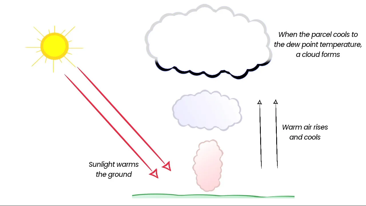
The new cloud will grow thicker as the 'leading' air parcel continues to rise, and more water vapour condenses out of it. Meanwhile, the conveyor of air parcels continues to feed the cloud more moisture, maintaining the cloud from below.
This process stops when a) the rising parcels finally cool to match the surrounding temperature, b) they run out of water vapour, or c) they encounter some opposing force, such as sinking air from above.
If there is enough water vapour in the air parcels, eventually precipitation forms. In a region of the world like Canada, this begins when the air parcels rise high enough that the temperature is below 0°C. The water vapour then freezes onto condensation nuclei, resulting in ice crystals, which collect more water vapour, grow into snowflakes, and fall towards the ground. The temperatures the snowflakes encounter on their way down determine what reaches the ground, whether it be rain, snow, or something in between.
...and grows into a storm
Now, the temperature difference between the air near the ground and the air high up determines exactly how fast the process of cloud formation happens.
In the case when that difference is very large — for example, it's +30°C at the ground and -30°C at the top of the troposphere — the buoyancy of the warm air parcels will send them soaring up into the sky. These are the 'unstable' conditions ripe for thunderstorm formation.
With the processes that formed the cloud continuing, unabated, the heat and moisture of the rising air builds the cloud upwards to a height of up to 10 kilometres. This is the 'developing' or 'towering cumulus' stage, where the vertical extent of the cloud is often quite a bit larger than its width, and the top resembles a head of cauliflower.
Inside the cloud, the conveyor of rising air parcels is strong enough that meteorologists give it a name — the 'updraft'.
The updraft continues to deliver heat and moisture up into the core of the cloud, growing it taller and taller. As ice crystals and snowflakes form, high up, and fall through the cloud, they melt, drawing heat from that part of the cloud, which sets up a 'downdraft' of sinking air just ahead of the updraft.

As the precipitation increases and the downdraft becomes stronger, the storm reaches its 'mature' stage. At this point, the storm cloud typically becomes tilted, with the updraft reaching even higher, so that it touches the top of the troposphere. At this point, the cloud to begin to spread out, resulting in the classic 'anvil' shape of a cumulonimbus.
Eventually, the downdraft will expand and diminish the updraft, causing the storm to lose its strength. This is the 'dissipating' stage.
While the storm is still in its mature stage, though, ice crystals, snow pellets, and raindrops churning about inside the cloud will knock and rub together, which causes some of the water molecules to exchange electrons. This results in a static charge separation between different parts of the cloud.
The exact charge exchange depends on temperature. Higher up in the cloud, where it's colder, the electrons move from the ice crystals to the snow pellets. So, as the lighter ice crystals get lofted to the cloud top, they take positive charge with them, while the heavier negatively charged snow pellets continue to fall. Lower down, where it's warmer, the electron exchange switches direction, resulting in positively charged snow pellets falling and melting into raindrops, and negatively charged ice crystals adding to the overall negative charge of the cloud core.
The final result is strong negative charge in the core, with strong positive charge at the cloud top and weak positive charge at the cloud base.

From this charge separation, a powerful electric field sets up within the cloud. This acts as the source for the multiple flashes of lightning we can see throughout the lifetime of the storm.
The storm doesn't produce all of that lightning all on its own, though.
Based on research conducted over the past few years, scientists have confirmed that each bolt of lightning we see is apparently triggered by cosmic ray particles from space hitting the top of the atmosphere.

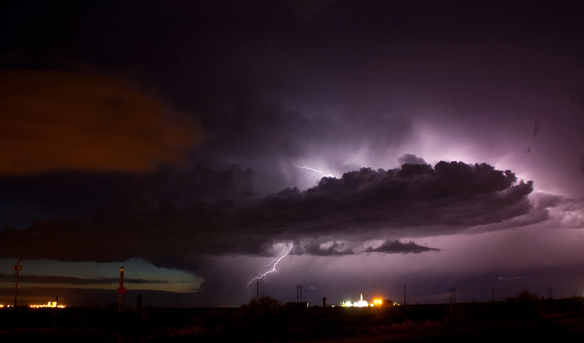
The processes of lightning formation, as described in the feedback loop, are shown here drawn onto a thunderstorm picture taken in New Mexico in 2014 by Stormhunter Mark Robinson.
Thunderstorms can last for hours at a time, depending on how much heat and moisture is available to sustain them.
They can form as lone storm clouds, or clusters of cells spread out across an entire air mass.
They can also become organized into squall lines, with several storms sweeping across the countryside in loose formation, typically lined up either along, or out ahead of, a cold front.

This radar image shows a squall line that formed across southern Ontario on March 29, 2025.
Some squall lines are so powerful that they are given a special name — mesoscale convective complexes (MCCs).
Mesoscale convective complexes differ from normal squall lines by their size, at over 100,000 square kilometres, and their extremely cold cloud tops, indicating just how unstable the atmosphere is where they are developing.
These particular lines of thunderstorms develop one day, typically in the afternoon, generate severe weather to start, which can persist late into the night, possibly even including tornadoes. After dying down by morning, leftover circulations from the squall can cause another line of thunderstorms to reform the next afternoon.
(Thumbnail image courtesy Mark Robinson, who captured this picture of a supercell thunderstorm as it passed near a truck stop in New Mexico, in 2014.)