When and where could a tsunami happen in the Atlantic Ocean?

The Atlantic coastline is vulnerable to tsunamis triggered by earthquakes and landslides across the ocean basin
Tsunamis are a hazard across all three of Canada’s coastlines. The threat for these dangerous and destructive waves is greatest along the West Coast—but the Atlantic seaboard isn’t immune.
Atlantic Ocean tsunamis are a rare but ever-present hazard throughout the basin. In fact, a particularly deadly tsunami struck Newfoundland in 1929.
Here’s a look at how and where these waves could occur in the Atlantic basin.
DON'T MISS: Earthquakes are a risk in Canada. Here's how to stay safe
Most tsunamis caused by subduction zone earthquakes
A tsunami is a series of large, persistent waves caused by the sudden displacement of a body of water. Earthquakes account for more than 80 per cent of tsunamis around the world, with the remainder caused by events like landslides and volcanic eruptions.

The largest earthquake-triggered tsunamis occur during temblors in subduction zones, where one tectonic plate slides beneath another.
This type of quake can force the seafloor to jut upward and displace a very large amount of water, potentially sending tsunami waves rippling thousands of kilometres across the ocean.
Most of the world’s major underwater subduction-type earthquakes typically happen in the Pacific and Indian Oceans, including the highly destructive 2011 Japan tsunami and the 2004 Boxing Day tsunami.
Historic tsunamis in the Atlantic
Where would a tsunami most likely occur in the Atlantic? We can look to the past for clues about what may happen in the future.
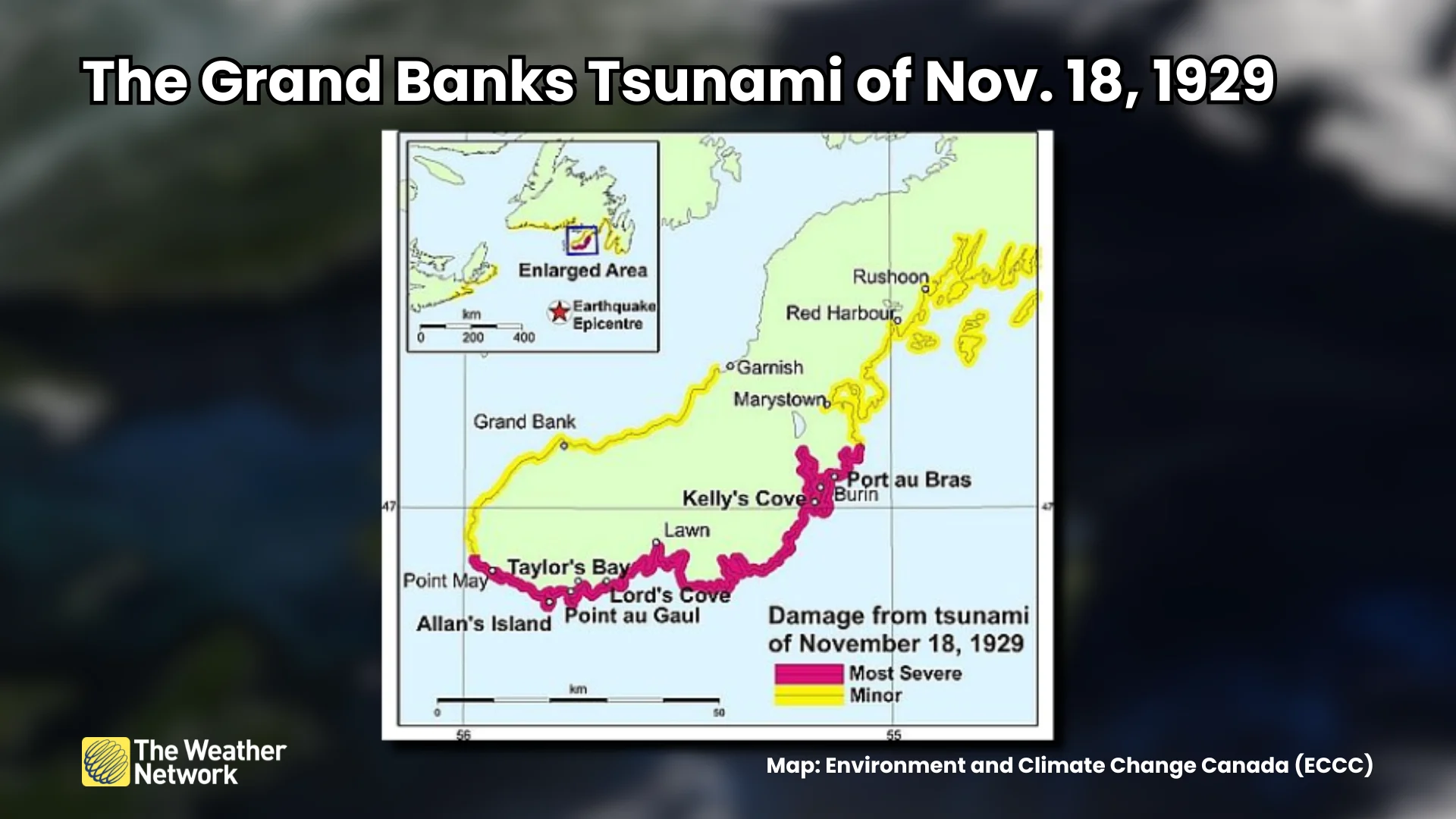
A magnitude 7.2 earthquake rattled the seafloor south of Newfoundland on November 18, 1929. The quake triggered an enormous underwater landslide and sent a destructive tsunami into the Burin Peninsula, where more than two-dozen people died.
RELATED: What is a tsunami? How these powerful waves spell coastal danger
Even farther back in time, a powerful earthquake struck just off the coast of Lisbon, Portugal, on November 1, 1755. The earthquake alone caused extensive damage in the region, let alone the immense tsunami it generated.
A significant inundation occurred across sections of the Iberian Peninsula, the Azores Islands, and northwestern Africa. Tsunami waves greater than 1 metre hit the coastline as far away as the Caribbean, Bermuda, and Newfoundland’s Avalon Peninsula.
WATCH: A computer model simulation of the Lisbon tsunami of 1755
Landslides pose the greatest hazard
Researchers looking into the risk for Atlantic tsunamis found in 2014 that large underwater landslides represent the greatest risk for generating these dangerous waves. Small landslides can cause localized tsunamis, while the largest events could pose a basin-wide hazard.
Locations that could produce underwater landslides capable of generating tsunamis include the continental slope off the eastern U.S. and Canada, as well as the Puerto Rican trench north of the Greater Antilles, and the Storegga slides off the coast of Norway.

MUST SEE: Tsunami safety tips: What to do if these dangerous waves threaten
Scientists have also identified volcanic activity in the Canary Islands as a potential source for future Atlantic tsunamis. The United States Geological Survey (USGS) reported in 2021 that a “worst-case scenario” collapse on La Palma could generate a tsunami of 1-3 metres along the U.S. East Coast.
While conditions in the Atlantic aren’t favourable for “megathrust” earthquakes like those seen off the coasts of Japan and Indonesia, powerful earthquakes around the basin can still generate dangerous tsunamis. The 2014 report points out that a Lisbon-type earthquake today could send waves up to 3 metres high into Atlantic Canada.
The USGS also identified numerous deadly tsunamis in the Caribbean as a result of strong earthquakes in the region, including a magnitude 7.5 earthquake in 1867 that reportedly produced waves as high as 12 metres in the U.S. Virgin Islands.
Header image created using graphics and imagery from Canva.