
200 million impacted by major ice, snow in generational storm

A significant winter storm is underway across much of the U.S., with destructive ice and disruptive snows forecast from Texas to Maine
A generational winter storm is underway across the United States this weekend, threatening a very large swath of the country with disruptive snows and a destructive ice storm.
This is the same system that will bring heavy snow to Ontario, Quebec, and Atlantic Canada over the next couple of days.

Millions of homes and businesses may lose power during and after this storm. Travel will be nearly impossible on many highways, and the national air system is heavily disrupted after more than 10,000 flight cancellations through Monday.
DON'T MISS: Freezing rain and ice pellets are dangerous winter hazards
The size and scope of this winter storm is exceptionally rare. More than 200 million people across the United States are under winter storm alerts, a huge expanse of land covering more than 3.3 million square kilometres.
Destructive ice storm unfolding
Powerful Arctic air sliding south across the U.S. will meet up with ample moisture streaming north out of the Gulf of Mexico, setting the stage for widespread wintry precipitation across the eastern two-thirds of the U.S.

Those warm southerly winds are a recipe for significant ice from freezing rain from Texas through Virginia. Widespread ice accretions of 10+ mm will lead to tree damage and power outages throughout the region.
Severe impacts from freezing rain are expected across portions of Louisiana and Mississippi, where ice accretions may approach 35 mm. A destructive ice storm is also expected across the Carolinas and northern Georgia, with widespread totals of 15-20 mm forecast.
Long-lasting and severe power outages are likely for many of the areas expecting freezing rain during this storm. Similar storms in the past, including in 1994 and 2002, knocked out power for 10 or more days in the hardest-hit communities.
WATCH: Large swath of U.S. prepares for destructive ice storm
Disruptive snows from Oklahoma City to Boston
Farther north, cold air locked in place will make this a memorable snowstorm from Oklahoma to New England.
A widespread swath of 20-30+ cm of snow will fall across the region, with the East Coast particularly hard-hit by the growing winter storm.

Based on current forecasts, many cities will see their highest snowfall totals in a decade or more.
Heavy, blowing snow will make travel difficult or impossible on many major highways throughout the affected regions. Flight cancellations due to snow and ice topped 10,000 through Monday, according to flight tracking company FlightAware.
Dangerous cold temperatures follow the storm
The risks won’t end when the storm is over. Dangerously cold air will remain locked in place across the eastern U.S. following the storm, with snow and ice on the ground helping to make temperatures even colder.

Widespread low temperatures in the -10s and even -20s are likely in this storm’s wake on Monday and Tuesday. This is life-threatening cold, especially given that long-lasting power outages could tally in the millions.
Tornadoes possible along the Gulf Coast
All that warm air surging north from the Gulf will fuel enough instability to spawn thunderstorms across the northern Gulf Coast. Some of those storms could turn severe.
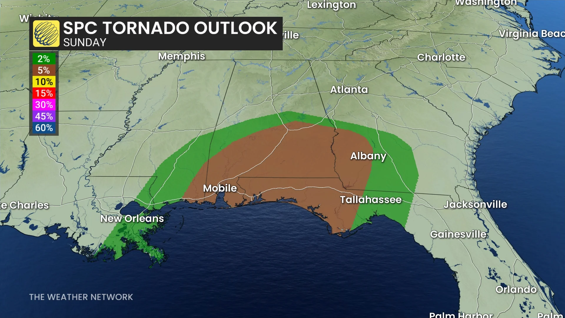
Cities like New Orleans, Biloxi, Mobile, Pensacola, and Panama City Beach are at risk for severe thunderstorms on Sunday.
The strongest storms could produce damaging wind gusts in excess of 100 km/h, as well as one or two tornadoes.