Abundant storm energy brings flood and tornado risks Thursday
Multiple rounds of severe storms are likely across eastern Ontario, southern Quebec, and northern New Brunswick Thursday. These storms could carry all hazards, including the potential for tornadoes in some regions. Stay alert to any warnings issued throughout the day.
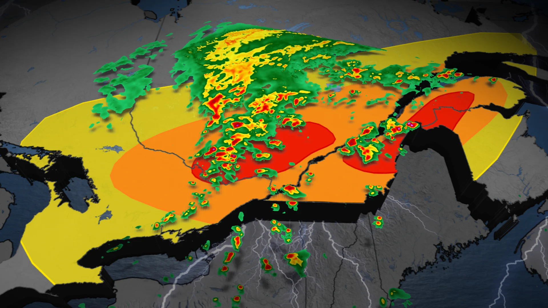
Thursday brings significant weather risks to eastern Ontario, southern Quebec and northern New Brunswick, as the recent high heat and humidity are providing ample storm energy across the regions.
MUST SEE: La Niña could return in a quick burst this fall and winter
Severe storms are expected in multiple rounds Thursday afternoon and evening, and after several days of heat and humidity above 30°C, the abundant moisture in the region could result in torrential downpours. Conditions may also align for potential tornado development north of the Ottawa Valley, across the Laurentians, and in the Gaspé Peninsula. A tornado warning covered the Pembroke, Ont. area just before the lunch hour, but was discontinued shortly after. Tornado-warned storms are likely throughout the day.

You'll want to stay updated on the weather alerts in your area as conditions can change quickly when severe weather hits.
Thursday: Risk of strong thunderstorms with heavy downpours and a possible tornado
A low pressure system and a strong cold front will move through the Great Lakes Thursday, tracking eastward through the day. These conditions will bring the potential for severe thunderstorms in several areas, particularly in eastern Ontario, southern Quebec, and parts of the Maritimes.
Storms moving through the Greater Toronto Area (GTA) are expected to remain non-severe, as energy will peak further east ahead of the cold front by the afternoon.

This increased energy, combined with ample moisture and notable wind shear, could fuel a strong cluster of storms.
SEE ALSO: What’s the wettest month in your corner of Canada?
North of the Ottawa Valley, severe storms could begin in the afternoon. By evening, areas including eastern Quebec, the Gaspé Peninsula, and northern New Brunswick will also face a severe weather risk.

Ottawa and Montreal residents should prepare for heightened storm intensity between 1–4 p.m., with the window extending from 1–7 p.m. for Quebec City and 3–9 p.m. for the Gaspé Peninsula and northern New Brunswick.
Locally intense rainfall is possible, with 50–100 mm expected in some areas due to thunderstorms.

This raises the risk of localized flooding. Conditions north of the Ottawa Valley, the Laurentians, and the Gaspé Peninsula may also support isolated tornadoes.
DON’T MISS: Tornado warning safety: Here’s what you should do
It will be important to stay weather-aware throughout the day, and keep updated on any weather alerts or warnings issued in your area.
Following Thursday's storm threat, relief from the heat is on the way, as cooler, drier air moves in for Friday. A more comfortable and seasonal weekend is ahead.
WATCH: How storm chasers in Canada got into the action-packed job
Stay with The Weather Network for all the latest on conditions across Ontario and Quebec.