
Back-to-back clippers bring 90+ km/h winds and snow to the Prairies
Expect challenging travel and potential power outages as strong winds and snow impact Alberta and Saskatchewan
High wind warnings are in place for parts of the southern Prairies.
Southern Alberta and southern Saskatchewan may see wind gusts exceeding 90 km/h through Tuesday morning. Drivers should also prepare for snow on Tuesday and Wednesday, which could cause whiteout conditions, especially in southern Saskatchewan and Manitoba, from Wednesday evening to early Thursday.
DON’T MISS: La Niña to continue into 2026, leaving thumbprint on winter weather
On Wednesday and Thursday, a powerful and disruptive storm will track across the Prairies with heavy snowfall and strong winds. Folks should brace for widespread road closures due to blizzard conditions and a flash freeze for parts of the region.
Steep temperature gradient drives strong winds
An extreme temperature gradient parked across the western Prairies will help fuel the development of the low-pressure system responsible for whipping up the strong wind gusts. The system will also bring snow and freezing rain.

Northern Alberta will see the heaviest snow, while southern areas remain milder due to downsloping winds along the southern foothills on Monday.
Wind gusts of 80–100 km/h are expected, with some communities in extreme southwestern Alberta, including Lethbridge, possibly seeing gusts exceeding 100 km/h.
RELATED: Why living in Calgary can be tough on migraine sufferers
Downsloping winds will help daytime highs in southern Alberta crest well above the freezing mark. Readings in the double digits are in the forecast for many areas.
Strong winds will spread into central and southern Saskatchewan by Monday night, possibly peaking at over 90 km/h by the pre-dawn hours on Tuesday.
Regina, Moose Jaw, and Swift Current are all forecast to gust higher than 80 km/h before the winds finally ease later Tuesday morning.
Wednesday will be the key day to watch
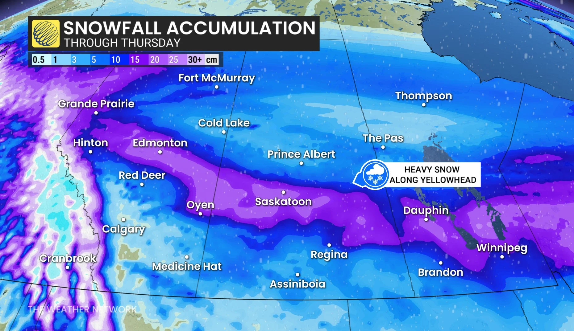
Wednesday brings a more intense, possibly disruptive Alberta clipper, with 15–25 cm of snow possible along key routes like the Yellowhead Highway.
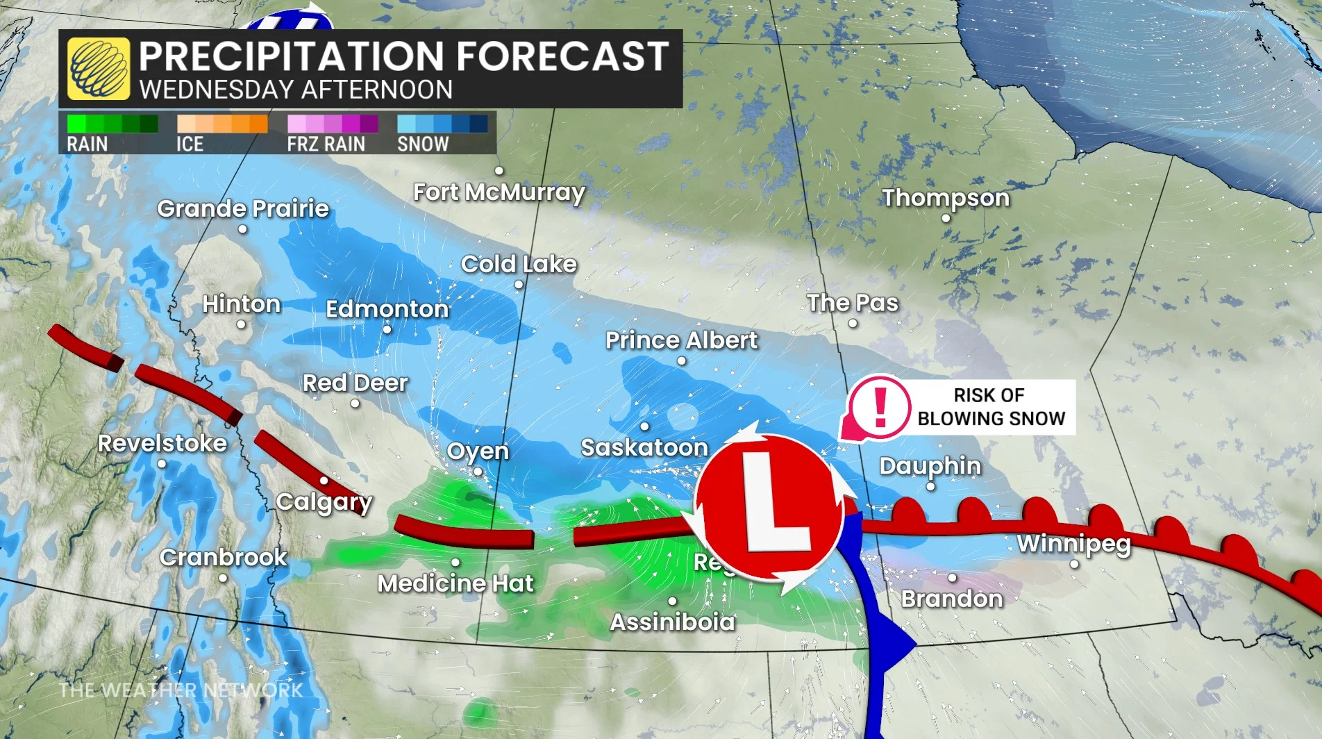
Snow will begin in central Alberta including Edmonton early Wednesday morning, then easing by the evening. Snow will spread into southern Saskatchewan late morning, becoming heavy by the afternoon.
By Wednesday afternoon, the snow moves into southern Manitoba, intensifying through the evening. Snowfall will wrap up Thursday morning.
Winds will strengthen, with gusts of 110+ km/h expected across southern Alberta, Saskatchewan, and Manitoba by Wednesday afternoon and overnight.
These strong winds, combined with snow, could create whiteout conditions in southern Saskatchewan and Manitoba from Wednesday evening through the pre-dawn hours on Thursday.
A flash freeze is also likely for southern areas, with temperatures plunging by 15 to more than 20 degrees in just six hours.
Widespread road closures are possible, as are power outages, so plan ahead and consider postponing non-essential travel.
WATCH: Why you shouldn’t park in a heated garage this winter
Stay with The Weather Network for the latest on conditions across the Prairies.