Conducive environment on the Prairies revives severe storm, supercell threat
A risk for severe thunderstorms will reappear on the Prairies Wednesday, including a supercell and a low, but non-zero tornado chance, as conditions will be favourable for active weather in all three provinces
The Prairies will be a hot spot of severe weather opportunity this week.
Wednesday and Thursday will see a risk of severe thunderstorms in parts of the region, with both days featuring the chances of large hail, heavy downpours and strong winds.
DON'T MISS: Get the latest wildfire news and safety tips to help you stay safe
On Wednesday, the environment will be particularly ripe for supercell development in parts of all three Prairie provinces. So, the chances for a funnel cloud or a tornado are low, but not zero.
It'll be important to remain weather-aware, and stay up-to-date on all of the latest watches and warnings as conditions change.
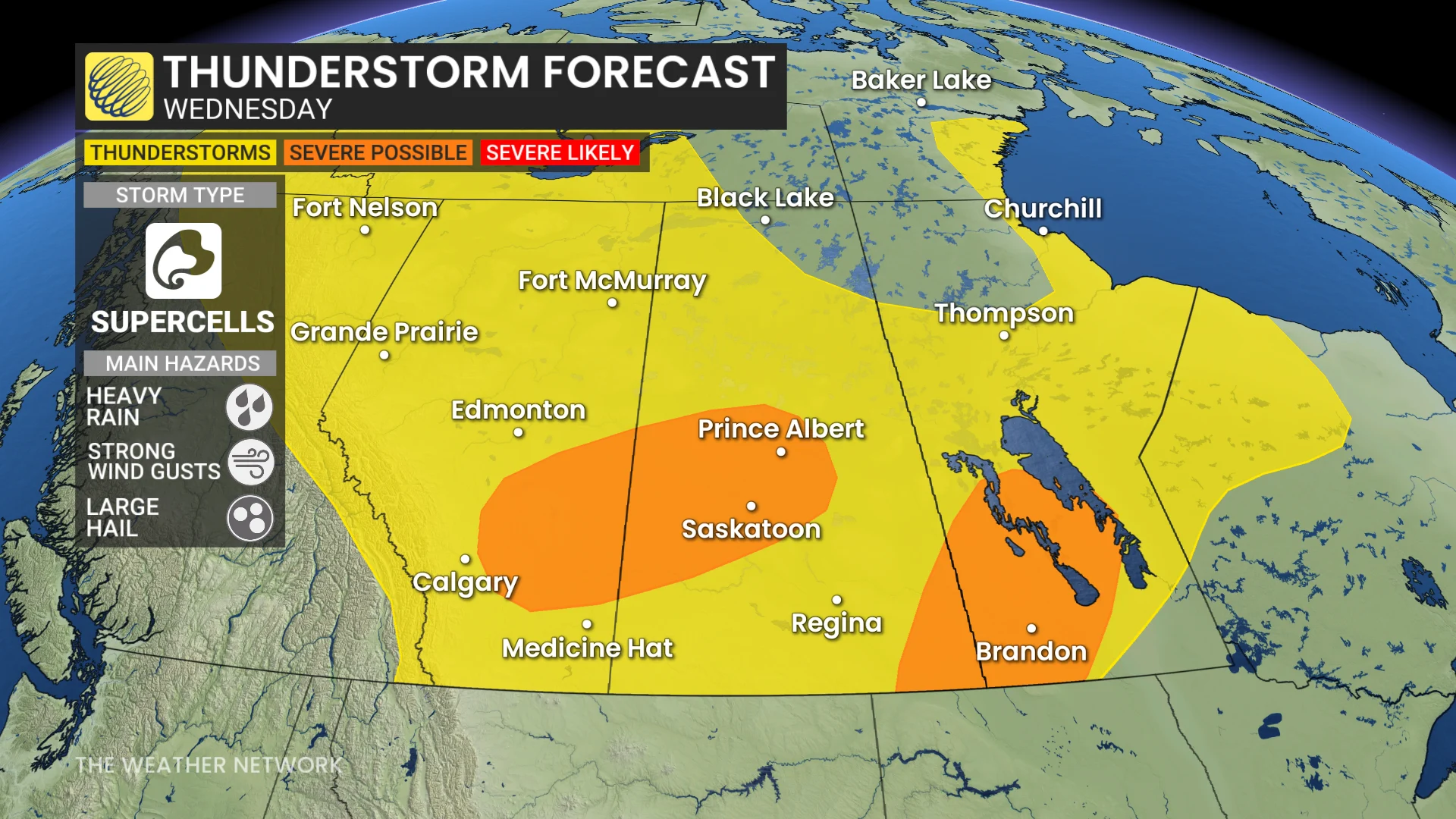
Wednesday: Severe storm, supercell risk in multiple provinces
A favourable environment for severe thunderstorm is forecast on the Prairies Wednesday afternoon and evening. A few supercells will be possible east of Calgary, Alta., and could track into Saskatoon, Sask.

Elevated thunderstorms may bring large hail, anywhere from two to four centimetres in size. Supercells are also possible in southeastern Saskatchewan and southwestern Manitoba.
A low-pressure centre may trigger severe thunderstorms in a higher wind shear and CAPE environment. As a result, the ingredients raise the risks for rotating supercells.
The chances for a funnel cloud or a tornado are low, but not zero.
DON'T MISS: 2025 is Canada's second-worst wildfire season on record for area burned
That part of the forecast has some uncertainty because there is a CAP (warm air inversion) in the atmosphere that storms would have to break through to develop and mature. Additionally, storms trigger here later by Wednesday evening, acting against tornadogenesis.

Hail of two to four centimetres in size and heavy downpours are the main risk.s
Thursday: Threat for severe storms moves east
Thursday’s several areas of instability come together in the form an organized, large, low-pressure system situated over northern Saskatchewan and Manitoba.

Widespread rain is expected near and north of the Yellowhead Highway, while severe weather potential exists in southern Manitoba and northwestern Ontario along the system’s cold front.
Storms in the south may be severe and impact regions near Winnipeg, Man., and Kenora, Ont.
SEE ALSO: Canada’s rain gauge runs dry, cities top weeks without rain
Cooler temperatures is anticipated for the western Prairies on the backside of the low. Regina, Sask., temperatures fall from 32 C Wednesday to 23 C on Thursday.
The eastern Prairies will see one or two days with highs only in the mid- to upper teens on Friday and Saturday.
A much drier pattern will then dominate across the region for the remainder of the month of August.
Be sure to check back for the latest updates across the Prairies.