
Severe storms prompt tornado warning in Saskatchewan, watches in Alberta
A severe thunderstorm capable of producing a tornado has been detected in southern Saskatchewan. Residents in the affected region should be in their shelters.
A tornado warning has been issued in southern Saskatchewan as meteorologists with Environment and Climate Change Canada (ECCC) are tracking a thunderstorm that is potentially producing a tornado.
In addition to potentially producing a tornado and intense winds, large hail and locally intense rainfall are possible. See below for the details.
Current tornado warnings
R.M. of Meota including Meota and The Battlefords Prov. Park
3:07 PM CST: Environment Canada meteorologists are tracking a severe thunderstorm that is possibly producing a tornado. Damaging winds, large hail and locally intense rainfall are also possible.
Tornado Location: About 25 km (24 km) east of Paynton
Motion: East at 40 km/h

Locations in the Path:Cochin, Meota, Battlefords Provincial Park, Aquadeo, Day's Beach, Martinson's Beach, Metinota, Prince, Sleepy Hollow and Vawn
This is a dangerous and potentially life-threatening situation.
Take cover immediately, if threatening weather approaches. If you hear a roaring sound or see a funnel cloud, swirling debris near the ground, flying debris, or any threatening weather approaching, take shelter immediately.
Go indoors to a room on the lowest floor, away from outside walls and windows, such as a basement, bathroom, stairwell or interior closet. Leave mobile homes, vehicles, tents, trailers and other temporary or free-standing shelter, and move to a strong building if you can. As a last resort, lie in a low spot and protect your head from flying debris.
Current tornado watches
CO. OF NEWELL NEAR BROOKS ROSEMARY AND DUCHESS
S.A. 2 NEAR CESSFORD WARDLOW AND POLLOCKVILLE
S.A. 4 NEAR HEMARUKA WISTE AND MONITOR CREEK
S.A. 4 NEAR KIRRIEMUIR AND COMPEER
S.A. 3 NEAR YOUNGSTOWN
S.A. 3 NEAR BIG STONE CAPPON AND GOLD SPUR
S.A. 3 NEAR SEDALIA AND NEW BRIGDEN
S.A. 3 NEAR OYEN AND CEREAL
S.A. 3 NEAR SIBBALD AND ESTHER
M.D. OF PROVOST NEAR BODO
M.D. OF ACADIA INCLUDING ACADIA VALLEY
CYPRESS CO. NEAR TIDE LAKE
S.A. 2 NEAR IDDESLEIGH AND DINOSAUR PROV. PARK
S.A. 2 NEAR JENNER AND ATLEE
S.A. 2 NEAR BUFFALO AND CAVENDISH
S.A. 2 NEAR BINDLOSS EMPRESS AND SOCIAL PLAINS
CO. OF NEWELL NEAR PATRICIA
CYPRESS CO. NEAR CFB SUFFIELD
CYPRESS CO. NEAR BOWMANTON SCHULER AND HILDA
CYPRESS CO. NEAR MCNEILL AND SANDY POINT DISTRICT PARK.
2:49 PM MDT: Conditions are favourable for the development of severe thunderstorms which may produce tornadoes. Strong winds, large hail and heavy rain are also possible.
There is a slight risk that a severe thunderstorm could develop this afternoon and produce a tornado. The tornado risk will diminish early this evening.
This is a dangerous and potentially life-threatening situation.
Be prepared for severe weather. Take cover immediately, if threatening weather approaches.

In the event of a tornado, or if a tornado warning is issued for your area, it is recommended you take the following actions: Go indoors to a room on the lowest floor, away from outside walls and windows, such as a basement, bathroom, stairwell or interior closet. Leave mobile homes, vehicles, tents, trailers and other temporary or free-standing shelter, and move to a strong building if you can. As a last resort, lie in a low spot and protect your head from flying debris. Lightning kills and injures Canadians every year. Remember, when thunder roars, go indoors!
Tornado watches are issued when atmospheric conditions are favourable for the development of thunderstorms that could produce tornadoes.
Wednesday: Severe storm threat, but with desperately needed rainfall for the wildfire zones
An unstable atmosphere is expected to develop Wednesday as a large, upper-level low interacts with a warm ridge of high pressure.
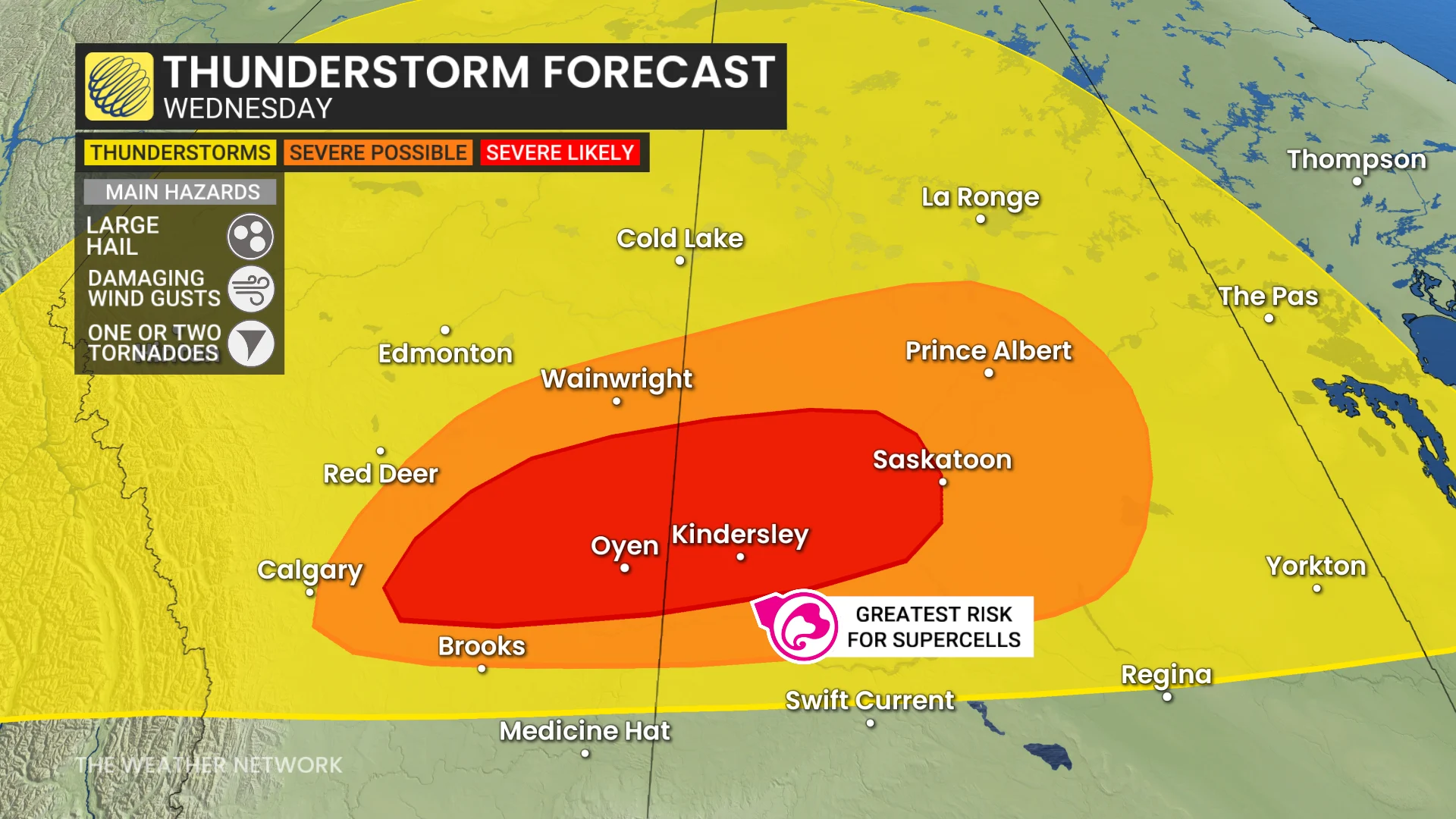
Isolated thunderstorms are forecast Wednesday afternoon across northern and central Alberta and Saskatchewan, with a focus on areas from east of Calgary, Alta., to Saskatoon, Sask., for potential severe storms by early evening.
Supercells may form in Alberta and track eastward into Saskatchewan, bringing risks of large hail (3-5 cm, or loonie- to golf ball-sized), and possibly one or two tornadoes. Damaging wind gusts of 90-110 km/h could also accompany maturing storms.
Overnight, this system is expected to bring persistent rain into wildfire-affected areas of Saskatchewan and Manitoba, offering much-needed relief through Friday, when as much as 30-80 mm could fall.
DON'T MISS: 2025 is Canada's second-worst wildfire season on record for area burned
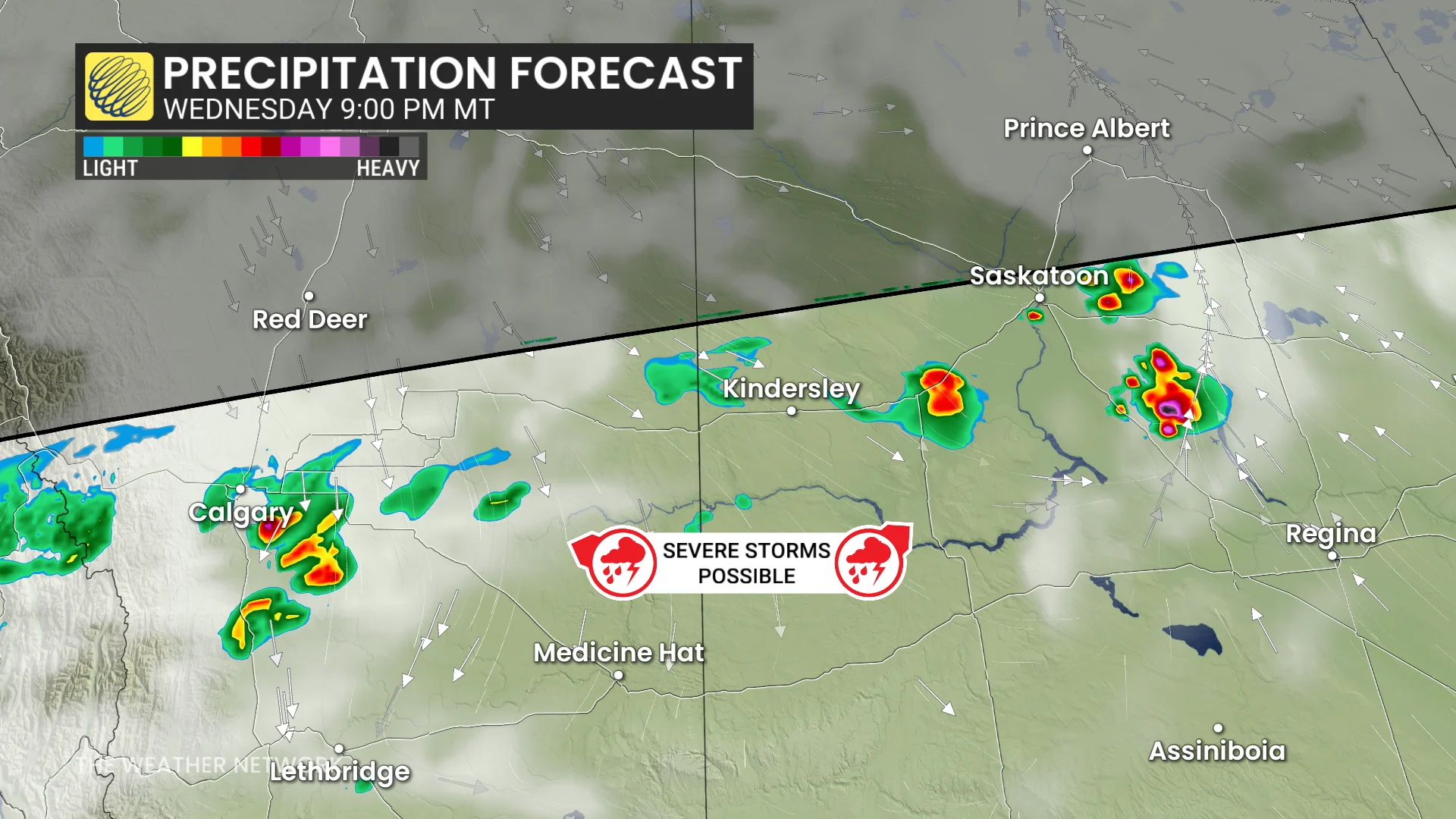
However, southern and central Saskatchewan could see isolated strong storms overnight, with the potential for additional large hail and heavy rain as the system tracks eastward.

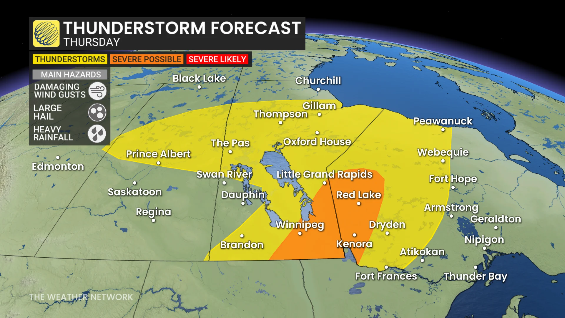
Thursday: Storm risk shifts east, Alberta significantly cools
By Thursday, the storm system will shift eastward, bringing a significant cooldown to Alberta, with daytime highs falling below 17°C.
SEE ALSO: Canada’s rain gauge runs dry, cities top weeks without rain
In southern Manitoba and northwestern Ontario, high thunderstorm energy will build through the afternoon. The system’s advancing cold front is expected to trigger potentially severe storms by late afternoon into the evening.
There is some uncertainty where thunderstorms will trigger, but a potent environment is present for large hail and damaging winds storms near the Winnipeg area and east.
Beyond, temperatures will be changeable through the weekend. Northern areas will be cooler than normal, but the southern Prairies will end up warmer than normal with a couple rounds of warmer weather surging north of the U.S. border. Warmer-than-normal temperatures will dominate next week.
Be sure to check back for the latest updates across the Prairies