Dangerous snow squalls continue Monday with an additional 10-15+ cm
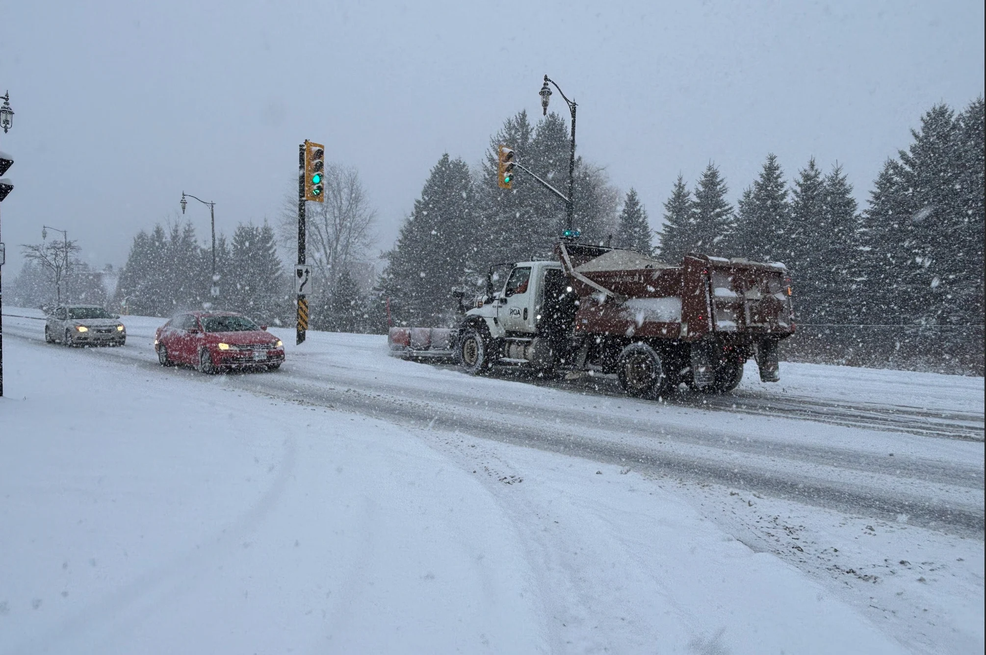
Drivers should prepare for more hazardous travel conditions downwind of Lake Huron and Georgian Bay through the day on Monday
Cold northwesterly winds sweeping across Ontario are creating conditions for significant snow squall development. Snow squall warnings remain in effect for certain snowbelt areas downwind of Lake Huron and Georgian Bay, as well as some lingering winter weather travel advisories.
"Travel may be hazardous due to sudden changes in the weather," warns Environment and Climate Change Canada (ECCC) in the advisory.
DON’T MISS: Beware the dangers of fall snowstorms across Canada
Significant travel impacts are expected to persist in affected areas, particularly near London and Barrie, located within the primary snow squall bands. Road closures may occur, so consider adjusting travel plans until conditions improve.

Drivers should remain aware of rapidly changing conditions over short distances. Visibility can change from clear to a whiteout when approaching a snow squall.
Snow squalls expected to stay through Monday morning
Cold, northwesterly winds blowing across the relatively warm lakes have provided the classic setup for lake-effect snow squalls to develop over communities downwind from Lake Huron and Georgian Bay.
Wind gusts will slightly weaken on Monday, but will continue to support snow squalls affecting areas from Goderich to Long Point along Lake Huron.

By Monday afternoon and evening, squalls are expected to ease as warmer air moves in and winds shift.
Snowfall totals through Tuesday will vary significantly depending on squall placement.
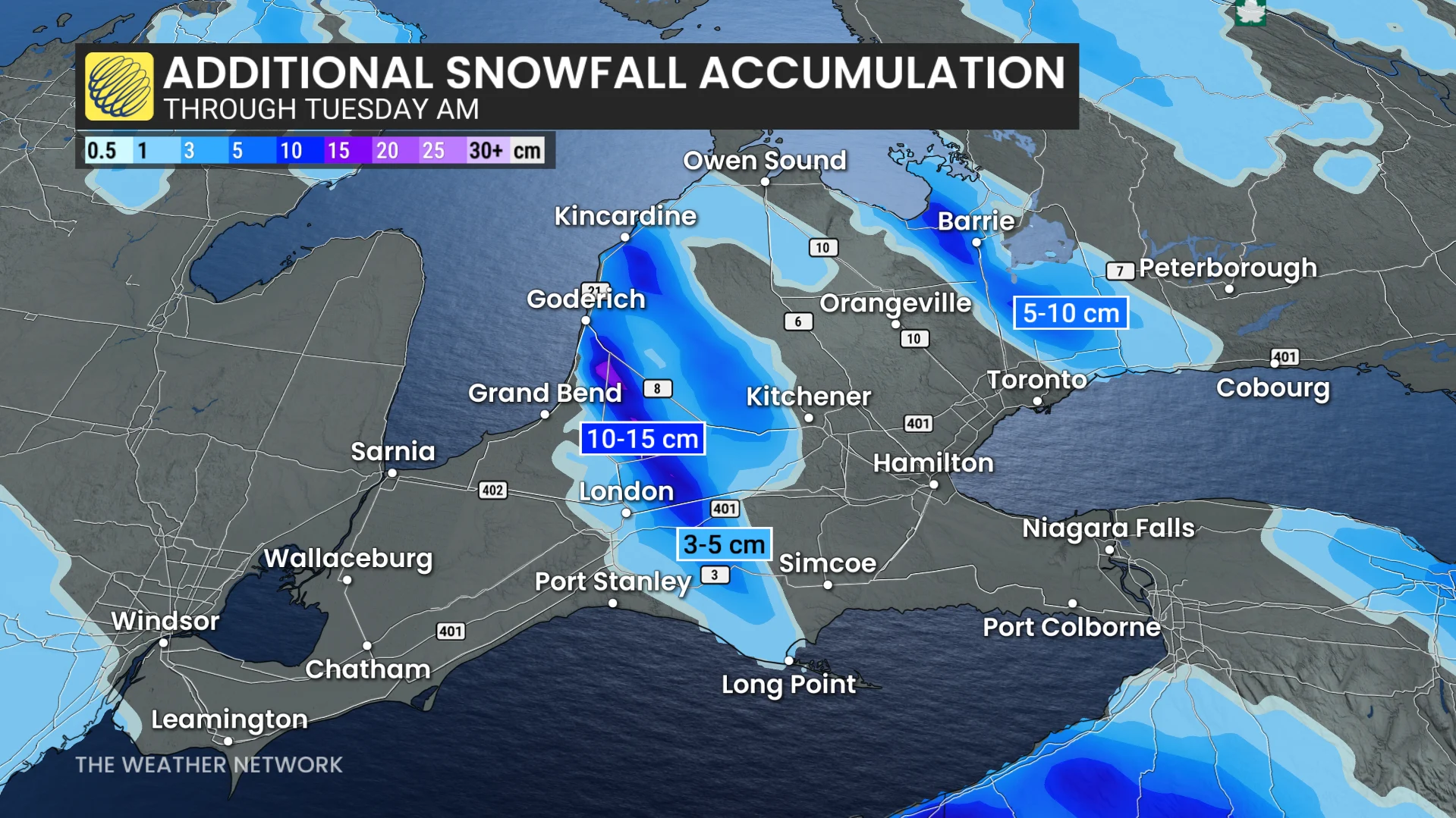
Georgian Bay Band: Hard-hit areas could see between 5-10 cm, with localized amounts exceeding 15 cm southeast of Georgian Bay.
Lake Huron Band: An additional 10-15 cm is likely for portions of Huron, Middlesex, Elgin, Perth, and Oxford counties.
Highway 3, Highway 4, Highway 21, and Highway 401 are some of the routes impacted.
WATCH: Potent snow squalls rolling across southwestern Ontario
Expect driving to be difficult at times, and the stiff gusts could further reduce visibility during periods of snowfall.
A span of chilly but calm weather is anticipated for midweek. By late in the week or the weekend, a more active weather pattern is expected to develop, potentially continuing into the following week. While the exact storm track is still uncertain, current indications point toward a milder and wetter scenario.
DON'T MISS: Abrupt transition to winter: Canada’s 2025-26 winter sneak peek
As December approaches, a shift to colder and more wintry weather is expected. Early forecasts suggest December’s first half will feature a predominantly wintry pattern with below-normal temperatures.
Stay with The Weather Network for all the latest on conditions across southern Ontario.