
Freezing rain threatens dicey travel, power cuts in eastern Ontario, Quebec
A messy system and temperatures near the freezing mak will bring a period of freezing rain to parts of eastern Ontario and Quebec this weekend, making road and surface conditions quite icy, slippery and difficult to navigate.
Rain, freezing rain, and snow are all on the table in parts of Ontario and Quebec this weekend, but what you get will depend on where you are.
Unlike the fall and winter storms we usually see, where the precipitation transitions as the system moves through, this will be more of a story of "what you see is what you get."
SEE ALSO: La Niña continues, but these factors may matter more this winter
In eastern Ontario and Quebec, freezing rain will the biggest concern, with freezing warnings in place. Icy surfaces could be difficult to detect. More than eight hours of freezing rain possible across the National Capital Region, beginning Saturday afternoon. There is risk of injury due to slips and falls as pavement, sidewalks and surfaces will become icy and slippery.
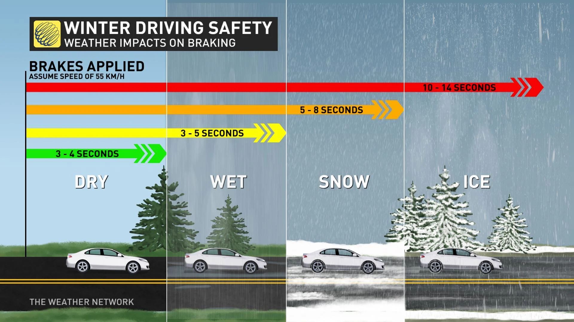
Anticipate some travel delays or impacts on Saturday night through Sunday as the bout of the wintry weather occurs, especially in areas seeing freezing rain and/or snow. Scattered power outages and dicey travel are possible where freezing rain occurs.
This weekend:
Active weather moving across the northern Prairies will impact Ontario and Quebec this weekend.

The main story, however, will be in eastern Ontario and Quebec, where we are looking at freezing rain developing across the Ottawa Valley and parts of southern Quebec. Marginal temperatures in those areas may bring a threat for several hours of freezing rain from Saturday afternoon into the early hours on Sunday morning.
This will bring trickier, more impactful forecast for the pockets of eastern Ontario and Quebec, where up to 10 mm of ice accretion is possible. Totals will likely varying by subtle differences in elevation and temperature.
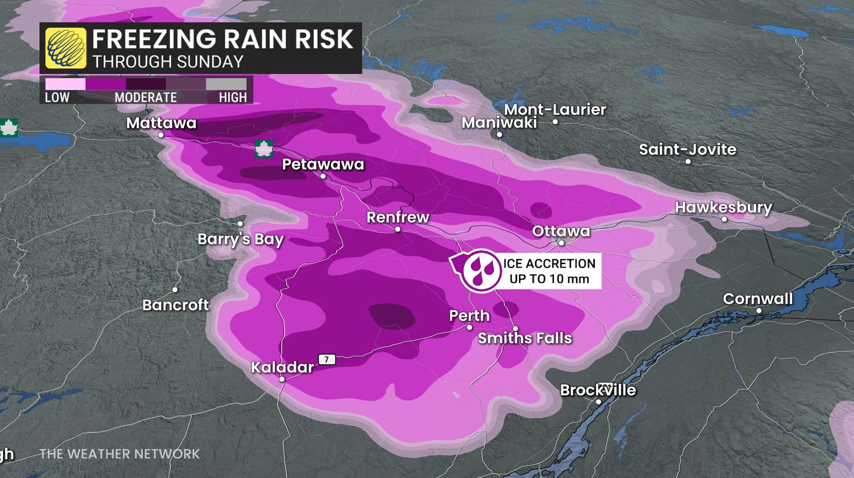
More than eight hours of freezing rain is possible across the National Capital Region, beginning Saturday afternoon.
Temperatures near 0°C all day will support ice accretion in Ottawa and surrounding communities. Icy conditions will stretch westward through Petawawa, Pembroke, Renfrew, and Arnprior, including sections of the Trans-Canada Highway.
DON'T MISS: Winter-proof your home with a heat pump that even works in -30°C
Montreal is unlikely to see sustained freezing rain, but rather periods of snow, with higher accumulations farther north of the city. With Montreal remaining at or below freezing, 5-10 cm of snowfall is expected to accumulate through Sunday morning.

Elsewhere in Quebec, Up to 15 cm of snowfall is possible farther north towards Trois-Rivières and along portions of Autoroute 40.
Looking ahead
A couple of significant systems are expected to approach the region later next week and weekend. The storm track is uncertain and that will be critical to whether we can get a stretch of mild weather versus changeable temperatures, with a risk for messy impacts. At this point, a milder and wetter scenario is favoured, especially for southern and western parts of the region.
However, a very wintry pattern is expected to dominate during December with colder-than-normal temperatures. An active pattern is expected to accompany that transition during the final week of November.
Stay tuned to The Weather Network for the latest forecast updates for Ontario and Quebec.