Widespread rains, thunder, and... snow? Ontario may see it all this week
An incoming low will bring widespread rain, gusty winds, and a temperature drop early in the week ahead of a second system that will see snow chances creep back into the province.
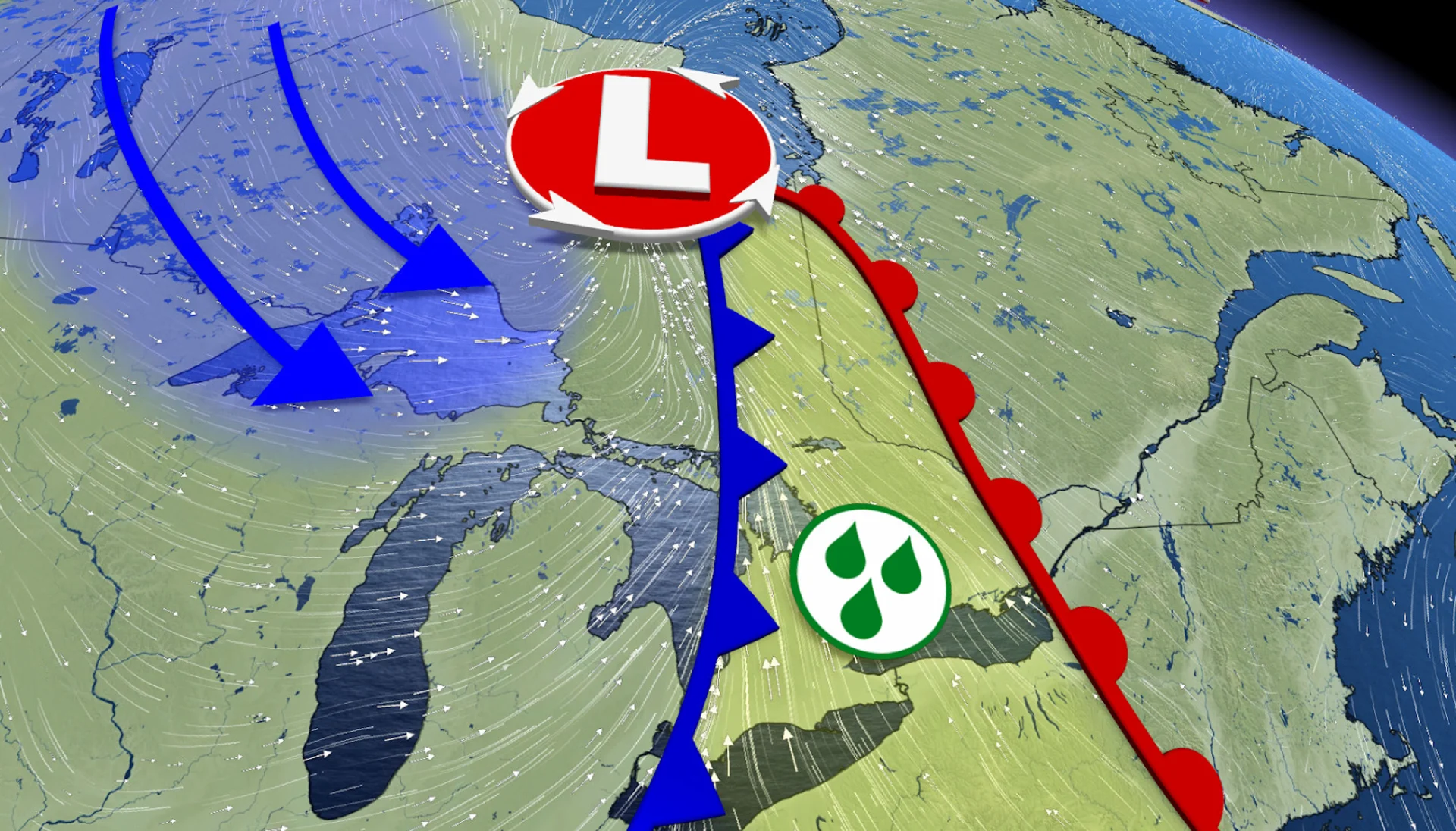
Between flooding in northern Ontario and wild temperature changes, it's been a rollercoaster of a spring across Ontario. The ride isn't done just yet, either, as we watch a rainy system move across northern Ontario early in the week, followed by another rainy system to the south. Folks across the province may also see a few dreaded snowflakes fall from the sky behind each system.
With the snowpack finally melting across northern Ontario, many communities are seeing an increased flood risk. Much of northeastern and eastern Ontario remains under widespread flood warnings, while the Thunder Bay and Wawa-Sault Ste. Marie areas around Lake Superior are under flood watches.
SEE ALSO: After Alberta's April snowstorm, can we say goodbye to snow in May?
While the northwest isn't under any flood watches, we did see some highway closures due to localized flooding in Atikokan and Kenora over the weekend, according to the Ontario Provincial Police.
Stay alert for any localized flooding or flood alerts as the widespread rains trek across the province this week.

Weather highlights:
20-30+ mm rain forecast across northwestern Ontario Monday, as well as a swath of 5-10 cm snow
Rain pushes east Tuesday, bringing 10-20+ mm to northeastern Ontario
Parts of southern Ontario could see some thunderstorms embedded in the rain early Tuesday morning
Winds pick up early Tuesday, with 50-70+ km/h wind gusts
Eastern Ontario could see 30-50+ mm rainfall Wednesday evening and overnight
Cooler temperatures move in mid- to late week
Monday: Widespread rains and snow in the north, spring warmth in the south
Rain began across northwestern Ontario early Monday and will continue to spread across the region through the afternoon and evening, with 20-30+ mm of rain forecast.
We could see periods of heavy rain north of Lake Superior through the overnight on Monday, which has prompted rainfall warnings to be issued for the Nipigon and Terrace Bay areas. Stay alert for localized flooding on roads and highways when travelling.
As cold air wraps in behind the system, there is also a risk for some snow to fall. A swath of 5-10 cm of late-April snowfall is possible along the system's northern edge--north of Dryden.
Meanwhile, sunshine and above-seasonal temperatures will dominate across southern Ontario. Temperatures in the southwest will likely reach the 20s, although breezy conditions will move in from the southeast.

Tuesday: Rain, thunder, and gusty winds spread southeast
By early Tuesday, the rain and snow will have spread into northeastern Ontario, with 10-20+ mm of rain forecast. Travellers should keep an eye out for any new flood alerts or highway/road closures, as much of the region is under a flood warning due to the spring snowmelt.
The rains will also make their way into southern Ontario early Tuesday morning, along with some scattered thunderstorms embedded in the rain. The rainfall in any embedded thunderstorms could become heavy to torrential at times.
DON'T MISS: Dramatic spring pattern split spawns fires and floods
The rain will taper off into scattered showers through the morning, and we'll see the rainfall risk become isolated to the Greater Toronto Area (GTA) by the afternoon as the system's front moves into eastern Ontario.
Winds are also forecast to pick up during the pre-dawn hours on Tuesday, with gusts between 50-70+ km/h, and stick around throughout the morning and early afternoon.

Temperatures are at least forecast to stay fairly mild, but that will come to an end on Wednesday as below-seasonal air moves in behind the system.
Up to 50+ mm rain threatens eastern Ontario while the snow risk creeps south by midweek
Another, more unorganized system, will sneak into the province on Wednesday and tap into even more atmospheric moisture. Much of eastern Ontario will likely see moderate to heavy rains Wednesday night and into Thursday, with 30-50+ mm forecast for the flood-stricken region.

The GTA is also forecast to see a good amount of rain, raising the risk for localized flooding across the sprawling cities.
Even cooler air will wrap in behind this second system, raising the chances of seeing some snow across cottage country, as well as eastern Ontario and maybe parts of southern Ontario.
Stay with The Weather Network for more information and updates on your forecast across Ontario.