
Historic Hurricane Humberto hits Category 5 intensity
All eyes are on Humberto and a brewing tropical storm threatening the southeastern U.S.
Hurricane Humberto swirled into the history books Saturday evening after the powerhouse storm reached scale-topping Category 5 intensity.
While the fierce storm won’t directly make any landfalls, it will generate potentially deadly rip currents into next week.
Humberto will, however, influence the track of Tropical Depression Nine, a growing storm that threatens significant issues across the southeastern United States.
DON’T MISS: What does a hurricane's ‘cone of uncertainty’ mean?
Hurricane Humberto now a Category 5
Forecasters found that Hurricane Humberto’s maximum winds reached 260 km/h on Saturday evening, topping the scale and placing the storm among a rare few in Atlantic storm history.

Humberto is now the 44th hurricane in the Atlantic to hit Category 5 intensity. This is the 12th storm to achieve that feat in the past ten years, and the sixth to do so since 2022.
The storm will remain a major hurricane into early next week as it rounds a large ridge of high pressure parked over the central Atlantic Ocean. Bermuda should carefully watch the track of the hurricane as it passes the island.

Dangerous rip currents are likely up and down the U.S. East Coast into early next week, potentially reaching Atlantic Canada later in the week. Rip currents are a deadly hazard to even the strongest swimmers.
Next storm may threaten southeastern U.S.
Farther west, Tropical Depression Nine continued to gradually organize as it pushed north through the Bahamas on Saturday.
This system, expected to become Tropical Storm Imelda by Sunday, will come close to the southeastern U.S. by Monday and Tuesday. Tropical storm watches are in effect for portions of the Florida coast ahead of the storm’s arrival.
RELATED: The high-stakes factors that decide where a hurricane tracks
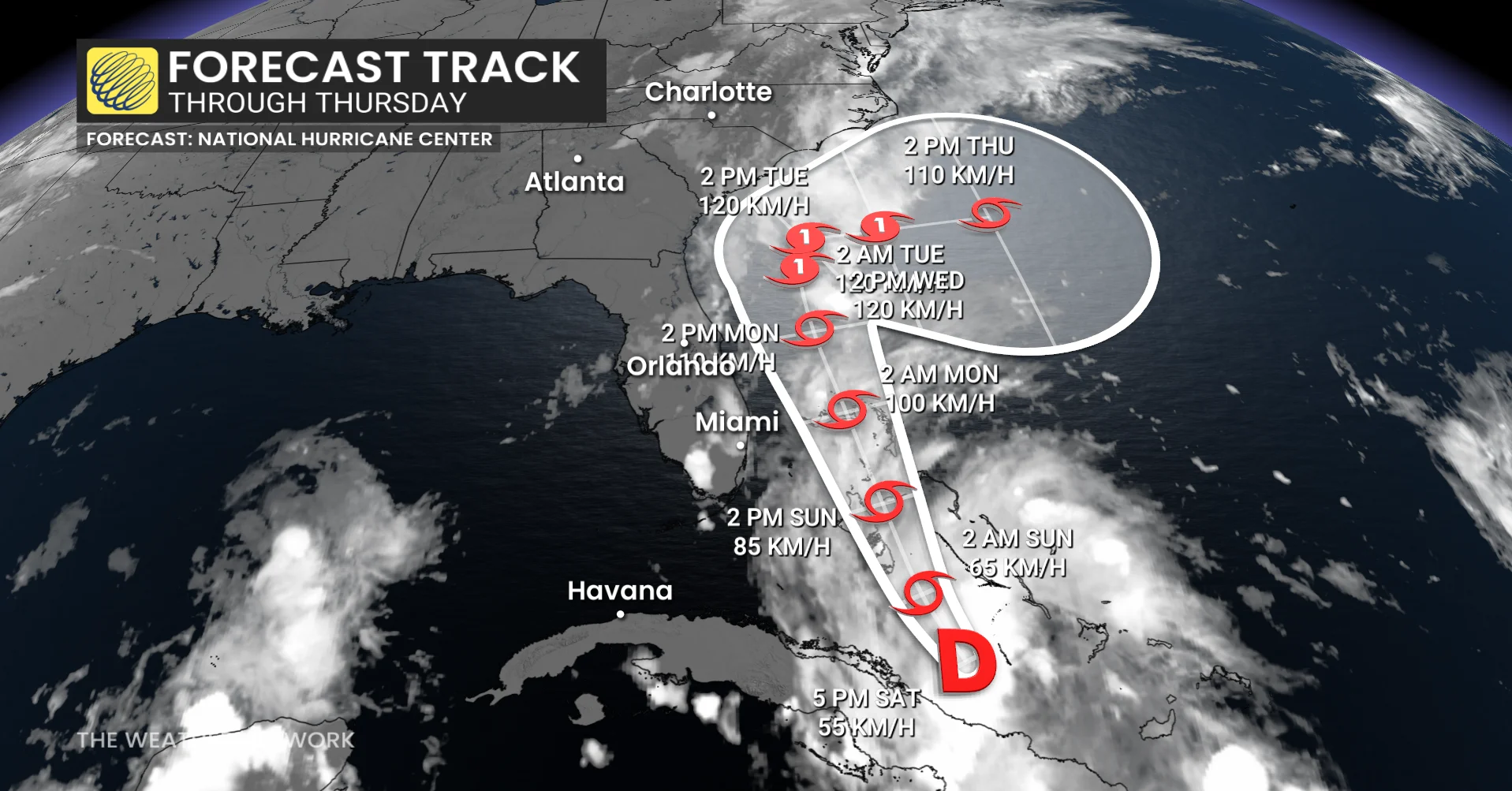
A complex atmospheric setup will cause steering currents to collapse around the system as it approaches the U.S. early next week, forcing the storm to slow to a crawl.
Given this setup, we’re seeing higher-than-normal uncertainty surrounding the storm’s future track.
The most likely scenario, reflected in the U.S. National Hurricane Center’s (NHC) forecast, is that Humberto will cause a break in the ridge which will offer the system an ‘escape route’ of sorts to make a hard right turn out to sea by midweek.
It’s still possible that the system will come much closer to land, which would greatly increase the flooding impacts of very heavy rainfall across Georgia, the Carolinas, and Virginia.
Anyone with interests in the region should closely monitor the forecast in the days ahead.
Stay with The Weather Network for all the latest updates on the tropics.