
How Humberto could create U.S. coast risk with the next hurricane
While Humberto is expected to remain a major hurricane through early next week, the soon-to-be named storm, Imelda, will pose a threat to the Bahamas and possibly the southeastern U.S., with the aforementioned's help, in the near future
As Hurricane Humberto continues to intensify, forecasters are now looking at a soon-to-be tropical storm with more concern as it has an uncertain track, with one scenario that puts it on track to make a southeastern U.S. landfall in the near future.
Currently known as Potential Tropical Cyclone Nine is forecast to become a named storm, Imelda, in the second half of the weekend and a hurricane by early next week. Forecast models are showing two scenarios, which both carry a considerable amount of uncertainty, thanks to the influence of Hurricane Humberto, and a ridge and a trough in the U.S.
DON’T MISS: What does a hurricane's ‘cone of uncertainty’ mean?
While the Bahamas will see considerable impacts from future Imelda with certainty, it is unclear, exactly, what impacts the southeastern U.S. may see, including a possible landfall.
Humberto to remain a major hurricane into next week
A favourable environment allowed Humberto to undergo rapid intensification on Friday as it passed far north of the Leeward Islands.
As of Saturday morning, the U.S. National Hurricane Center (NHC) found its maximum and sustained winds are near 230 km/h with higher gusts. Humberto is a Category 4 hurricane. Additional strengthening is forecast through the weekend, with a brief peak at 260 km/h (Category 5 status), but the environment early next week becomes more hostile to support such intensity.
The forecast track and ridge breakdown may influence the next hurricane in the Atlantic. The circulation from Humberto could help pull the system away from the U.S. coast.

By early Monday, a turn toward the northwest at a slightly faster forward speed is forecast followed by a turn toward the north-northwest by Monday night.
Humberto is this season’s third hurricane behind Erin and Gabrielle. This is the first time in 90 years we’ve seen a season’s first three hurricanes intensify to Category 3 status or stronger, according to hurricane expert Philip Klotzbach.
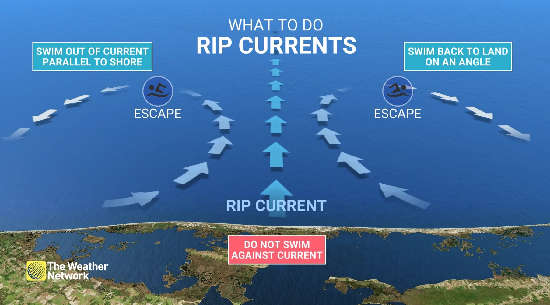
Swells generated by Humberto will begin affecting portions of the northern Leeward Islands, the Virgin Islands, Puerto Rico, and Bermuda this weekend and early next week. These swells are likely to cause life-threatening surf and rip current conditions.
Future Imelda brewing near the Bahamas
Another system, currently known as Potential Tropical Storm Nine, nearby may cause some serious issues across the southeastern U.S. early next week.

The NHC began issuing advisories on Potential Tropical Cyclone Nine on Friday evening. This special designation allows forecasters to issue watches and warnings on a tropical disturbance that’s expected to develop and hit land within the next 24 to 48 hours.
RELATED: The high-stakes factors that decide where a hurricane tracks

Meteorologists expect this system to organize into a tropical depression or storm by Saturday night. Once it is named, it will become Tropical Storm Imelda. It is then forecast to reach hurricane status by late Monday.
The forecast grows trickier from there.
Currently, the NHC has the centre of the system moving across the central and northwestern Bahamas this weekend, and approaching the southeast U.S. coast early next week. So, the official forecast has it remaining offshore, but close enough for significant wind, rain and surge impacts.

An eastward turn is supported by the majority of models, in part due to the influence of Hurricane Humberto.
But latest trends show a ridge to the east and a trough over the U.S., expected to greatly influence the track, bringing a turn to the north-northwest. The 72-hour outlook has some uncertainty, with some models showing a potential landfall across the southeastern U.S.
Those with interests elsewhere in the Bahamas and along the southeastern coast of the United States, from Florida to North Carolina, should monitor the progress of this system.
At the moment, tropical storm warnings are in effect for the central and northwestern Bahamas.
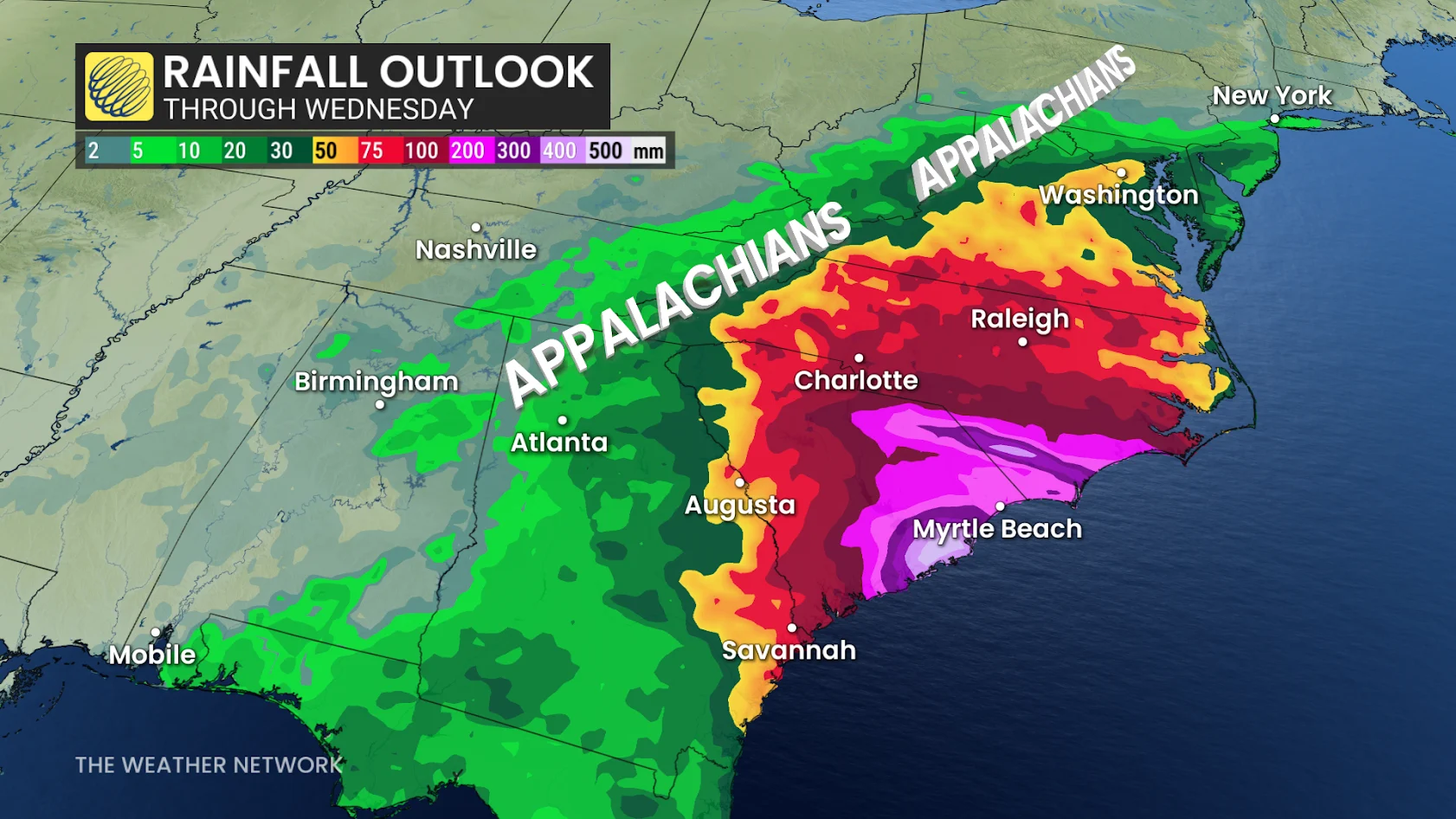
The disturbance is expected to produce 200 to 300 mm of rain, with isolated maximum totals of 400 mm possible to eastern Cuba, and 100 to 200 mm of rain to the Bahamas. This rainfall will likely produce flash and urban flooding. Mudslides are also possible in areas of higher terrain across eastern Cuba, Hispaniola, and Jamaica.
As well, moisture from the disturbance is leading to a threat of heavy rainfall from this system well to the north across portions of the U.S. Southeast and Virginia into early next week. That could cause flash, urban and river flooding.
As well, swells generated by both this system and Hurricane Humberto will affect portions of the Bahamas this weekend, and spread to portions of the southeast U.S. coast early next week. These swells are likely to cause life-threatening surf and rip current conditions.
A tropical system in this part of the world is unwelcome news as western North Carolina continues recovering from the devastating flooding inflicted by Hurricane Helene last September.
North Carolina Gov. Josh Stein’s office reported on Sept. 25 that 95 per cent of public roads damaged by Helene’s flooding have been repaired, and 57 per cent of public bridges damaged during the storm have been repaired or replaced. Crews had removed more than 6.1 million cubic metres of debris from waterways as of Sept. 16.
Stay with The Weather Network for all the latest tropical updates.
Thumbnail courtesy of NOAA.