Major hurricane threat grows as two systems brew in the Atlantic
Humberto is set to become a major hurricane over the next couple of days
The peak of hurricane season is upon us as forecasters watch three systems over the Atlantic Ocean.
What’s left of Hurricane Gabrielle is racing toward Europe as eyes turn toward two systems much closer to North America.
Tropical Storm Humberto is poised to become a strong hurricane in the southwestern Atlantic, while a nearby disturbance may pose a threat to land by early next week.
DON’T MISS: What does a hurricane's ‘cone of uncertainty’ mean?
Azores on alert as Hurricane Gabrielle races into the region
Gabrielle completed the final stage its eventful life on Thursday as it races toward Portugal’s Azores Islands. The system lost its tropical characteristics just before crossing the archipelago late Thursday evening local time.
Sustained winds of 100+ km/h, destructive waves, storm surge flooding, and flash flooding from heavy rainfall are possible as the system charges across the region overnight into Friday. Gabrielle’s remnants will likely bring foul weather to the Iberian Peninsula this weekend.
Humberto set to become a major hurricane
Humberto is a healthy tropical storm in the southwestern Atlantic.

The system is in a favourable environment for intensification as it moves northwest around a ridge of high pressure parked over the ocean basin.
Forecasters with the U.S. National Hurricane Center (NHC) expect Humberto to grow into a hurricane—potentially a major hurricane—by this weekend.
MUST SEE: Study urges forecasters to adopt new hurricane intensity scale
If the forecast comes to pass, Humberto would be the season’s third hurricane. This would be the first time in 90 years we’ve seen a season’s first three hurricanes all intensify into major hurricanes, according to hurricane expert Philip Klotzbach.
Humberto isn’t expected to directly affect land within the next five days, though Bermuda should monitor its progress. Between Gabrielle and Humberto, a moderate to high risk for rip currents will exist across the U.S. East Coast and Atlantic Canada for the next couple of days.
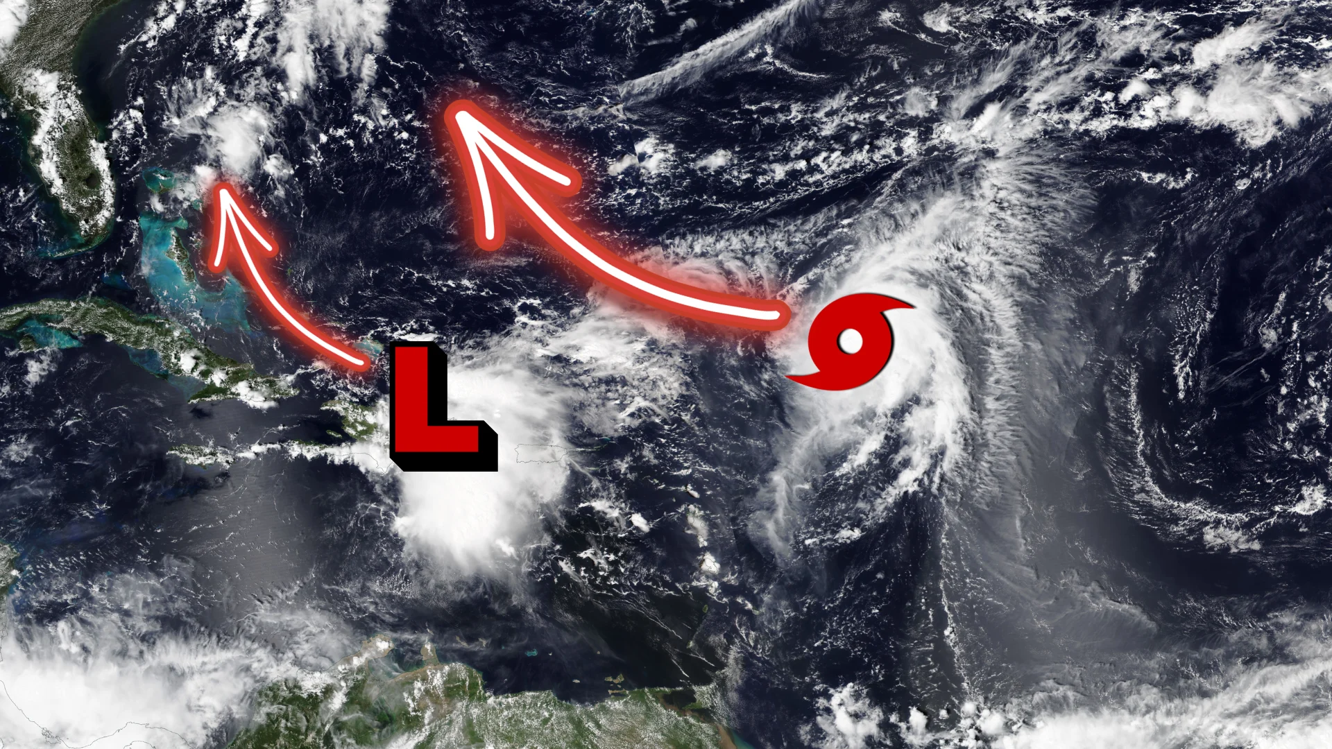
Next disturbance worth watching in the southeastern U.S.
Behind Humberto, our next system is one to watch for the southeastern U.S.

The NHC predicted Thursday afternoon that a tropical disturbance over the Greater Antilles has an 80 per cent chance of developing into a tropical depression by this weekend as it moves through The Bahamas.
RELATED: The high-stakes factors that decide where a hurricane tracks
“While there is significant uncertainty in the long-range track and intensity of the system, the chances of wind, rainfall, and storm surge impacts for a portion of the southeast U.S. coast are increasing,” the NHC said in its Thursday afternoon update.

Any tropical system in this part of the world is unwelcome news as western North Carolina continues recovering from the devastating flooding inflicted by Hurricane Helene last September.
North Carolina Governor Josh Stein’s office reported on Sept. 25 that 95 per cent of public roads damaged by Helene’s flooding have been repaired, and 57 per cent of public bridges damaged during the storm have been repaired or replaced. Crews had removed more than 6.1 million cubic metres of debris from waterways as of Sept. 16.
Stay with The Weather Network for all the latest tropical updates.