
Ontario squeezed into dreary, late-May temperature rut by weather duo
A rather cruel blocking pattern is going to put southern Ontario's weather into a serious rut for late May this week.
Exluding the moments of severe weather, we hope you enjoyed Saturday's pleasant temperatures and periods of sunshine in southern Ontario while it lasted. Things are about to get a lot more dreary, chilly and wet.
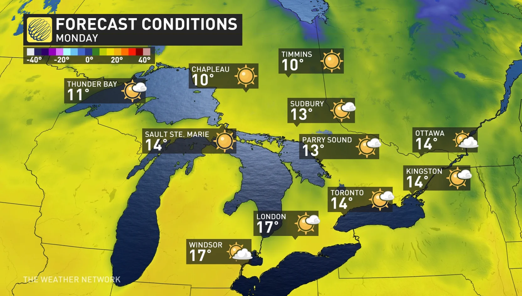
Before the pattern takes a turn, take full advantage of the weather on Monday and Tuesday as conditions deteriorate by Wednesday. You will need to break out the hoodies, jackets and other warm layers of clothing, if you haven't done so already.
DON’T MISS: The pyrotechnic science behind Victoria Day firework displays
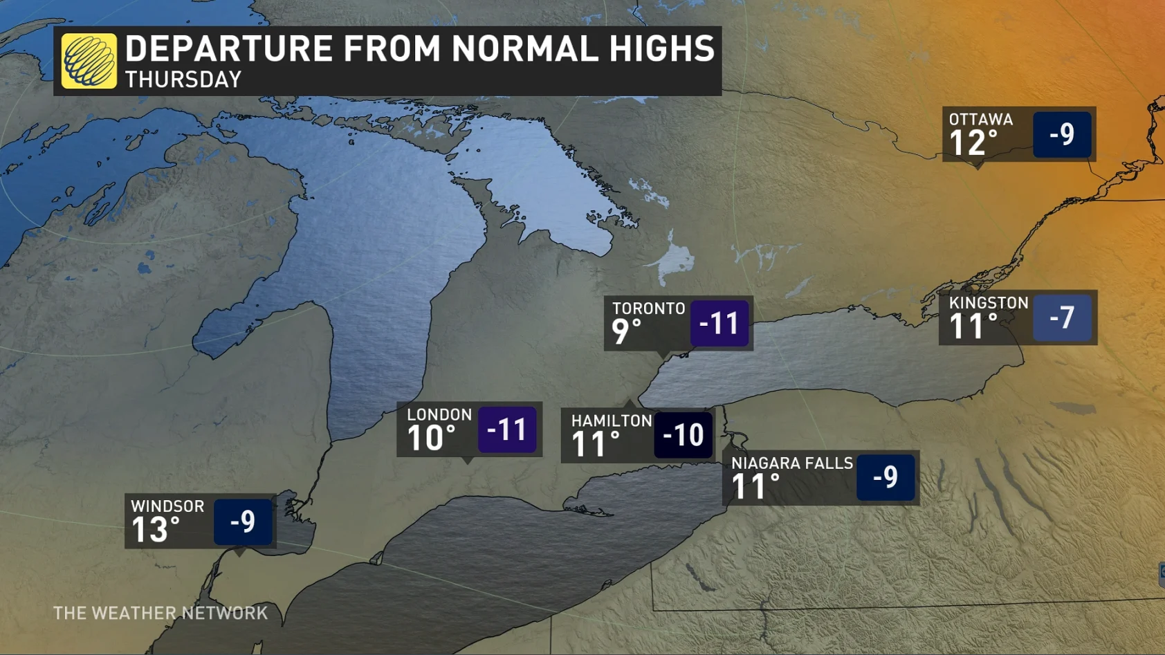
On Wednesday, Ontario will be off the seasonal mark by 10-12 degrees, with northern areas seeing the biggest drop from normal daytime highs for this time of the year. To make matters worse, the chilly temperatures will be accompanied by multiple rounds of rain.
Much cooler-than-seasonal temperatures will then dominate through next weekend and into the following week.
Ontario forced into a temperature rut
High pressure situated in Northern Canada and a stubborn upper trough in the U.S. will join forces to create a significant, late-May temperature rut that will take days to climb out of.
The jet stream, which normally keeps systems moving from west to east, will dive well south--leaving an upper trough detached from the main upper-level winds.
DON'T MISS: Kenora firefighters stay on standby as wildfires blaze in northwest Ontario
On Wednesday, temperatures up to 10°C below seasonal are forecast across southern Ontario, and as much as 12°C off the mark across northeastern Ontario.
If the script was flipped and the anomaly was in the other direction, heat warnings would be issued with temperatures in the low- to mid-30s.
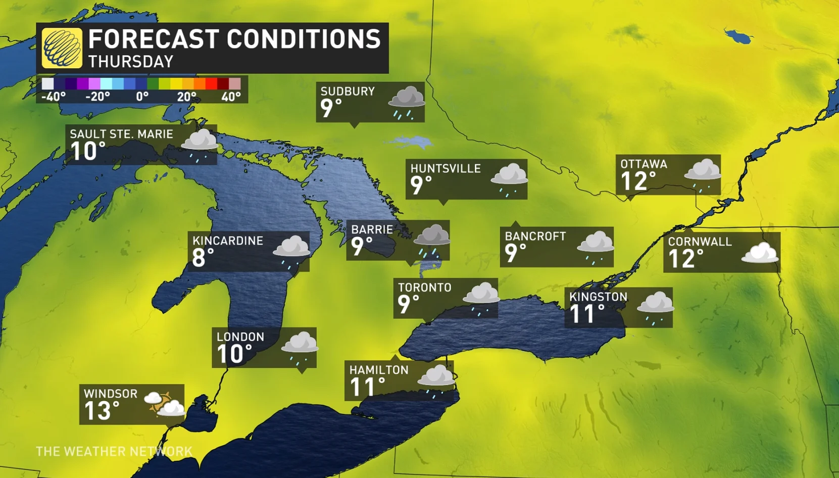
Thursday features similar anomalies with temperatures remaining in the single digits for a lot of the south. We’re not talking sweater weather, more like (rain) jacket weather during this highly anomalous, late-May chill.
Keep in mind, average temperatures are comfortably in the low 20s for this time of year for much of Ontario.
With forecast highs to remain in the single digits on Thursday, it begs the question: What is the latest day in the year we've had highs remain in the single digits across southern Ontario?
You have to go all the way back to May 22, 1967 to find a high that stayed in the single digits in Toronto (9.4°C ), but it’s even been worse. On June 1 and 2, 1945, the high remained just 9.4°C––the latest on record having such a chilly high at Pearson International Airport.
In terms of a reality check, what would be seasonal for this week?
North Bay: 18°C
Thunder Bay: 19°C
Toronto: 20°C
Hamilton: 20°C
Ottawa: 21°C
London: 21°C
Windsor: 22°C
To make matters worse...but some silver linings
To add insult to injury, the surface low will essentially remain at a standstill for more than 48 hours, meaning rounds of rain across the region.
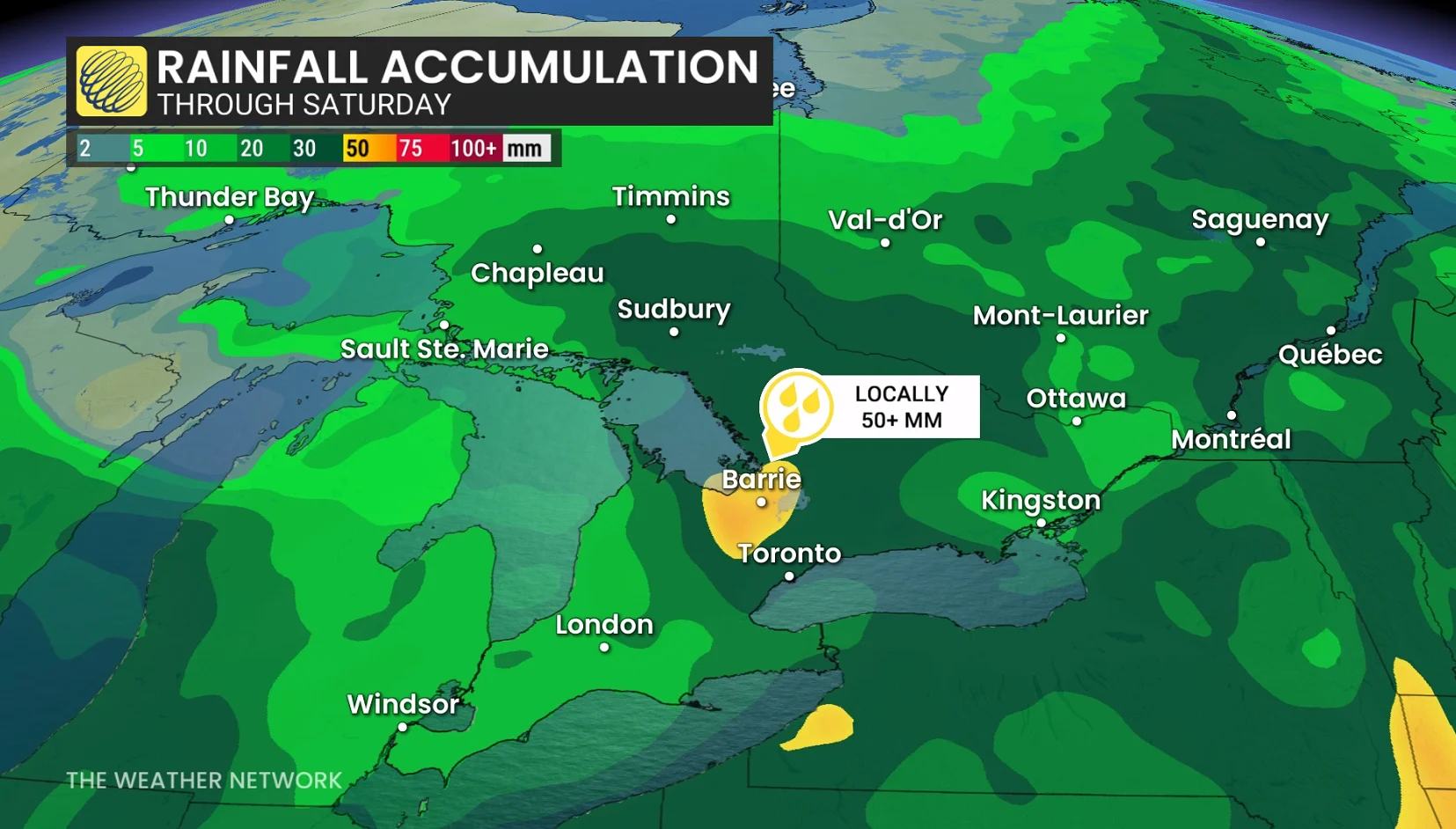
The first impulse of rainfall arrives Wednesday, with steady rates pushing across the region in the afternoon and evening. Heavy showers persist well into Thursday, extending north to cottage country and beyond, with widespread precipitation spilling into Friday, as well.
Rainfall totals through Friday are likely to exceed 50 mm in some locations near and north of the Greater Toronto Area (GTA).
And, for those residing in the GTA, the pesky, easterly wind will further keep temperatures on the cool side in Toronto and other communities adjacent to Lake Ontario. Water temperatures right now are only at 10°C or 11°C.
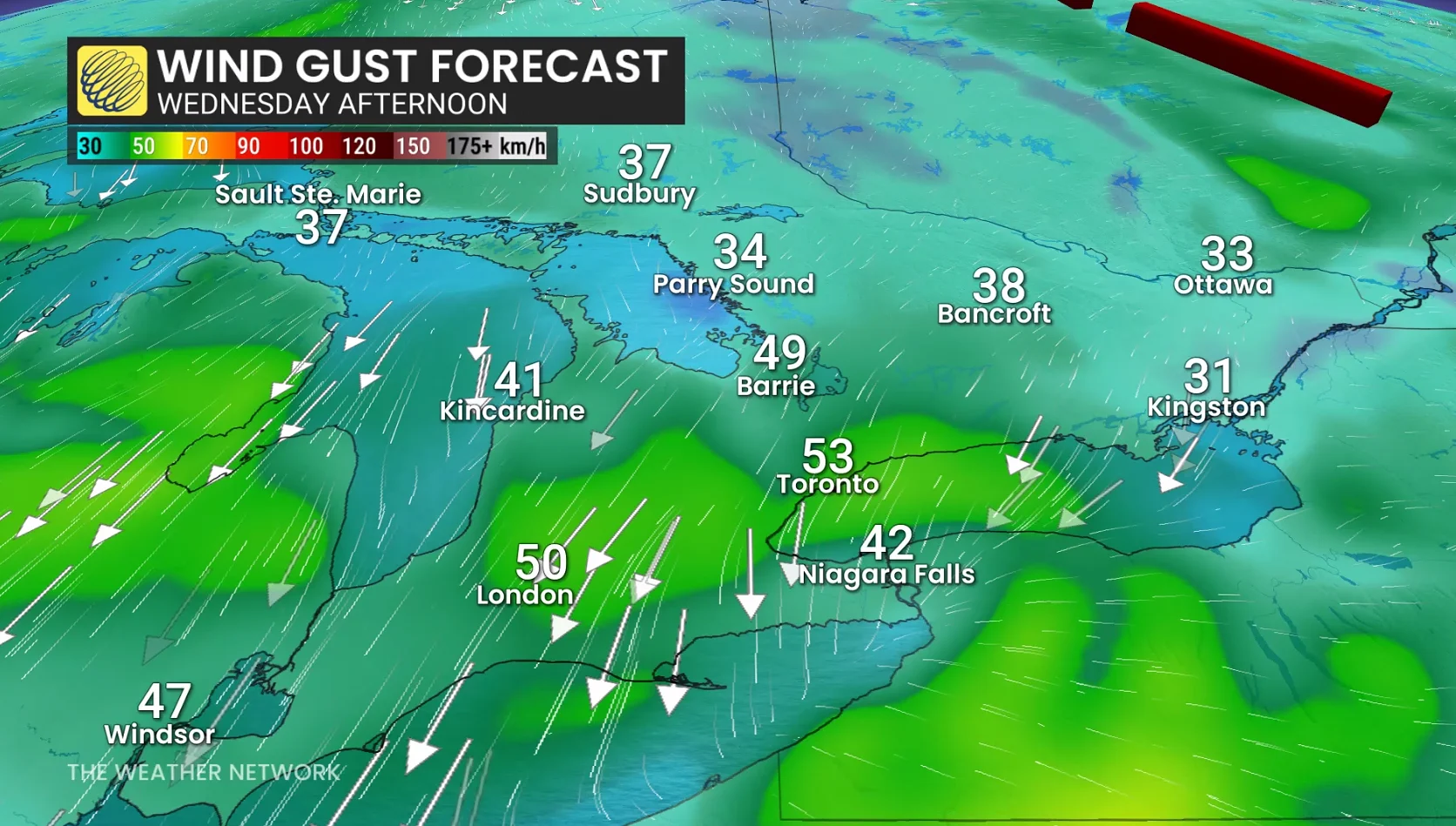
A sustained, easterly wind of 30-40 km/h is forecast, with gusts exceeding 60 km/h is expected during this event, peaking late Wednesday into Thursday morning as the low stalls near Lake Erie.
The situation does come with some silver linings, however. The biggest pro is the steady rain will essentially mean a non-existent drought situation heading into summer. You have to go back to May 2021 to find the last significant drought across southern Ontario at this time of year.
The other positives? A lower sunburn risk with the cloud cover as the sun angle and intensity has been steadily increasing, and for ice cream lovers, there should be shorter lineups.
As well, the rain means water levels in lakes will be healthy, or won't be a cause for concern.
Last year at this time, Lake Ontario’s water level was 74.96 metres. This year, it is just a few centimetres higher, so we’re trending near normal.
If this wet pattern continues into June, a maximum water level of 75.2 metres could be expected to peak in a few weeks.
Finally, with the end of month not far off, the good news is temperatures should trend back to near seasonal as we head into the start of June.
WATCH: Violent storms stretch from Minneapolis to Ontario, Beyoncé concert delayed
Stay with The Weather Network for more information and updates on your weather across Ontario.