Prairies: Heightened threat for strong winds, large hail, and rotating storms
Powerful storms are set to sweep across the Prairies, bringing the risk of damaging 100 km/h wind gusts, hail over 2 cm in size, and heavy rain. We cannot rule out the chance for a tornado or two on both Thursday and Friday
A relentless thunderstorm threat remains locked over the Prairies after several tornado watches and warnings hit parts of Saskatchewan on Wednesday.
The renewed storm risk will be more widespread for Thursday and Friday, with the greatest chance for severe conditions lingering over the Saskatchewan-Manitoba border communities. Heavy rain, strong winds, and large ping-pong-sized hail are the main threats with storms that develop, but we also can't rule out the chance for a tornado or two with the storm risk on both Thursday and Friday.
SEE ALSO: From nuisance to nightmare: Huge hail is an extreme danger
Be sure to monitor local weather alerts and incoming conditions over the next several days.
Thursday: Severe storm risk spreads into Saskatchewan and Manitoba
Scattered thunderstorms persist across Alberta and Saskatchewan on Thursday, with northern Manitoba added to the storm risk, as well.
The chance for severe storms remains in Saskatchewan, though it shifts further east compared to the risk area on Wednesday. Storm activity is expected to develop in the late afternoon hours, and track eastward into the evening.
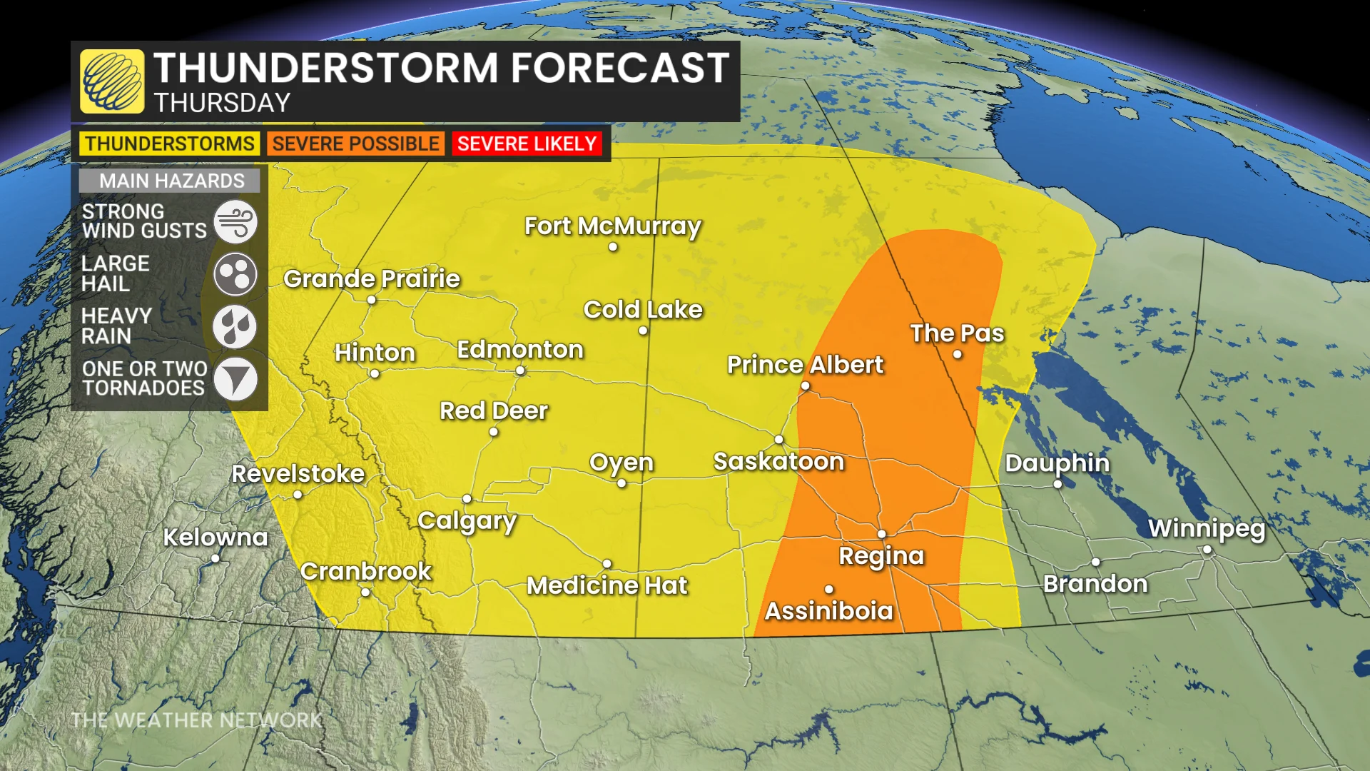
A mix of isolated and linear storms could bring hail ranging from 2–4 cm, potentially reaching golf and ping-pong-ball size. Linear storms could also produce strong wind gusts of 90–110 km/h, particularly in southern Saskatchewan.
DON'T MISS: The Weather Network's new Fire & Smoke map helps you plan ahead and stay safe
Some rotating storms are possible in southern Saskatchewan near dinnertime, increasing the risk for tornado development. However, the primary hazards remain strong winds and large hail.
It will be important to keep monitoring for severe weather watches or warnings.
Friday: Strong storm energy threatens severe conditions
Friday will see another widespread risk of isolated thunderstorms, including hail-producing storms along the Alberta foothills.
The highest thunderstorm energy of the week is forecast for southern Saskatchewan and Manitoba, creating favourable conditions for severe storm development.

A slow-moving trough will interact with the unstable atmosphere, triggering severe storms in southeastern Saskatchewan and tracking into southwestern Manitoba. Areas near Estevan, Sask., and Brandon, Man. could experience 2–5 cm hail and wind gusts of 90–100 km/h.
Forecasters are closely monitoring conditions near the Canada–U.S. border, where rotating storms may develop, bringing the additional risk of tornadoes.
Be sure to stay updated for any severe weather alerts in your area.
Temperatures trend closer to seasonal values by the weekend
After a rather chilly start to the week, temperatures will trend back to near seasonal by the weekend. A warmer pattern will develop next week, with above seasonal temperatures forecast for early July.
DON'T MISS: Canada Day weekend brings changeable summer weather across the country
Western areas are expected to see a few days of drier weather early next week. However, Alberta is likely to experience unsettled, stormy conditions during the latter half of the week.
WATCH BELOW: Can you predict a storm with a straw and a cup?
Stay with The Weather Network for more information and updates on your weather across the Prairies.