
Hail, rain, winds: Nocturnal, severe storm risk in southern Ontario
A line of nocturnal thunderstorms is expected Tuesday overnight into Wednesday morning in southern Ontario. The main threats include frequent lightning, heavy downpours, and the possibility of small or large hail in some locales
Southern and eastern Ontario will experience a mild week, but it will be marked by multiple rounds of thunderstorms and periods of heavy rain.
Tuesday night into Wednesday morning will be a time to be on alert for southern Ontario. Potential impacts include frequent lightning, gusty winds, small-to-large hail, and heavy rain, leading to water pooling on roads, which may affect travel conditions.
DON’T MISS: Forecasters concerned about a growing El Niño this summer
Special weather statements are in effect for southwestern Ontario.
The clash between colder air to the north and mild air in the south is driving this active weather pattern.
Weather Highlights:
Thunderstorms move through the region Tuesday evening and overnight, extending into Wednesday morning. Some could be severe
Chance of heavy downpours, gusty winds, lightning, and small or large hail.
Wednesday and Thursday continue the stormy trend
Water will likely pool on roads and in low-lying areas. Don't drive through flooded roadways
Severe thunderstorm risk with heavy rain, hail and winds in southern Ontario into Wednesday morning
Forecasters are also monitoring the potential for thunderstorms Tuesday evening and overnight, with a chance of severe storms pushing in from Michigan.

Tornado watches and warnings are already unfolding across Wisconsin and Iowa as the threat for strong, damaging thunderstorms are forecast Tuesday evening and through the overnight across the U.S. Midwest.
Stateside, meteorologists are warning of the threat for large hail, damaging winds and multiple tornadoes.
A large cluster of thunderstorms will track into southern Ontario late evening and through the overnight hours.
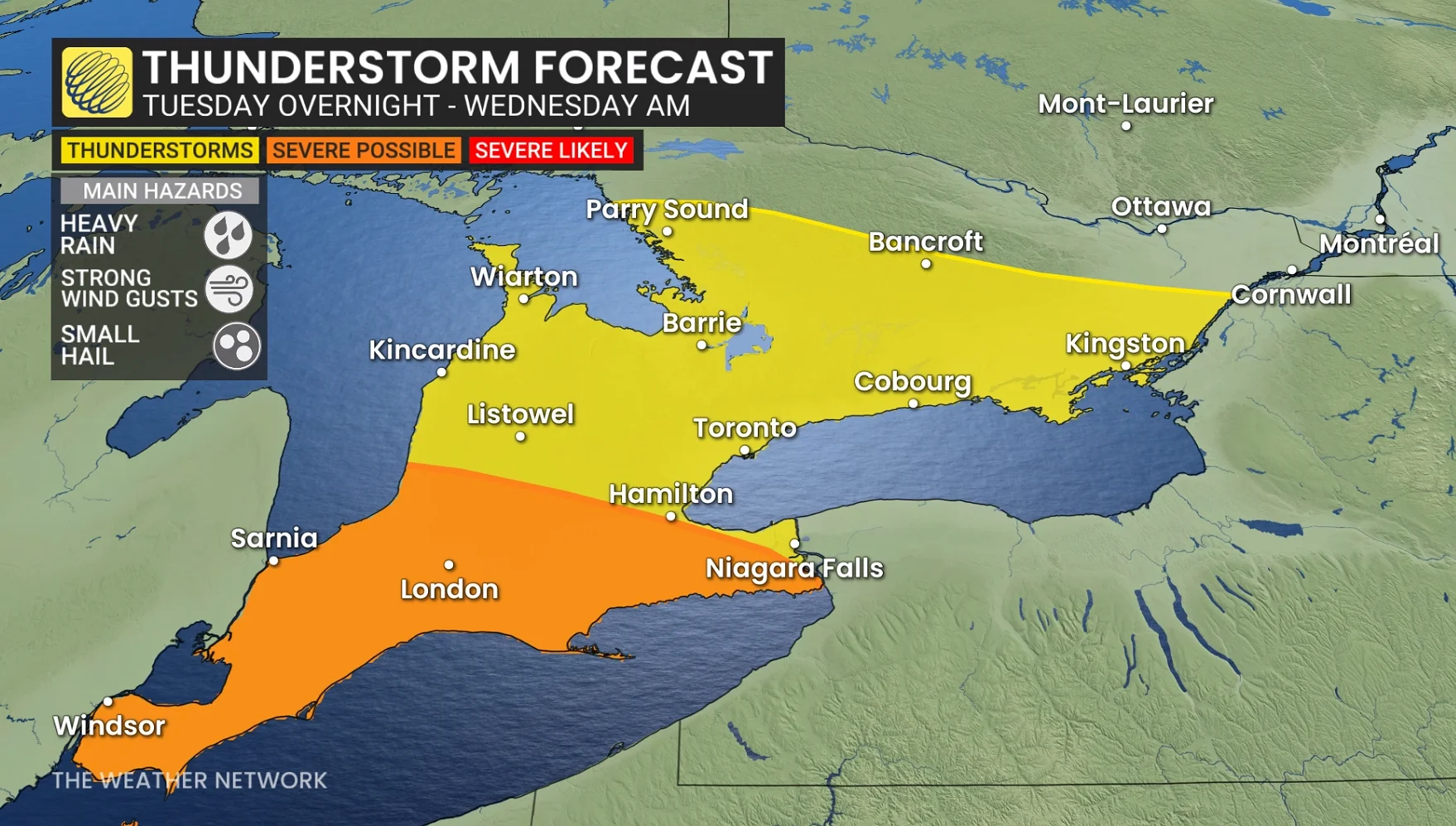
A squall line of thunderstorms is possible for southwestern Ontario, bringing the threat of strong winds and small to large hail.
Frequent lightning and heavy rain are forecast through the pre-dawn hours of Wednesday in southern Ontario.

Special weather statements issued for the chance for localized flooding through the overnight with rounds of thunderstorms.
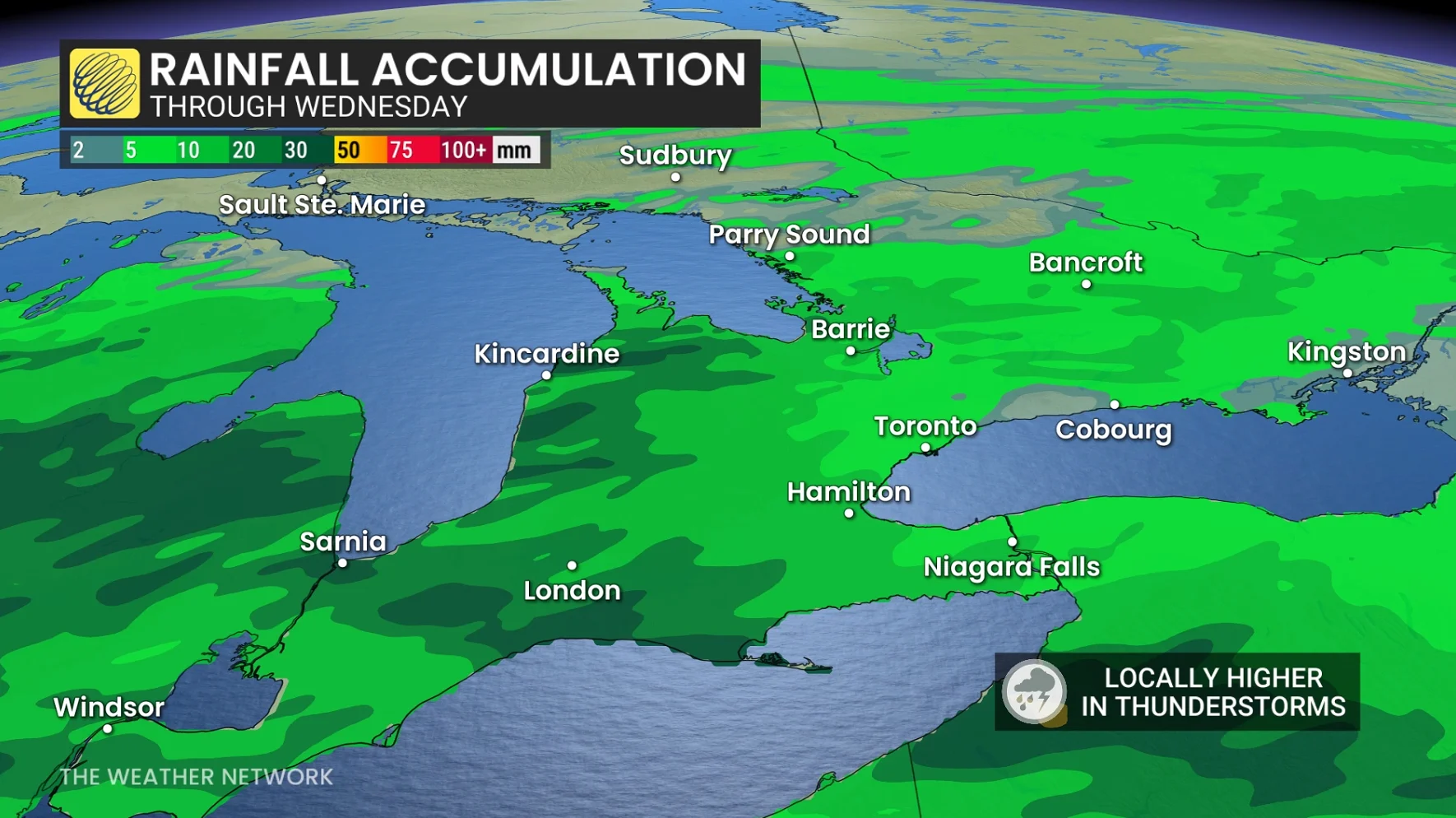
Rainfall totals could reach 30-50 mm near Goderich, London, and Sarnia, with 20-30 mm likely for areas spanning the Greater Toronto Area (GTA) to Niagara.
Conditions remain uncertain for Wednesday afternoon as a warm front may lift thunderstorm ingredients northward. Areas such as Windsor, Lake Erie, and London could see storm development depending on the timing of the front.
If it is delayed, the afternoon and evening may remain cloudy, showery with mild conditions.
WATCH: Early-morning thunderstorm wake-up call in southern Ontario Tuesday
Windsor will try to set another benchmark for the warmest temperature in Canada for 2026, with a high of 28°C forecast.
Thursday: Warm, elevated showers and thunderstorms persist as the warm front shifts northward.
Rain totals for the week could reach between 50-120 mm.
The saturated ground has reduced ability to absorb further rainfall, warns Environment and Climate Change Canada (ECCC), adding that water will likely pool on roads and in low-lying areas.
The Toronto and Region Conservation Authority (TRCA) extended its flood outlook on Monday afternoon, cautioning that heavy rainfall over a short period could lead to localized flooding in affected areas.
Daytime highs soar above seasonal norms
A surge of warm southerly air is set to dominate southern and eastern Ontario this week, with daytime highs reaching the high teens to above 20°C—temperatures more typical of late May than mid-April. Strong southwesterly winds, gusting up to 60 km/h, will accompany this warmth, alongside moisture-rich systems drawing energy from the Gulf of Mexico.
Temperatures will consistently remain 10°C above seasonal norms, with Toronto's Pearson International Airport forecast to record five or six consecutive days near 20°C this week.
Typically, Pearson airport averages fewer than three days above 20°C in April. However, mid-April 2023 saw more intense warmth, with temperatures climbing to 29.4°C on April 12, setting a notable benchmark for this time of year.
Strong winds and temperature drop expected this weekend in southern Ontario
A strong cold front will move across the region Saturday night into Sunday, bringing very windy conditions and a sharp drop in temperatures. By Sunday, daytime highs will hover in the single digits, with flurries expected, including potential lake-effect flurries east of Lake Huron and Georgian Bay.
Early next week is forecast to resemble late March, with changeable temperatures throughout the final week of April. Near-seasonal to cooler-than-seasonal conditions are anticipated to persist into early May.
WATCH: El Niño's role in the 2026 Atlantic hurricane season
Stay tuned to The Weather Network for the latest forecast updates across southern Ontario.