
Significant cross-country storm sweeps much of Canada this week
A significant system is poised to sweep across Canada, bringing active weather as it moves from heavy alpine snowfall in British Columbia through the Prairies, Ontario, Quebec, and into the Maritimes
A powerful low-pressure system is moving across Canada this week, shaping weather conditions nationwide.
Motorists are advised to monitor road conditions and plan routes accordingly as the system moves west to east.
Western Canada
A strengthening low from the Pacific began on British Columbia’s South Coast and Sunshine Coast from Monday through Tuesday, bringing strong winds to Vancouver Island and 40–50 cm of heavy alpine snow to the coastal mountains and the Columbias.

The Lower Mainland, meanwhile, received significant rainfall, with 20-30 mm in Vancouver and 50-75 mm in the eastern Fraser Valley, creating localized flooding risks.
RELATED: Why B.C.'s Coquihalla Highway is a danger in the fall and winter
The storm was accompanied by strong wind gusts of upwards of 100 km/h in some locales, which caused over 53,000 power outages on Vancouver Island Tuesday, with some outages still lingering on Wednesday morning.
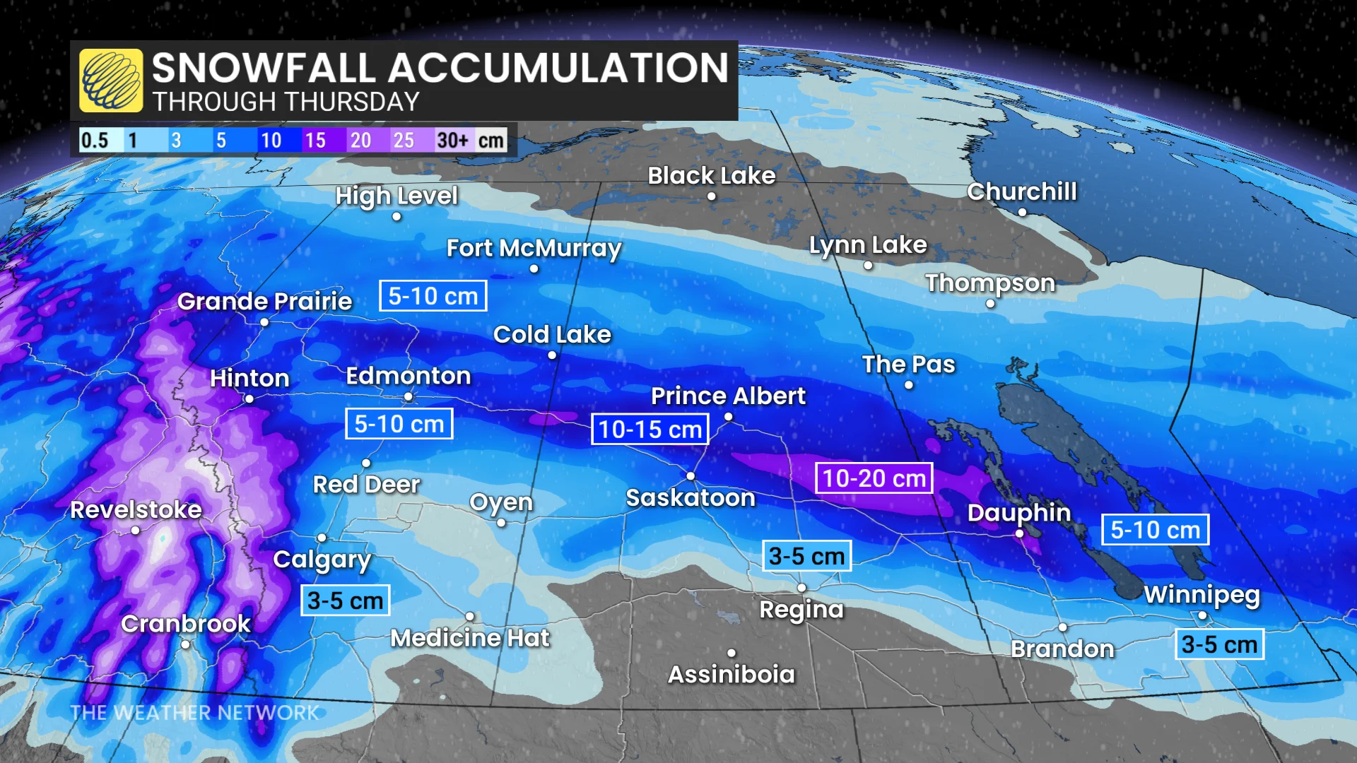
By Tuesday evening, the snow spread into the Rockies and Edmonton, with 5-15 cm of accumulation likely across the Prairies by the end of Wednesday.
Saskatchewan is expected to see the heaviest snow, while cold air could trigger upsloping snow in southern Alberta Wednesday evening.

Measuring accumulating snow in Calgary, Alta., Wednesday morning. (The Weather Network)
DON'T MISS: Are we on the cusp of a “Super El Niño?” Here’s how strong it may grow
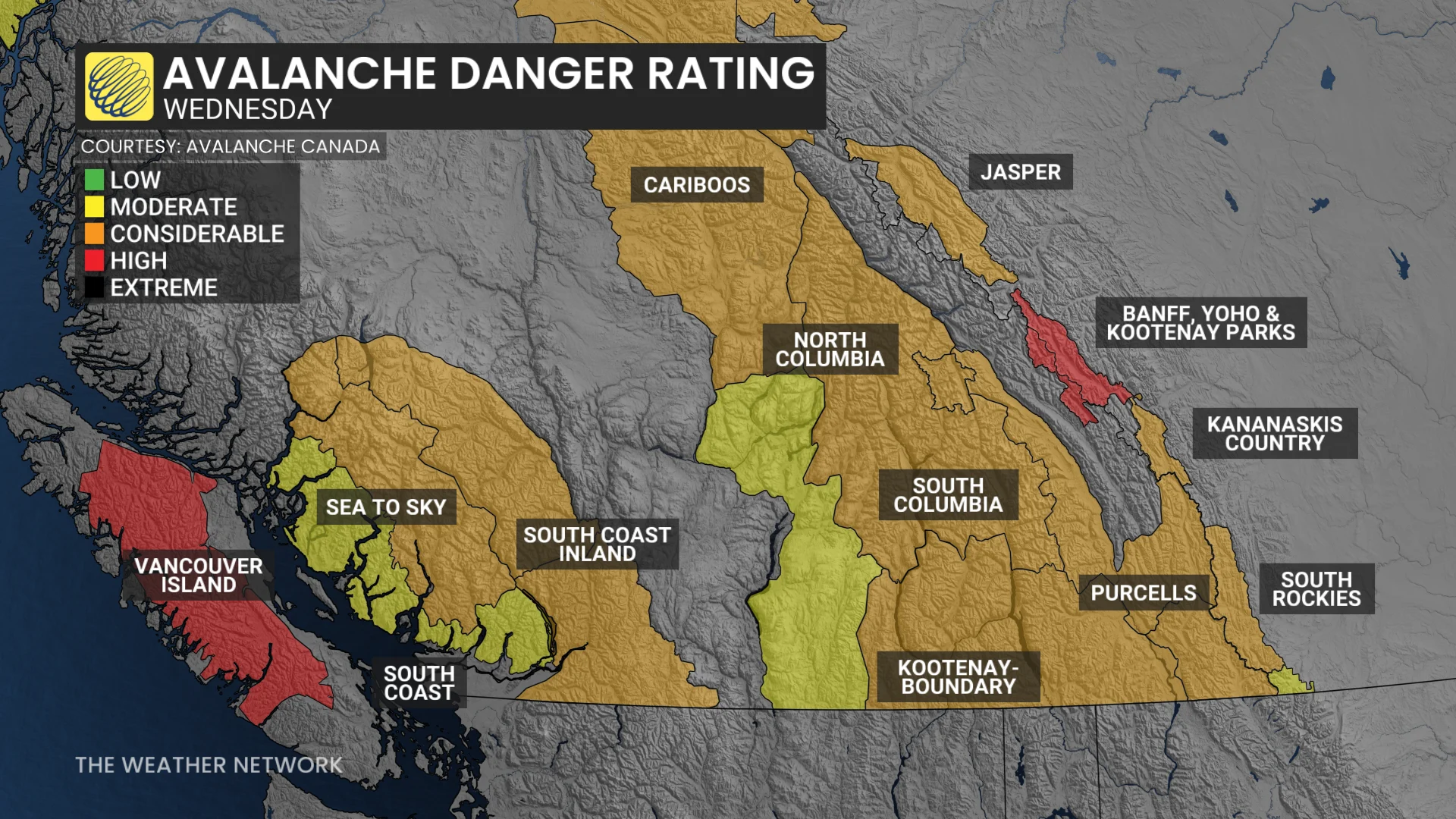
Additionally, experts are urging people headed to the backcountry in the Rockies to use caution as avalanche conditions remain unfavourable following an atmospheric river that drenched the mountains, weakening the snowpacks.
Eastern Canada
The low will bring flurries to northern Ontario on Wednesday, with rain reaching southern and eastern Ontario by Thursday morning.

Ottawa and Montreal could see rain, snow, or a mix, depending on the storm’s track.
Temperatures will drop below seasonal levels on Friday, struggling to exceed 0°C in Toronto. Wind chills could push Ottawa and parts of the snowbelt below -10°C.

The system will wrap up in Atlantic Canada on Friday, bringing heavy snow and rainfall. Further details on precipitation type and location will depend on the storm’s exact trajectory.
A cooldown will follow into Saturday.
Areas of focus this weekend into next week
During the weekend and into next week, the focus of the frigid weather will shift east, especially from Hudson Bay to Atlantic Canada. Meanwhile, Western Canada will trend closer to seasonal.