Smoke set to return as hazardous heat settles over Ontario
This is shaping up to be the warmest July in five years for much of southern Ontario
Summertime remains firmly in control for the closing days of July as muggy heat blankets portions of Ontario for the next several days.
Heat warnings are in effect as the dangerous combination of high heat and excess humidity could lead to heat-related illnesses in short order.
Forecasters are also monitoring the potential return of smoky conditions across parts of southern Ontario to start the new workweek.
DON’T MISS: Why extreme heat is one of the world’s deadliest weather disasters
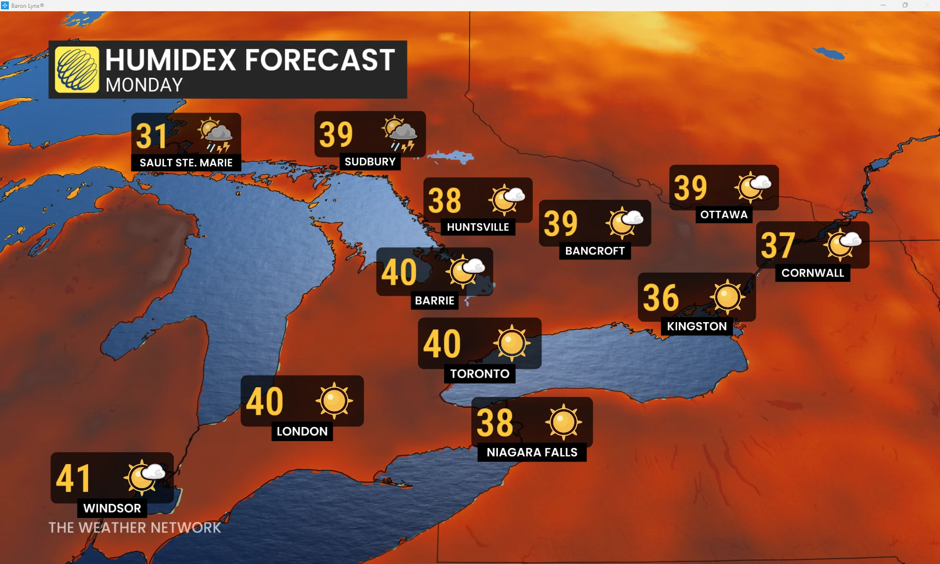
Dangerous heat persists for several days in spots
We’re in the midst of Ontario’s fifth multi-day heat event of the season. Daytime high temperatures will hover between 30 and 34 degrees on Monday, with feels-like values ticking toward 40 when you factor in the excessive mugginess.
The humidity will prevent nighttime temperatures from dropping below 20 degrees in many locations, preventing any meaningful heat relief after sunset. Smoke and haze may keep daytime temperatures a tad lower in some locations, depending on their concentration.
Heat affects everyone. Vulnerable people are especially susceptible to heat-related illnesses, including those with chronic health conditions and folks living without air conditioning. Be sure to check on your elderly family, friends, and neighbours.
A cold front pushing into Ontario will lower temperatures in a hurry as the week progresses. Central Ontario could see temperatures fall by Monday night, while the heat will persist until Wednesday across southern Ontario until the boundary slides south across the region.
Warmest July since 2020
This is shaping up to be the warmest July in five years for many cities in southern Ontario. Toronto-Pearson has seen an average high temperature this month of 29.2°C, with Ottawa clocking in with an average of 27.9°C.
RELATED: Canadian heat waves far more likely in the era of climate change
Mean temperatures—averaging together the day’s high and low—above 24°C have become more common in recent decades for Toronto. Since 1999, the city has seen six Julys with temperatures above that threshold. Before that, the city only experienced that level of heat once in 1955.
Smoke set to return to portions of Ontario
Wildfires continue to burn on the Prairies and in the western United States.

Various smoke models indicate that thick smoke and haze will spread across eastern Ontario, including Ottawa, by Monday morning.
Folks across northwestern Ontario will experience increased smoke concentrations on Monday, and fine particulate matter is expected to cover most of the province and linger into Tuesday.
If you’re sensitive to smoke, plan ahead for any disruptions to outdoor activities to start the week.
Header image created using graphics and imagery from Canva.
Stay with The Weather Network for all the latest on conditions across Ontario.