Southern Ontario to get early winter taste with 5-10+ cm of snowfall
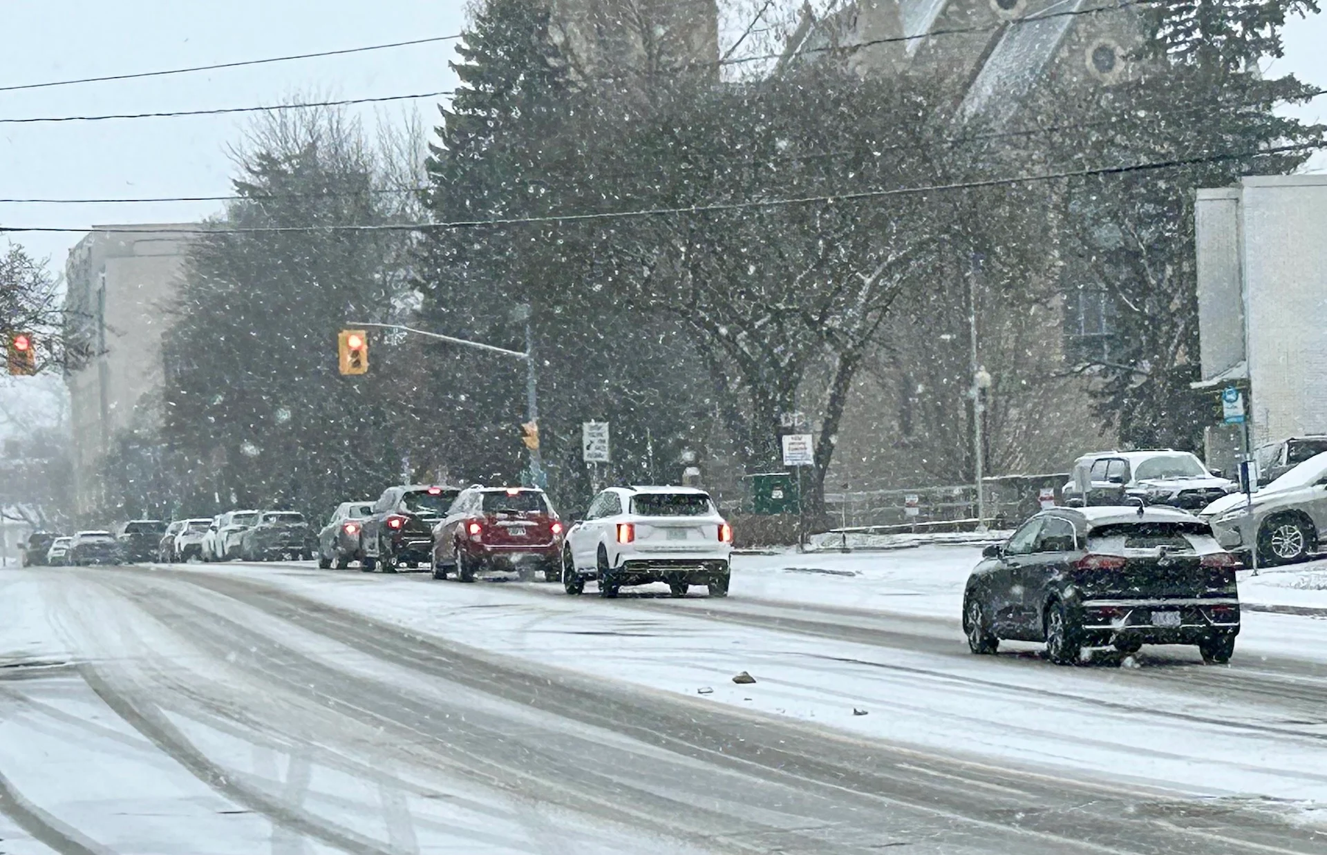
All eyes are on Sunday’s forecast as much of southern Ontario prepares for a system that will bring parts of the region their first accumulating snowfall of the season. With 5-10+ cm expected, exercise caution on the roads, especially without winter tires on
While the official start to winter is more than a month away, Mother Nature certainly isn't wasting any time giving southern Ontario a taste of what's to come.
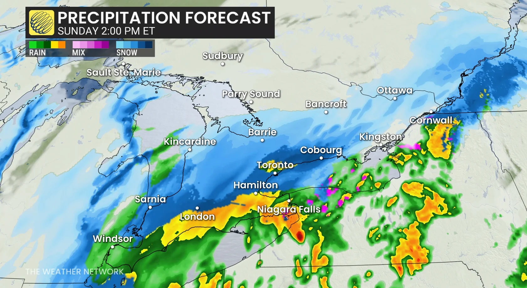
A system will track south of the region to bring a notable amount of snowfall for a swath of the region, expected to bring anywhere from less than 2 cm to as high as 20 cm in eastern areas.
RELATED: Why the first snowfall of the season can catch drivers by surprise
Prepare for slick roads and tricky travel Sunday into Monday, especially without winter tires, as many Ontario communities (but not all) are seeing first accumulating snow of the season. It is important to note that accumulations will be limited to grass and untreated sidewalks. Roads could see initial melting on contact.

While it's still the beginning of November, so these early-season snowfalls remind residents to prepare for shifting driving conditions and ensure vehicles are winter-ready. Residents are advised to monitor any developing weather alerts and to prepare for potentially slippery roads and reduced visibility in affected areas.
Sunday: Snow dependent on storm track and temperatures
Modified Arctic air will be pulled behind a system tracking south of the region Sunday morning and afternoon.
Forecasters are increasingly confident that this will be a mostly wet-snow event down to Lake Ontario’s shoreline as temperatures will hover just above freezing as the precipitation falls.
DON'T MISS: Winter-proof your home with a heat pump that even works in -30°C
Mixing is likely near the shoreline of Lake Ontario, limiting snowfall accumulations near the water. Lots of mixing and even a transition to rain for Lake Erie and the east end of the Niagara Peninsula as warmer air is drawn north.
The initial wave of precipitation will arrive early Sunday morning. A period of heavier and steadier snowfall should begin as the system draws closer by the late morning, continuing into the late afternoon and evening hours for many areas.
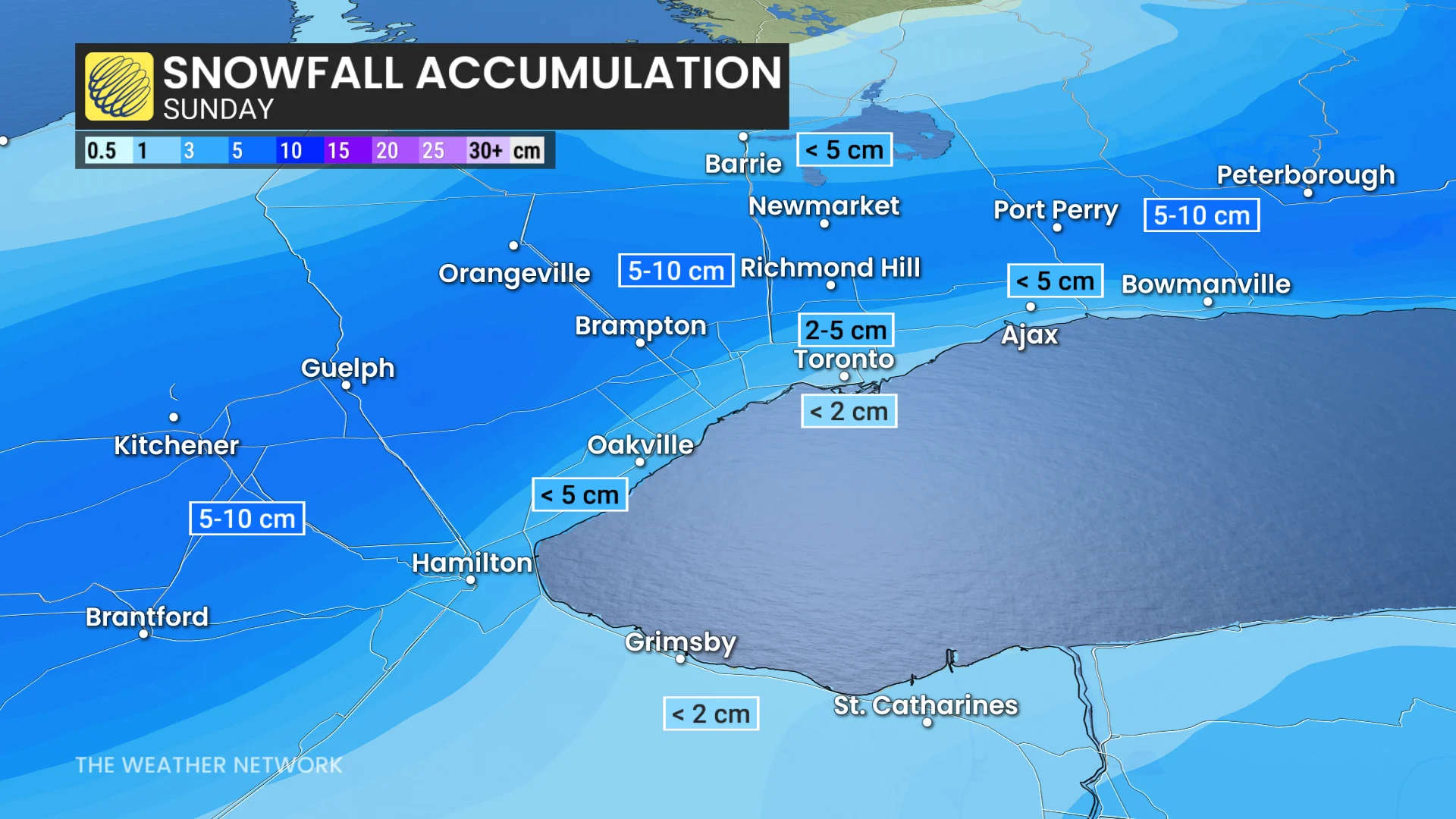
Through the event, the heaviest-hit regions in higher elevations and near the 401 and 407 could see 5-10 cm of snowfall. Any region that sees sustained, wet snow through Sunday evening has the potential to accumulate close to 10 cm of snow by Monday morning. Residents without winter tires should exercise caution.
Areas from the Greater Toronto Area (GTA) to the Niagara region is forecast to generally accumulate less than 5 cm of snowfall, with the lowest amounts near the lakeshores.
Regions north of the GTA will naturally accumulate snowfall including areas such as Milton, Guelph, Brampton, Richmond Hill, Newmarket: All which are likely to accumulate more than 5 cm of snowfall.

DON'T MISS: Toronto to go dark again as it nears final 5 p.m. sunset until 2026
As the system continues to track east, regions that transitioned to a wintry mix will have the opportunity to transition back to heavy, wet snow Sunday evening–including Hamilton and Niagara (5+ cm is possible). That part of the forecast is the least confident, but needs to be monitored carefully.
Heavy snow is forecast to move into eastern Ontario by early Sunday evening, giving some of the highest snowfall totals for the province.

A deeper supply of colder air means Ottawa's precipitation will remain as snowfall for the duration of the event, with a wintry mix through the evening and overnight near and along Highway 401 between Kingston and Cornwall.10-20 cm of snow is forecast across extreme eastern Ontario, with lesser amounts farther north and west.
It’s important to note that accumulations will be limited to grassy areas and untreated sidewalks. Temperatures close to or below 0°C Sunday morning and afternoon will support potential snow-covered or icy roads, increasing the risk of slow driving conditions.
A sharp cutoff of snowfall accumulation is expected in some regions.
Lake-effect snow chances increase early next week
Following the system, persistent Arctic air will drive multiple days of lake-effect snow in the traditional snowbelt regions on Monday and Tuesday.

RELATED: Do the warm Great Lakes mean lots of snow this winter?
A wintry December is coming
Temperatures early next week will remain chilly, with values struggling to reach the low single digits near and south of the 401, while staying below freezing in areas well north of the 401.
A gradual temperature rebound is anticipated later in the week, with above-seasonal conditions expected as the region moves into the second half of November. However, more consistent winter weather is anticipated to settle in before the start of December, with December shaping up to feature decidedly wintry conditions.
Safety tips for driving in adverse weather
Install winter tires. Winter tires can improve stopping distance by up to 30 per cent in wintry conditions.
Prepare an emergency kit. Include the basics like snacks, first aid kit, flashlights and blankets.
Plan your travel. If possible, postpone trips during active weather and especially freezing rain. Driving is not worth the risk.
Adjust your speed. A gentle reminder that stopping distance increases exponentially as your speed increases.
Header image created using graphics and imagery from Canva.