Storms threaten to interrupt the weekend in parts of Ontario, Quebec
A sprawling cold front will make for a stormy weekend for parts of Ontario and Quebec, including parts of cottage country.
August is coming to a close and cooler temperatures have made their way to Eastern Canada after a brutal stretch of scorching temperatures and sunshine. But while temperatures may be more suitable for spending time outside, a weekend storm risk may still be keeping folks inside.
Both Saturday and Sunday will feature a storm risk in Ontario and Quebec, with severe storms possible both days. Folks spending the weekend camping or at the cottage should keep an eye on the radar and local weather alerts throughout the weekend.
DON'T MISS: Surprising tornado deficit continues across Ontario, Quebec
Saturday:
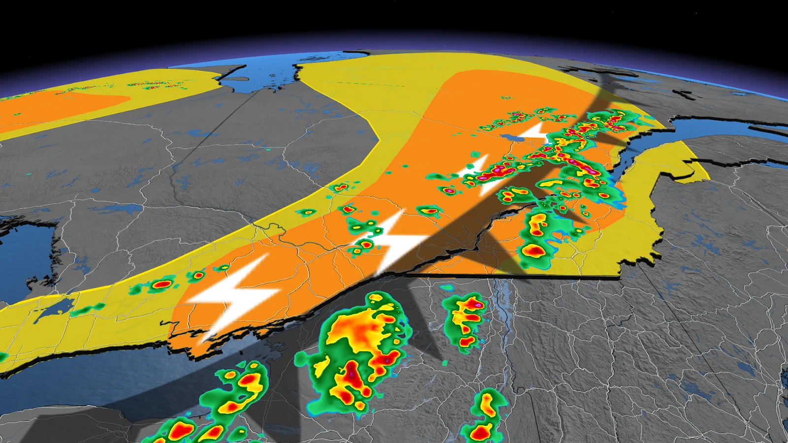
Storms are expected to fire up by Saturday afternoon between Lake Superior's eastern shores in Ontario and the Val d'Or area in Quebec. We could see some storms become strong at times within this region through the afternoon. Storms may also intensify north of Timmins and toward the James Bay shorelines.

Heavy downpours and small hail will be the main risks throughout the day with these storms. We may also see conditions become favourable in Quebec for some storms to have rotation.
Further south, a line of thunderstorms is forecast to sweep over Grey County and Bruce County in the mid-afternoon.
Folks spending the weekend in Ontario's cottage country may see some stormy weather roll in off of Georgian Bay by the evening hours. There is also a chance for some of these storms to reach severe criteria.
While the main storm risk stays north of the Greater Toronto Area, a passing shower or two may still put a minor disruption on the day throughout southern Ontario.
Saturday's risk will miss the Ottawa Valley and Laurentians, but the regions won't be in the clear for the whole weekend. A renewed storm risk on Sunday will target eastern Ontario and southern Quebec.
Sunday:
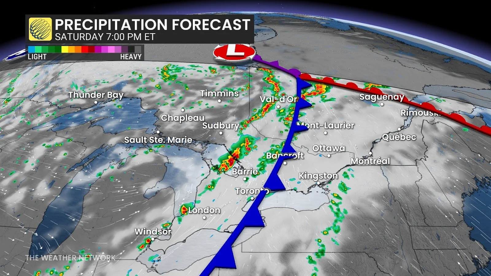
As the cold front continues to move northeast, so too does the storm risk on Sunday.
By Sunday morning, the front will be over the St. Lawrence Valley, bringing a heightened storm risk that stretches from Ottawa to Saguenay.
SEE ALSO: Is that it for the summer heat? Sweater weather ends August across Ontario
Ottawa will have the chance to see multiple rounds of strong storms in the early afternoon, with heavy downpours and large hail being the primary threats.

Montreal may also hear a few rumbles of thunder late in the evening, along with some heavy showers, but storms are likely to stay non-severe.
Showers will continue to accompany the moving cold front through the overnight hours, eventually moving into Atlantic Canada.
Looking ahead:
Temperatures across Ontario will dip below seasonal heading into next week, giving folks a taste of autumn.
Some showers are expected across the province throughout the week, helping to relieve southern Ontario of its summer drought and fight against wildfires in northern Ontario.
Southern Quebec will see temperatures begin to cool down by Tuesday, but folks may be getting a few more showers and rumbles of thunder before that happens.
Stay with The Weather Network for more information and updates on your weather across Ontario and Quebec.