
Strong winds prompt warnings in Ontario, risk of outages and high waves
Hold on: Wind warnings issued for parts of the province as strong gusts pick up throughout Friday
Thursday's rain and storms across parts of Ontario will transition to windy conditions on Friday, driven by an intensifying low pressure system.
Wind warnings and special weather statements have been issued, with gusts of up to 90 km/h possible in certain areas. Residents are urged to secure loose items and anticipate rough conditions on local lakes.
DON’T MISS: Keep your furniture from flying around in strong winds with this simple hack
Be sure to stay up-to-date on all of the weather warnings and alerts in your area through Friday.
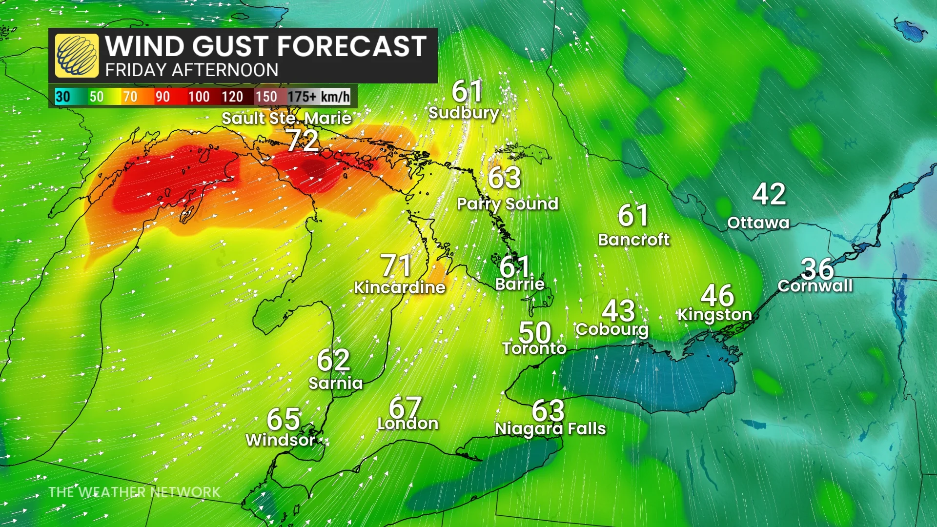
Wind gusts of 70 to 90 km/h possible Friday
A large, stationary low over Hudson Bay will direct a secondary low into northeastern Ontario, bringing impactful weather to the region.

The system is set to deliver strong winds and heavy rain on Friday, followed by lake-effect precipitation and a notable cooldown on Saturday. The heaviest rainfall is expected in northeastern Ontario during the afternoon, with the possibility of severe thunderstorms near Sudbury and North Bay.
These storms could bring 70-90 km/h winds, heavy rainfall, and small hail.

While most of the rainfall will remain north of cottage country, windy conditions are expected to spread into southern Ontario throughout Friday, with gusts reaching 60-70+ km/h.
Secure loose objects like decorations, potted plants, and trampolines—all of which can easily blow around in gusty winds.
Choppy waters and elevated wave heights are also anticipated across the Great Lakes.
Lake Huron, particularly off Bruce County, could see waves reaching up to 3 m. Meanwhile, Georgian Bay and the shores of Lake Erie may experience waves reaching up to 2 m. Boaters and those near the water are advised to exercise caution.
This weekend: Feel the autumnal chill
Lingering rainfall is anticipated near Lake Superior and Georgian Bay this weekend, driven by residual instability.

Weak instability will be enhanced by the Great Lakes, allowing bands of lake-effect showers to potentially persist into Saturday morning.
Below-seasonal temperatures are forecast across Ontario for Saturday and Sunday as the departing storm draws in cold northern air.

Residents can expect cooler mornings, with daytime highs reaching the low to mid-teens in northeastern Ontario, and the high teens to near 20°C in southern and eastern regions. For comparison, Toronto’s seasonal daytime high is 23°C.
Is the fall weather officially here to stay? Find out more in our 2025 September outlook.