Canada's 2025 summer forecast spotlights heat dome and ring of fire

After a long winter and a sporadic spring, will we be rewarded with a warm and sunny summer to enjoy our favorite outdoor activities? Find out as we unveil Canada's 2025 summer forecast!
It’s time to get out and explore Canada’s great outdoors!
Canadian summers truly are fantastic opportunities to enjoy our country’s spectacular scenery with our extended daylight hours. The one wild card is always the weather!
After a long winter and a sporadic spring, will we be rewarded with a warm and sunny summer so that we can enjoy our favourite outdoor activities?
According to The Weather Network’s summer forecast, the upcoming season will truly deliver for those who have been longing for warmer weather. We expect that most of Canada will experience temperatures that are warmer than normal during the months of June, July, and August.
Canada’s summer temperature forecast: Above normal heat
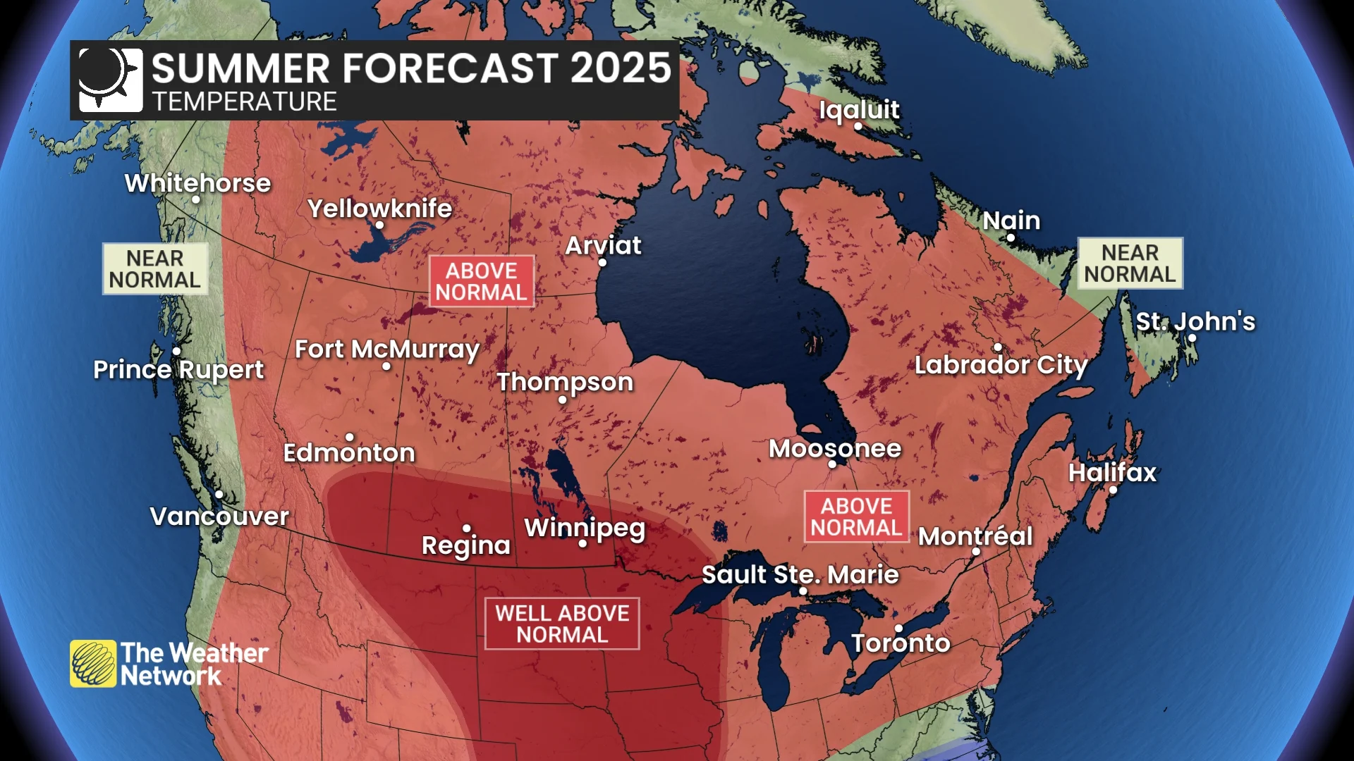
National temperature forecast for this summer. (The Weather Network)
While most of Canada will experience a warm summer, we are highlighting the potential for temperatures to be much warmer than normal across parts of the country (especially during July and August), stretching from the Rockies to northwestern Ontario. Those areas face a risk of extended heat waves and a few days of extreme heat. The excessive heat could also occasionally extend into British Columbia, but we do not expect it to be as persistent there as it will be across the Prairies.
In Eastern Canada, from the Great Lakes to Atlantic Canada, we anticipate a warm and humid summer. While a few heat waves are possible, we do not expect persistent or extreme heat. For most of the region, high temperatures should be near normal or slightly above normal, but nighttime temperatures are forecast to be warmer than normal due to the muggy conditions.
Canada’s summer precipitation forecast: Drought and storms
We expect this summer to feature below-normal rainfall across most of Western Canada. While extended stretches of sunny and dry weather may sound ideal, too much of a good thing can also lead to serious concerns.
A heat dome is expected to be a persistent feature over the central United States during July and August. We anticipate that this will result in widespread drought across that region, and we are concerned that drought conditions will expand north of the border, particularly across the southern Prairies, with the potential for significant impacts on agriculture.
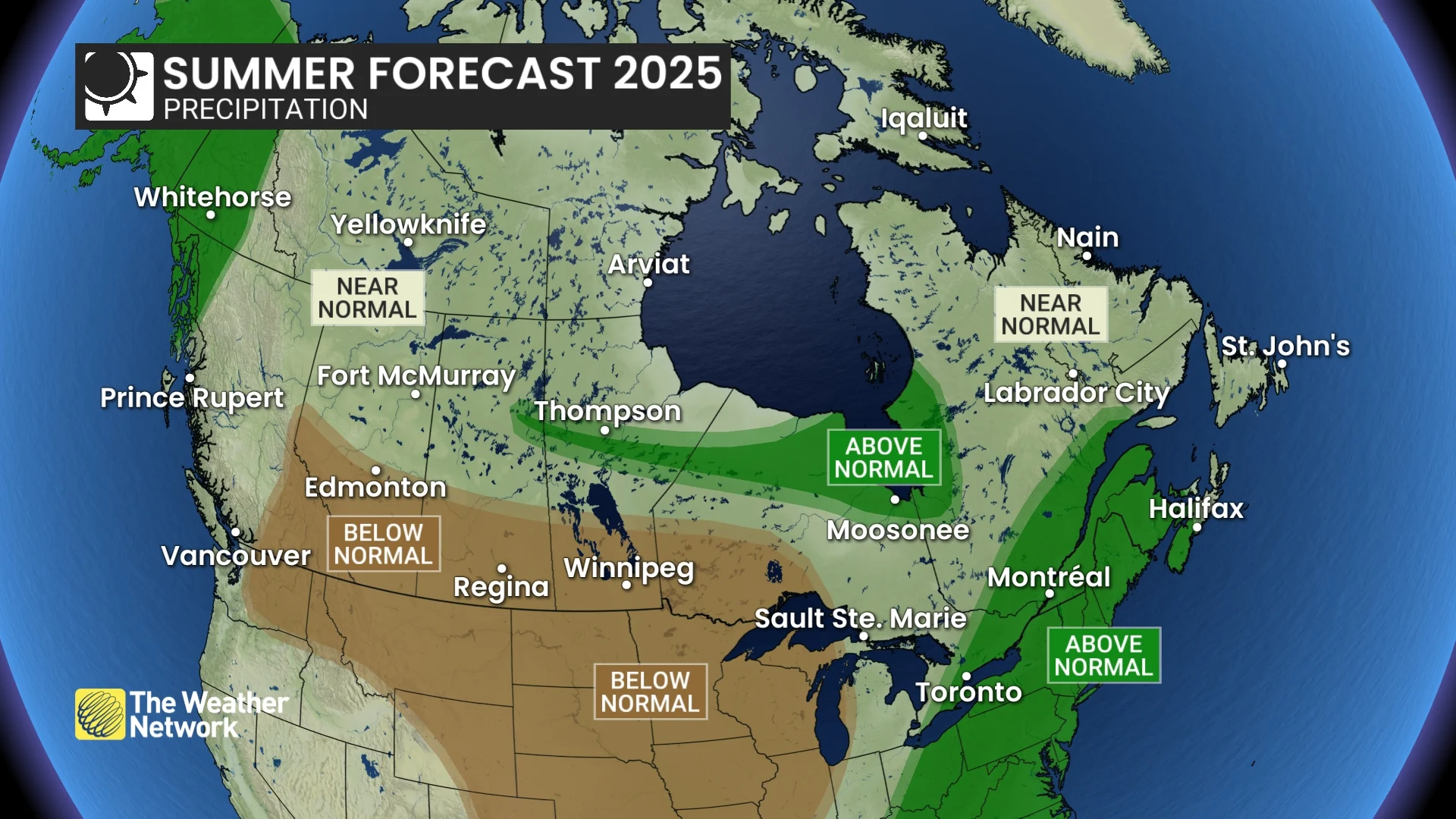
National precipitation forecast for this summer. (The Weather Network)
RELATED: What is a heat dome and how does it really work?
To the north of the drought areas there will be frequent thunderstorms, including a threat of strong to severe storms with localized torrential rain. This weather pattern with thunderstorms that develop and track around the edge of the heat dome is often referred to as the "ring of fire."
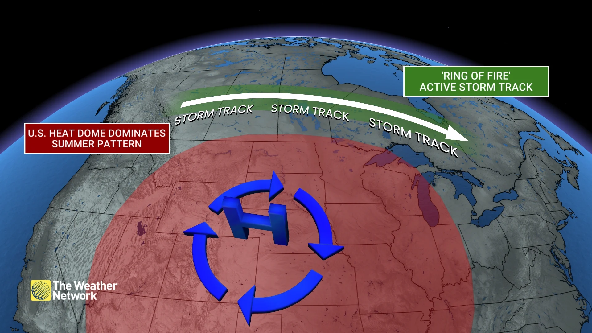
There is considerable uncertainty regarding which parts of the Prairies will be affected most by these regular storms. However, the rain is not expected to be widespread enough to mitigate the threat of wildfires. We are also concerned about wildfires across much of British Columbia and northwestern Ontario.
Eastern Canada could experience periods of dry weather, but we do not expect widespread or prolonged drought conditions this summer from east of the Great Lakes to Atlantic Canada. That region will see more frequent showers and thunderstorms, with a risk of strong to severe storms and torrential downpours at times.
However, keep in mind that summer thunderstorms are notorious for being localized, and we often see areas that repeatedly miss out on rain in close proximity to places that have a surplus.
Below is a more detailed look at what we can expect across the country during the upcoming summer season:
British Columbia
A hot summer is anticipated across the interior of the province, including Kelowna and Kamloops, particularly during July and August. However, temperatures should trend closer to seasonal averages near the coast, including Vancouver and Victoria.
Rainfall totals are forecast to be below normal or near normal across most of the province, so the threat of wildfires, smoke, and poor air quality will increasingly concern us as we progress through the season. Keep in mind that summer is the driest time of year in B.C., so even normal precipitation combined with hot temperatures is insufficient to prevent a significant fire danger.
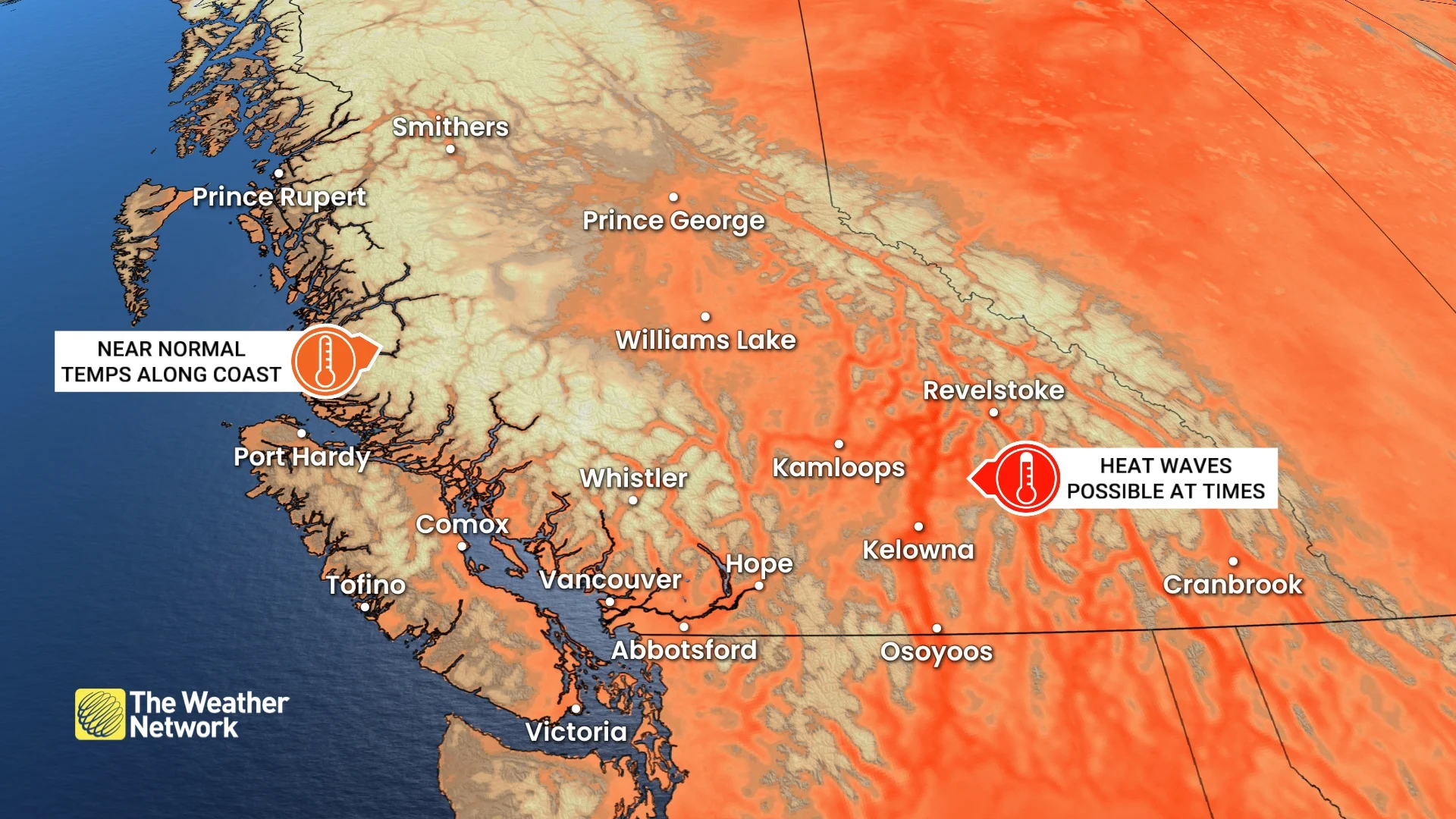
At this point, we expect the hottest weather this summer to be focused to the east of B.C., but we are concerned that it may expand west into the province at times. If the heat does remain concentrated to the east, then showers and thunderstorms will be more frequent and widespread across the province than our current forecast suggests. If it occurs, it would provide significant relief from the dry conditions.
Alberta
A hot summer is forecast for the province, including Edmonton and Calgary, especially during July and August. That includes a threat of extended heat waves and a risk of extreme heat at times.
Widespread drought is a major concern this summer, particularly across the southern half of the province, with a risk of significant impacts on agriculture. Wildfires, smoke, and poor air quality are also concerns.
While much of the province is expected to receive below-normal rainfall, thunderstorms will still occur at times, especially in the central and northern parts of the province, bringing the typical threat of severe storms, localized torrential rain, and hail.
Saskatchewan and Manitoba
A hot summer is expected across the region, including Saskatoon, Regina, and Winnipeg, especially during July and August. That includes a risk for extreme and extended heat waves at times.
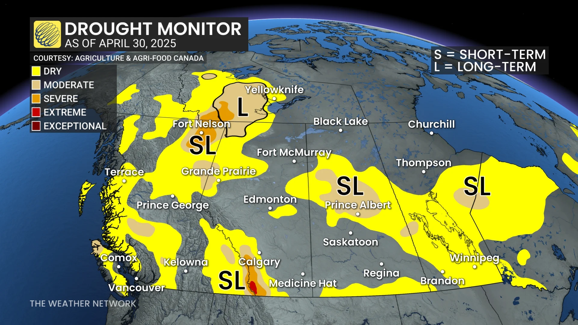
Widespread drought is expected this summer across the central United States, and we are concerned that the drought will extend well north of the border and impact at least the southern Prairies, with a risk for a significant impact to agriculture. Wildfires and smoke are also potential concerns.
However, powerful thunderstorms will provide some relief from the dry weather at times, with a risk for severe storms and localized torrential rain, especially for central and northern parts of the region.
Northern Ontario
A hot and dry summer is expected across western parts of the region, especially west of Lake Superior, including Thunder Bay. To the east of Lake Superior, including Sudbury, we expect that temperatures will be warmer than normal, but we should see more humidity across this region. That will contribute to a higher threat for showers and thunderstorms and muggy nights, but daytime temperatures will not be as hot as what we will see to the west of the region.
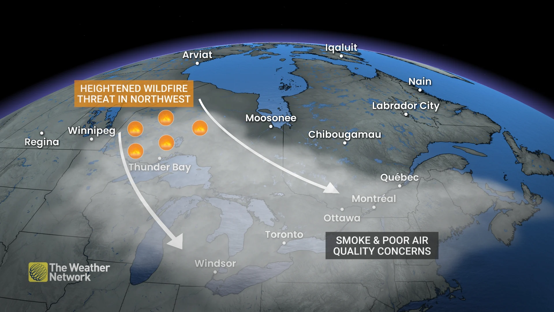
The threat of wildfires is a major concern across northern Ontario, especially to the north and west of Lake Superior. If this threat is realized, the fires could have a far-reaching impact on the other parts of the country with smoke and a risk for poor air quality at times.
Southern and eastern Ontario
After a sluggish and sporadic spring, a warm and humid summer is expected across the region, including London, Toronto, and Ottawa. Early June will feature a quick transition to a much warmer pattern, and we could see our first heat wave before Canada Day.
However, we do not expect persistent or severe heat throughout the summer. A few cool fronts will track across the region and deliver periods of more refreshing conditions. The higher humidity is forecast to keep overnight temperatures significantly warmer than normal, but daytime high temperatures are expected to be near normal or just slightly above normal.
We should experience stretches of drier weather during the summer, but we do not expect widespread or prolonged drought in this region. The muggy conditions will contribute to more frequent showers and the risk for powerful thunderstorms. As a result, most of the region should see near normal or above normal precipitation totals for the season.
Quebec
A warm and humid summer is expected across the region, including Montreal and Quebec City. While spring struggled to deliver consistently warm weather, a much warmer pattern is likely for the month of June, and we could see our first heat wave before Canada Day.
However, we do not expect the heat to be persistent or severe this summer. Occasional cold fronts are expected to deliver periods with more refreshing conditions.
Higher humidity should keep overnight temperatures warmer than normal and contribute to more frequent showers and a risk for powerful thunderstorms at times.
We will also be keeping a close eye on the tropics. While we don't expect the hurricane season to be as active as the past two years, the remnants of a tropical system or two could still bring substantial rain to parts of the province later in the summer or fall.
Nova Scotia, New Brunswick & P.E.I.
A warm and humid summer is expected across the region, including Halifax, Fredericton, and Charlottetown, but occasional cold fronts will bring more refreshing conditions at times.
While there should be dry stretches, we expect that showers and thunderstorms will be frequent enough to avoid widespread or prolonged drought, and to bring rain totals to near normal or above normal across the region.
As we get deeper into the season, we will closely watch the tropics. A more typical Atlantic hurricane season is expected, but the anticipated jet stream pattern would bring an elevated risk for a tropical system to impact the region.
Newfoundland & Labrador
Changeable temperatures are expected this summer, resulting in near-normal temperatures across most of the province, including Gander and St. John’s. However, temperatures are anticipated to be on the warmer side of normal across southwestern Newfoundland, including Corner Brook and across western Labrador.
There will be periods of dry weather this summer, but a few moisture-laden systems from the Atlantic should bring rainfall totals to near normal. Later in the season, we will keep a close watch on the tropics due to the potential for remnants of tropical systems. If a system does track into the province from the tropics, localized rainfall totals are likely to be wetter than normal.
Northern Canada
A warm summer is expected across most of the region, with above-normal temperatures expected across the N.W.T., most of Nunavut, and eastern parts of the Yukon. Near-normal temperatures are expected for much of Baffin Island and the western half of the Yukon.
We expect that much of the Yukon will see above-normal precipitation, but near-normal precipitation is expected across the rest of the region. The anticipated warm weather and stretches of dry weather will bring an increasing threat of wildfires, smoke, and poor air quality at times.
Hurricane season
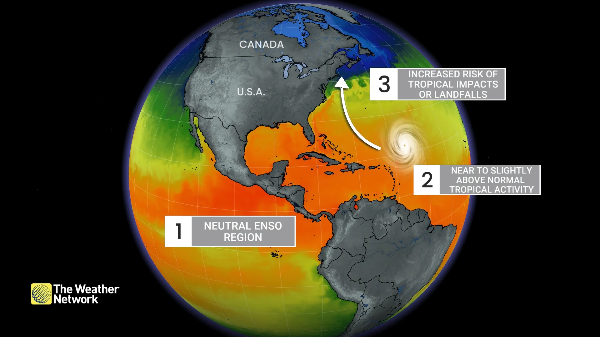
The Atlantic hurricane season is expected to be near normal or slightly more active than normal. However, that actually means that the upcoming season should have fewer tropical storms and hurricanes than most of the seasons during the past decade.
But that does not mean that we can let our guard down across Eastern Canada. The anticipated jet stream pattern would bring an elevated risk for a tropical system to track into the U.S. Northeast (which would also impact eastern Ontario and southern Quebec) and Atlantic Canada.
On the other hand, we expect a quieter-than-normal season in the deep tropics (including the Caribbean), but more storms are expected to form north of the Main Development Region (MDR), and those storms would have a higher potential to impact North America.
WATCH BELOW: Canadian hurricane outlook released for the 2025 season
Summer in Canada provides wonderful opportunities to enjoy the great outdoors and explore the diverse beauty of our country. However, summer weather also comes with potential risks. Please stay informed about the local forecast to ensure a safe and enjoyable summer!