A normal July brings Canada drought, downpours, and dizzying heat

An average July features steamy, stormy weather across Canada
July is the heart of summer across Canada—and it’s usually the hottest month of the year for much of the country.
We’re beyond the summer solstice and direct sunshine has had plenty of time to heat the atmosphere. A steady stream of moisture surging north of the border—and evaporating from Canada’s abundant crops—adds a muggy accent to the month's sizzling heat.
Here’s what you can expect across the country during a normal July.
DON’T MISS: What’s the wettest month in your corner of Canada?
Uncomfortable heat and humidity are the norm
This is the hottest time of the year for just about everyone across the country.
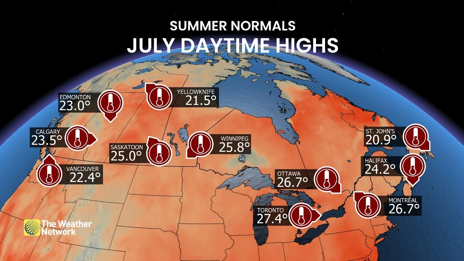
Toronto’s average daytime high during a typical July comes in around 27°C, with similar readings over in Ottawa and Montreal.
Normal daytime highs through the month average around the mid-20s on most of the Prairies, as well as for folks in the Maritimes. Ocean breezes help keep things a bit cooler in both Vancouver and St. John’s.
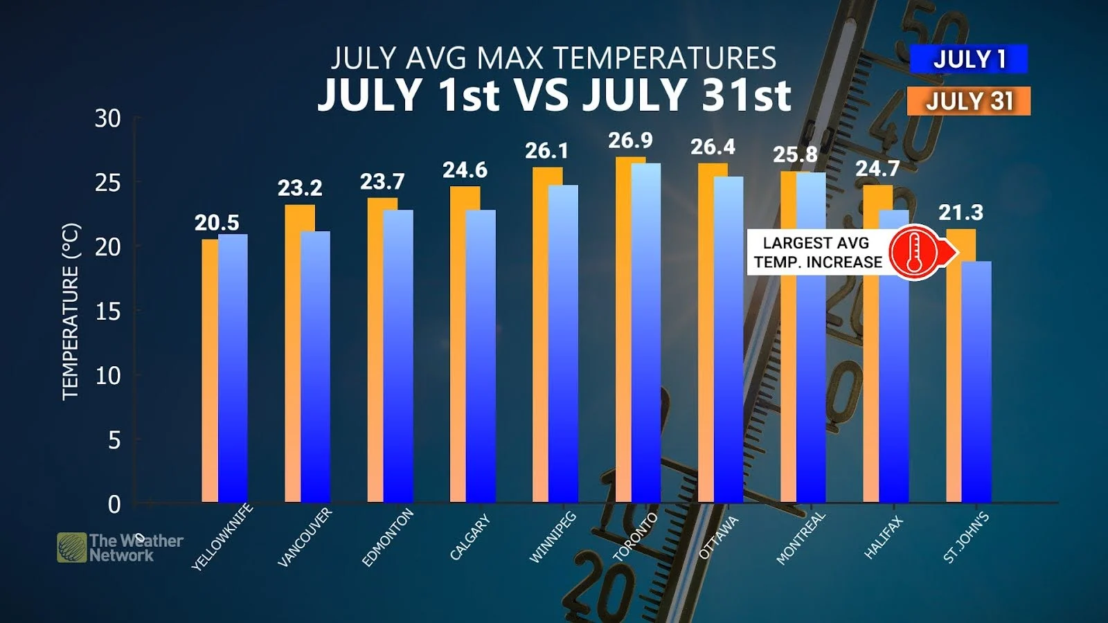
These are just generalized averages, of course. Temperatures can—and often do—come in much hotter throughout a normal July. And our day-to-day average daytime temperatures tend to rise between the beginning and the end of the month.
Almost every major city across Canada sees a warmer daytime high on the last day of July than they do on the first day of the month.
Heat is only one part of the equation. High humidity can make a sizzling July afternoon downright dangerous. Extreme heat affects everyone. Make sure to take it easy, stay hydrated, and don’t overdo it in the heat of the day—even if you think you’ll be fine.
July rainfall is feast or famine from coast to coast
Precipitation trends during the heart of summer can vary widely from one region to the next.
Drought isn’t uncommon as centres of high pressure bring high heat and relentless sunshine. On the flip side, one potent thunderstorm can drench a community with an entire month’s worth of rain in a single afternoon. Flash flooding is possible during a robust storm on a hot July afternoon.
RELATED: Tornado season is underway in Canada. Here’s what you need to know
How much rain falls throughout the month? It really depends on where you live.
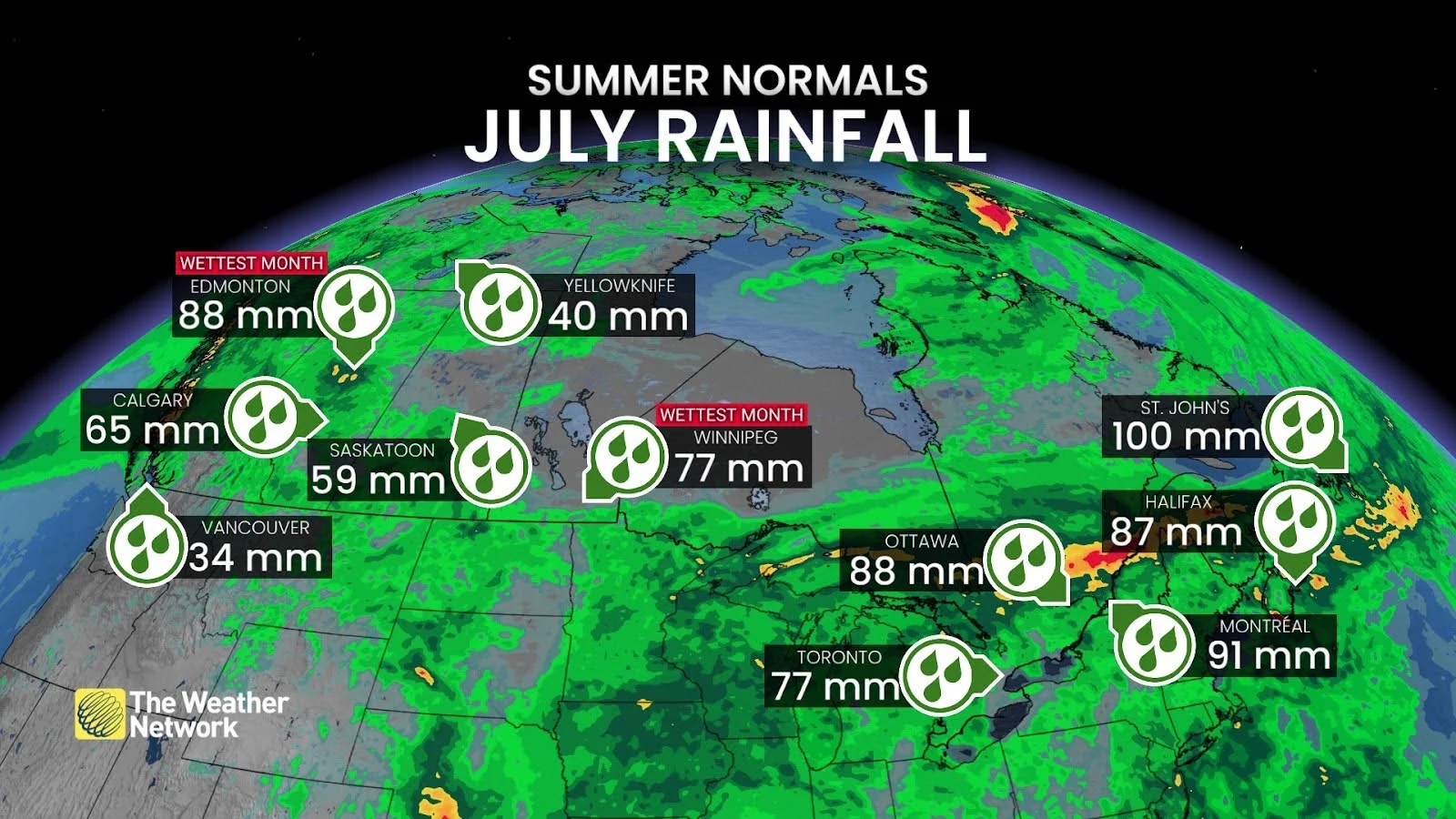
July is typically the wettest month of the year in Edmonton, where they average 87.2 mm of precipitation, as well as over in Winnipeg, Quebec City, and Whitehorse. However, this often turns out to be the driest month of the year in both Vancouver (34.1 mm) and Halifax (86.7 mm).
Those storms can produce more than just downpours. July is traditionally the peak of tornado season across the country. Whether you're at home, at work, or on the road, make sure you know what to do if a tornado warning is issued for your area.
Canadians have to start watching the tropics
July begins the long upswing toward the heart of hurricane season across the Atlantic basin.
Even though the season doesn’t peak until the second week of September, early-season storms are common across the basin—and some of them can grow quite strong.
Coastal residents should be prepared for landfalling storms any time throughout the season.
The remnants of tropical systems can pose serious hazards to Ontario and Quebec, as well. Communities can still feel the flooding rains, high winds, and tornadoes associated with tropical systems even hundreds (or thousands) of kilometres inland from the ocean.
Header image created using graphics and imagery from Canva.