An inside look at Hurricane Erin’s astounding rise to Category 5

Hurricane Erin is only the 43rd Category 5 storm ever observed in the Atlantic Ocean
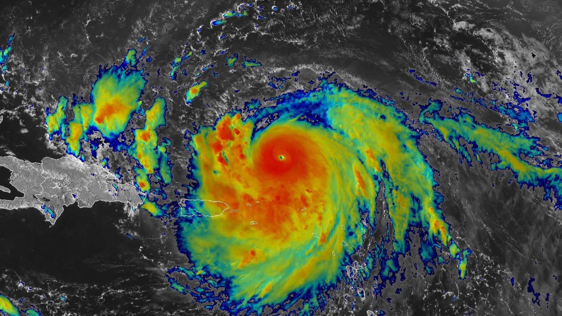
Hurricane Erin rapidly intensified into a ‘catastrophic’ Category 5 storm over the open Atlantic Ocean on Saturday. The storm achieved its scale-topping status just 24 hours after it first grew into a hurricane, and it maintained peak intensity for about nine hours.
Erin now joins an infamous handful of Atlantic hurricanes ever recorded at Category 5 intensity.
Here’s an inside look at Hurricane Erin’s astonishing rise—and how it compares to previous historic storms.
DON'T MISS: How a mammoth hurricane rapidly intensifies in mere hours
Erin is a rare, powerful hurricane
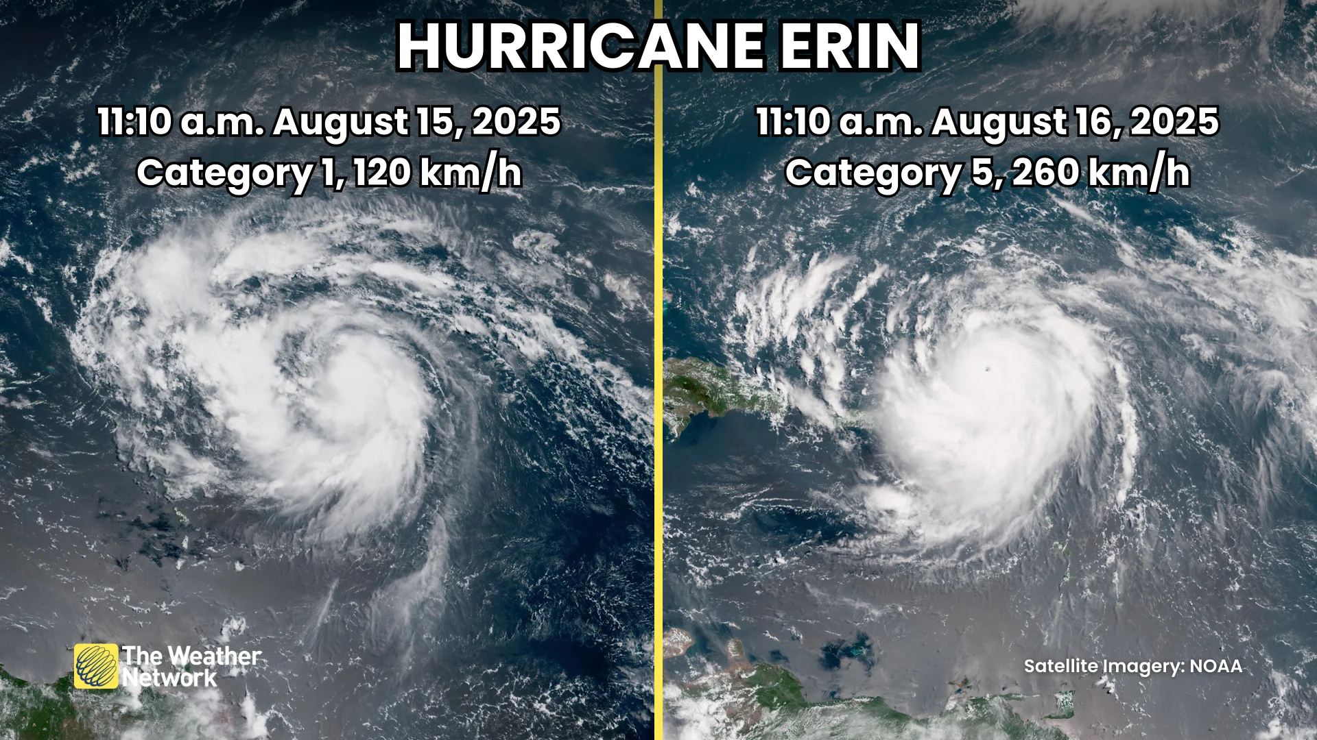
Faced with warm waters and a favourable atmosphere, reconnaissance aircraft flying through Hurricane Erin on Saturday found that it rapidly intensified into a Category 5 storm just after 11:00 a.m. EDT with maximum sustained winds of 260 km/h. The storm was a Category 1 hurricane with 120 km/h winds just 24 hours earlier.
A storm reaching Category 5 is a rare feat in and of itself.
The Atlantic Ocean has spawned 964 hurricanes since reliable records began back in 1851. Just over 35 per cent of those storms—339 hurricanes—made it to major hurricane strength with winds of Category 3 intensity or higher.
Only 43 of those storms achieved scale-topping Category 5 strength, representing just over 4 per cent of all hurricanes ever observed in the Atlantic basin.
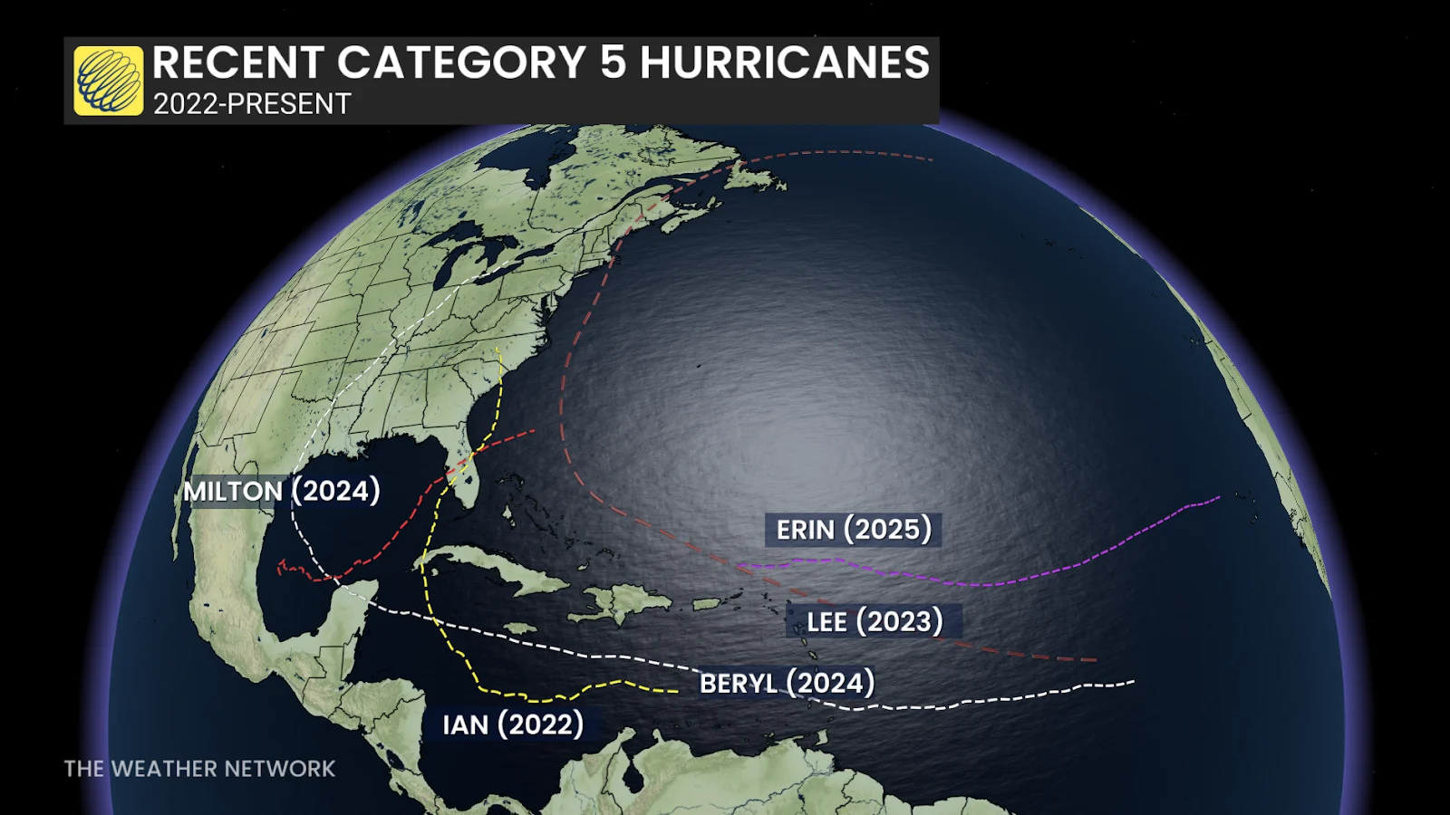
Even more stunning is the fact that Erin is the Atlantic’s fifth Category 5 storm since 2022, and the basin’s eleventh such storm since 2016.
This is also the fourth-earliest Category 5 hurricane ever observed across the Atlantic, falling behind Beryl (July 2, 2024), Emily (July 16, 2005), and Allen (Aug. 5, 1980).
Rapid intensification is a scary prospect
Erin’s status on the Saffir-Simpson Hurricane Wind Scale isn’t the storm’s only uncommon trait. The rate at which its winds intensified places it on the upper-end of all Atlantic hurricanes on record.
MUST SEE: Hurricane forecasts are better today than ever before—here’s how

A storm rapidly intensifies when its maximum sustained winds jump 30 knots (about 55 km/h) in 24 hours.
Observations found that Erin’s maximum sustained winds ratcheted up from 120 km/h to 260 km/h in just 24 hours, making it one of the swiftest bouts of rapid intensification ever observed. The system's relatively compact size likely aided its quick rise. Hurricane force winds only extended 45 km from the eye of the storm for most of the day Saturday.
This is the nineteenth major hurricane in the Atlantic basin to undergo a period of rapid intensification since 2020. Out of those 19 storms, only Hurricane Milton in 2024 witnessed a higher rate of strengthening—its winds increased from 145 km/h to 280 km/h within about 12 hours.