
The deadly heat wave that spawned a destructive Ontario derecho

The infamous heat wave of July 1995 claimed more than 500 lives in Chicago alone
A brutal heat wave that developed in July 1995 led to a powerful derecho that caused a significant swath of damage across Ontario.
The initial slow-motion disaster focused on the Chicago metro area, where more than 500 people died as a result of the intensely hot temperatures. Hundreds more died from heat-related illnesses across the U.S. Midwest.
DON’T MISS: Why extreme heat is one of the world’s deadliest weather disasters
Deadly heat wave claimed hundreds of lives
A powerful ridge of high pressure developed over the southwestern Great Lakes during the middle of July 1995. Temperatures beneath this ridge soared beyond the 40-degree mark in many locations.
Southerly winds and abundant crop growth pushed the humidity to unbearable levels. The atmosphere over the Midwest was packed with richer humidity than you’d find in the heart of the tropics.
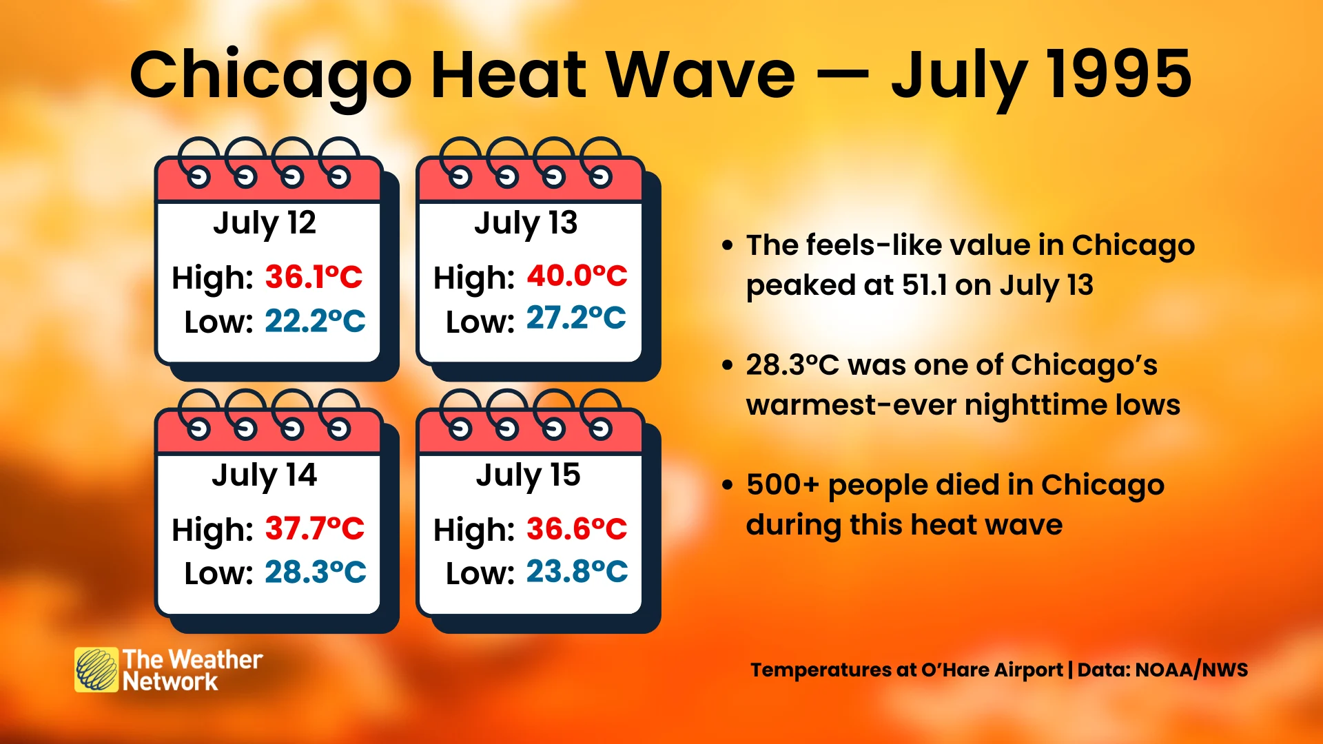
The heat began on July 12 and continued through July 15. Temperatures peaked in Chicago on July 13, when the high temperature at O’Hare International Airport hit 40°C (104°F).
Combined with humidity, feels-like values rose above 50 throughout the Chicago metro area. The following night only saw a low temperature of 28.3°C (83°F), which made for one of the city’s warmest nights ever reliably observed.
Heat is one of the deadliest weather disasters we’re likely to encounter. Several days of excessively hot temperatures followed by stifling nights can take a toll on even the healthiest individuals.
Chicago alone saw more than 500 heat-related fatalities during the heat wave, fundamentally changing how forecasters and local emergency officials handle the threat of extreme heat.
Destructive derecho followed the heat
The outer edge of a heat ridge is fertile grounds for severe thunderstorm development. These clusters of storms, called a mesoscale convective system (MCS), can race around the ridge like a train on railroad tracks.
RELATED: What is a mesoscale convective system? How an 'MCS' can spell danger
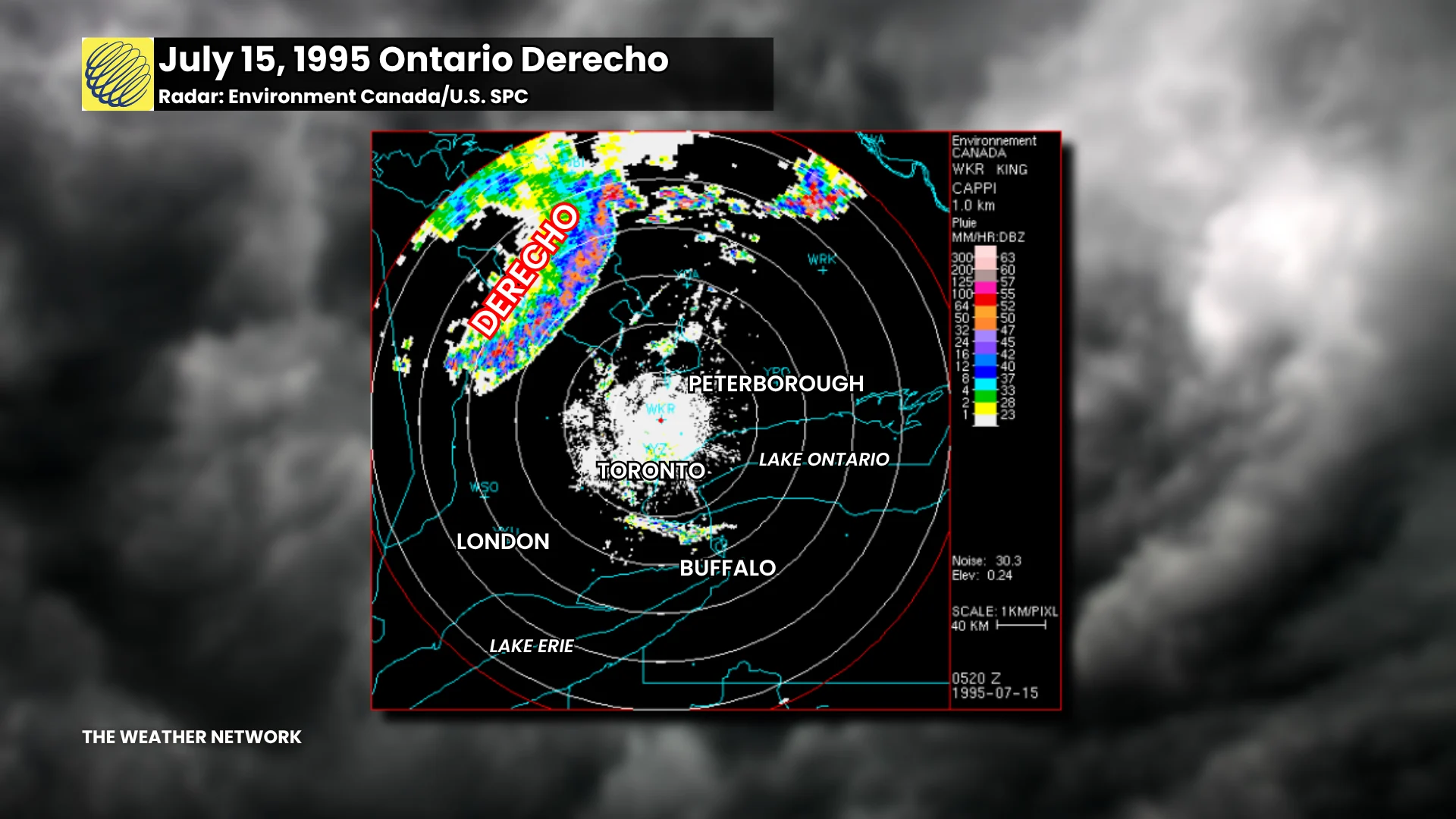
One such cluster of storms formed near Sault Ste. Marie late in the evening on July 14. This line of storms would spend seven hours racing southeast across Ontario as a derecho—a long-lived line of storms that produced a widespread swath of damaging winds.
Cottage country took the brunt of the derecho’s powerful winds.
According to the U.S. Storm Prediction Center (SPC), “thousands of trees were blown down, with some blocking roadways, severing electrical lines, and damaging or destroying homes and automobiles.”
“Power outages along the severe damage swath over south central Ontario would last for several days to a week,” the SPC’s writeup of the event added.
Header image of a thunderstorm's shelf cloud courtesy of André Belisle.