One year later: How a billion-dollar flood exposed Toronto’s climate risk

The deluge on July 16, 2024 flooded roads and homes across Toronto and southern Ontario, wracking up $940 million in insured damage. Here's how that event revealed Toronto's climate risk vulnerabilities
July marks the heart of the summer season in Canada and that includes a variety of extreme weather events are possible--everything from heat and drought to tornadoes and floods.
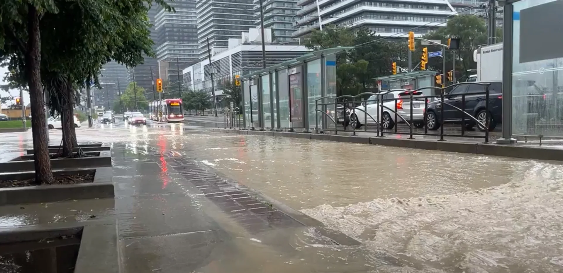
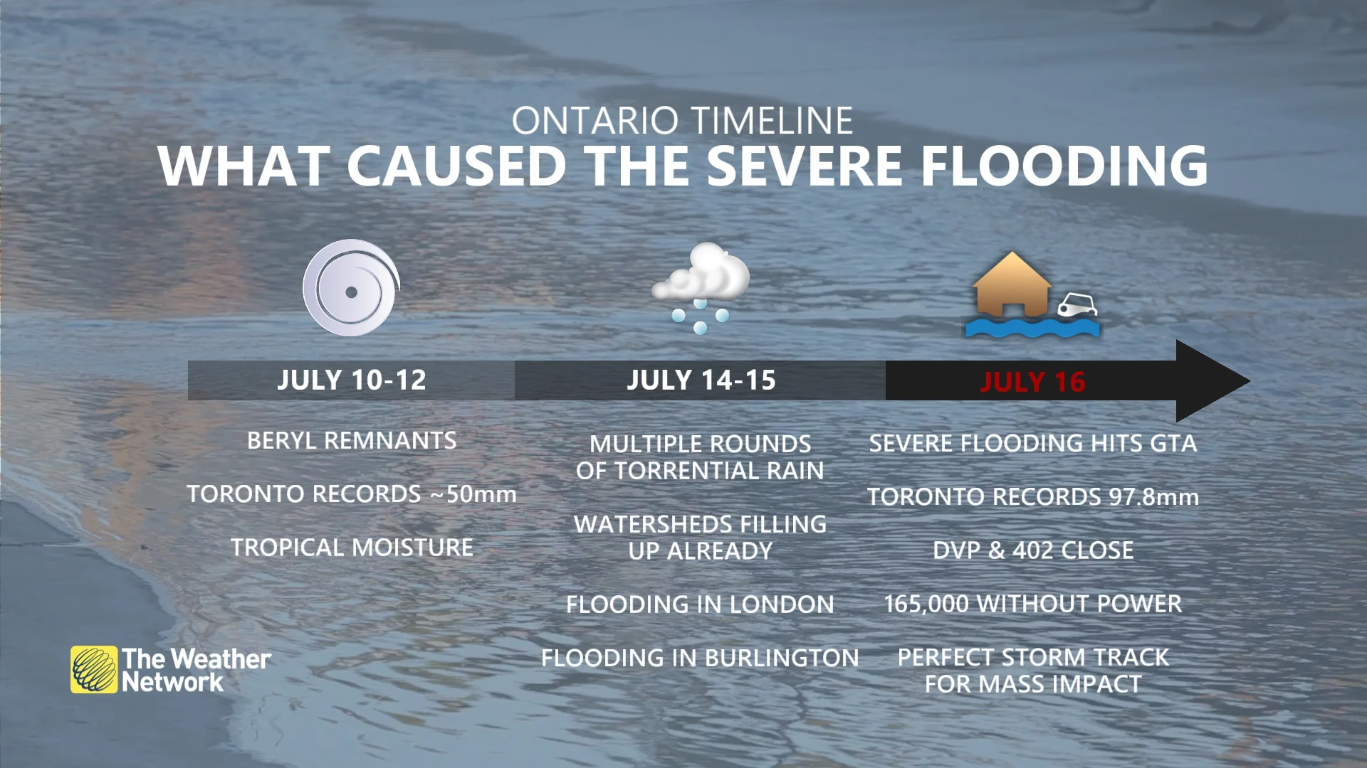
As proof, on July 16, 2024, Toronto, Ont., and other southern Ontario communities experienced devastating flooding. Pearson International Airport picked up a whopping 97.8 mm of rain on that Tuesday morning –– more than a month's worth. The 1991-2020 climate normals for July rainfall in Toronto is 74 mm.
RELATED: How weather and landscape set the stage for Toronto's latest flood
The flooding impacts in the city and surrounding communities were widespread and considerable. Numerous rivers were breached, with the Don Valley and Humber waterways pushed to very high levels, transit locales such as Union Station were flooded, resulting in closures and delays, and roads became impassable and were shut down.
As well, the extreme rain and flooding prompted closures on the 400-series highways. On top of that, at one point during the storm, there were more than 165,000 Toronto Hydro customers without power.
The July 16 flooding in Toronto and southern Ontario resulted in more than $940 million worth of insured damage, the Insurance Bureau of Canada (IBC) announced Monday.
What led to the damaging 2024 floods?
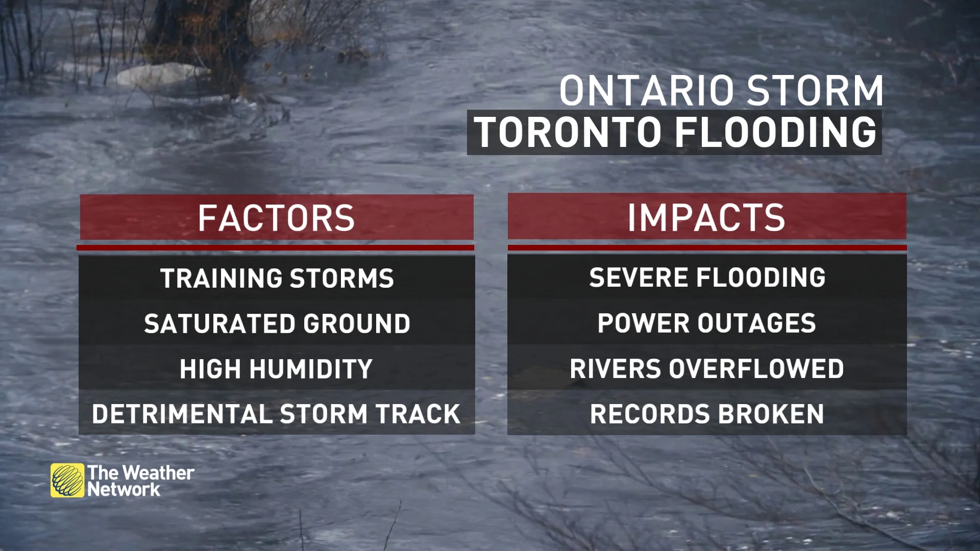
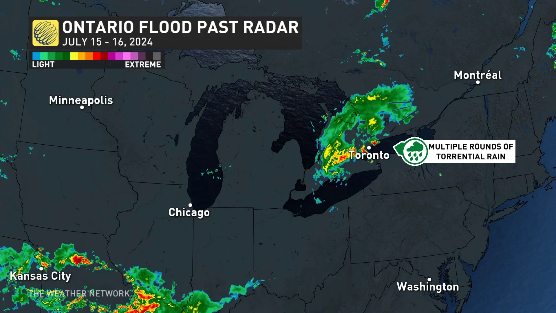
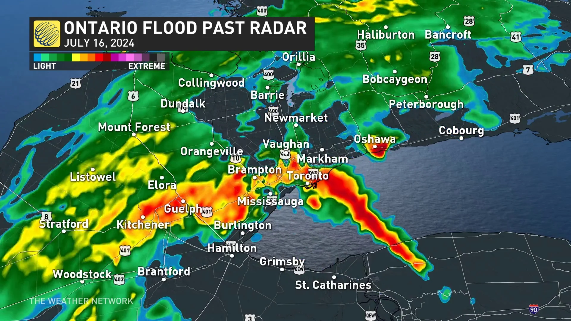
Much of what happened on July 16, 2024 can be attributed to, in large part, the upper-level winds, helping to steer a significant moisture anomaly, via a convective system, towards southern Ontario.
July 16, 2024 Baron radar image of precipitation for southern Ontario. (The Weather Network)
The significant moisture anomaly is what led to heavy, flooding rain in multiple Ontario communities this week, not just in Toronto on July 16.
The event started in the U.S. as a line of severe storms came tracking towards the Great Lakes region, with the convective system continuing through southern Ontario in the early-morning hours on Tuesday.
Two rounds of torrential rainfall occurred on that Tuesday morning, followed by wraparound, training storms with additional, heavy precipitation.
July 16, 2024 Baron radar image of precipitation for southern Ontario. (The Weather Network)
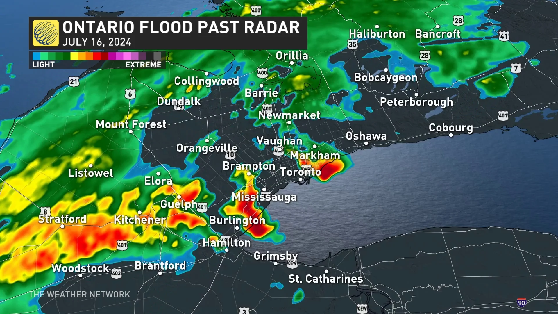
In essence, the perfect storm path aligned to cross the high-population centres of London, Burlington, Mississauga, Brampton and Toronto.
WATCH | One Year Later: Days of flooding rain hit the GTA with a $1B price tag
The event was driven by exceptionally high precipitable water values (PWAT), a measure of the total water vapour in a column of air. On July 16, PWAT values resembled those found in tropical air masses, reaching nearly 40 mm––allowing for extremely efficient rainfall.
SEE ALSO: Action needed as Canada loses nearly 300 football fields of grasslands daily_
Moreover, the soil was already saturated from earlier July rains, including from the remnants of Hurricane Beryl. That left the region’s rivers, creeks and drainage systems little capacity to handle another soaking.
Wednesday, July 10 saw 46.1 mm of rain fall in Toronto with another 25.1 mm accumulated on Monday, July 15.
July 16, 2024 Baron radar image of precipitation for southern Ontario. (The Weather Network)
Toronto lacks enough natural buffers to absorb rainfall
Climate change does play a role in contributing to an increase in the number of extreme weather events, but there are other factors to consider for the excessive rainfall and flooding on July 16, 2024.
Toronto has undergone decades of urbanization, removing natural infrastructure such as wetlands, grasslands and forested areas, which all work as sponges to absorb rainfall and mitigate flooding effects.

(Getty Images)
WATCH: Flooding rain shuts down major roads and transit in Toronto
Natural landscape such as grasslands can trap and filter water resources, mitigating floods and droughts in the process.
But, the city has replaced much of those with concrete roadways, driveways and buildings, among others. On top of that, Toronto's aging infrastructure is in need of serious upgrades –– an issue that also exacerbates the flooding risk, even in seemingly less extreme rainfall events.
What will Toronto do to mitigate impact of future flooding events?
However, on that day, Toronto Mayor Olivia Chow stated the city has found $2 billion in the budget after the provincial government "uploaded" the cost of the DVP and the Gardiner Expressway repairs, and will be allocated to fixing Toronto's aging transit system and roads, CBC News reported on July 16, 2024..
Toronto's infrastructure is still lagging, however, with Chow noting it is $26 billion and more than 10 years behind in repairs.
As well, announced in August 2024, the Black and Lavender creeks in the Rockcliffe-Smythe area of Toronto will be enhanced to reduce the risk of flooding after a cumulative investment of more than $323 million from the federal government and the City of Toronto.
A new flood protection wall, several bridges and complete culvert replacements will be part of the upgrades to the aforementioned creeks. As well, improvements will be made to the local sewer system and roads.
WATCH: Four Canadian weather events made 2024 the costliest year on record
With files from Rachel Modestino and Tyler Hamilton, meteorologists at The Weather Network.